
Poesten Kill facts for kids
Quick facts for kids Poesten Kill |
|
|---|---|

Poesten Kill adjacent to New York Route 2 in Brunswick
|
|

Watershed of the Poesten Kill and its tributaries
|
|
| Country | United States |
| State | New York |
| Region | Rensselaer County |
| Physical characteristics | |
| Main source | Dyken Pond Berlin, New York, United States 1,624 ft (495 m) 42°43′2.74″N 73°25′40.58″W / 42.7174278°N 73.4279389°W |
| River mouth | Hudson River Troy, New York, United States 0 ft (0 m) 42°43′14.49″N 73°41′54″W / 42.7206917°N 73.69833°W |
| Length | 26.2 mi (42.2 km) |
| Basin features | |
| River system | Hudson River Watershed |
| Basin size | 89.4 sq mi (232 km2) |
| Tributaries |
|
The Poesten Kill is a 26.2-mile-long (42.2 km) creek in upstate New York. It flows entirely within Rensselaer County. The creek starts at Dyken Pond in Berlin. It then flows west until it reaches the Hudson River in Troy.
For a long time, people living nearby and farmers used the Poesten Kill for water. It became even more important during the Industrial Revolution. This was a time when many mills and factories were built along its banks. They used the creek's water power to run their machines.
The creek's name comes from a local farmer and miller named Jan Barensten Wemple. He lived near the creek in the 1660s and was also known as "Wemp" or "Poest." The word "Kill" comes from the Dutch word kill, which means "creek."
Contents
Exploring the Poesten Kill's Geography
The Poesten Kill starts at Dyken Pond. This is a lake made by people in the Petersburg Mountains. It was created in 1902 by the Manning Paper Company. They wanted to control the water flow and stop floods. Dyken Pond gets its water from local streams and springs. It is located near the towns of Grafton, Berlin, and Poestenkill. The pond is about 1,624 feet (495 m) high.
Tributaries: Creeks Joining the Poesten Kill
Many small streams flow into the Poesten Kill. However, there are four main creeks that join it:
- Bonesteel Creek: This creek flows south from Bonesteel and Hosjord Ponds. It meets the Poesten Kill in the town of Poestenkill. Bonesteel Creek is about 5.4 miles (8.7 km) long.
- Newfoundland Creek: This creek joins the Poesten Kill just west of the hamlet of Poestenkill. It is about 3.6 miles (5.8 km) long.
- The Quacken Kill: This creek connects with the Poesten Kill near the Brunswick border. It starts at Long Pond in Grafton Lakes State Park. It then flows through Second Pond and Mill Pond in the park. After that, it goes through Dunham Reservoir near central Grafton. The Quacken Kill is about 15.9 miles (25.6 km) long.
- Sweet Milk Creek: This creek starts in north central Brunswick. It travels about 4.7 miles (7.6 km) before joining the Poesten Kill in the southwestern part of the town.
The Poesten Kill flows for about 26.2 miles (42.2 km) through Rensselaer County. Then, it empties into the Hudson River. Between 1924 and 1968, the Poesten Kill's water flow was measured. It had an average flow of 130 cu ft/s (3.7 m3/s). Its highest flow during that time was about 2,897 cu ft/s (82.0 m3/s).
Amazing Waterfalls Along the Creek
The Poesten Kill and its smaller creeks have several beautiful waterfalls.
-
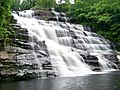
Barberville Falls in Poestenkill
-
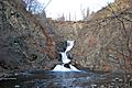
High Falls in Troy
-
-


A Look Back: History of the Poesten Kill
The Dutch and Early Settlements
Before Europeans arrived, the Mohican people lived on the land around the Poesten Kill. The first lasting European settlement was Fort Orange. This was a trading post built by the Dutch West India Company in 1624. It was about 10 miles (16 km) south of where the Poesten Kill meets the Hudson River. However, the area where the Poesten Kill meets the Hudson is considered the first real European settlement outside Fort Orange.
In 1630, the Mohicans sold a large area of land to Kiliaen van Rensselaer. He was a Dutch merchant and businessman. With this land, Van Rensselaer started a special type of settlement called a patroonship. This was like a large estate, and his, called Rensselaerswyck, was the only successful one in the Dutch colonies. Van Rensselaer named the land around the mouth of the Poesten Kill Pafraets Dael, after his mother. You can see this name on the first map of Rensselaerswyck.
The Dutch also gave the creek its name. In 1661, Jan Barentse Wemp, a farmer and trader, leased a farm. This land stretched from the Poesten Kill south to the Wynants Kill. People often used nicknames back then. Wemp was known as "Poest." When you add the Dutch word kill (meaning "creek"), you get "Poesten Kill."
Most early settlements near the Poesten Kill were for farming. But some were also important for trading furs with the Mohicans. This fur trade was very profitable, even though it was technically illegal for individuals at the time. In 1664, the English took over Rensselaerswyck.
In the 1600s, a sawmill was built at the base of the Poestenkill falls by Jan Barensten Wemple. After he passed away, his wife, Marytie Mynderse, took over the mill. In the 1800s, many more mills and factories were built along the river. They used the water power and had easy access to the Hudson River. Remains of these old factories can still be seen today.
Staying Safe Near the Poesten Kill Falls
The Poestenkill falls are a beautiful place for hikers and visitors. However, it's important to be careful around the fast-moving water, especially after heavy rains or when snow melts in winter. The currents can be very strong and dangerous. Always follow safety signs and warnings when exploring near the falls.
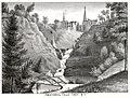
The Poestenkill Gorge Today
Today, there are two ways to access the Poestenkill Gorge. On the north side of the river, a private company has a small power station. It was built in the 1950s and still makes electricity using water power. This station uses the remains of old industrial mills.
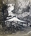
There used to be a gate blocking the entrance to this area, but it has been removed. This road has been around since the 1870s. However, the city of Troy stopped maintaining this park in the 1990s, even though they still own the land. The road leads to a small dirt path. This path is covered with young trees and roots. It follows along the remains of old factories, like the Marshall Factories.
The path splits into two. One path leads to the large foundation of an old mill, with one brick archway still standing. Along the northern river bank, you can see old stone bricks and shale from mill foundations. There are also clay bricks that say "Bleau" on them. These bricks were made in a factory across the Hudson River in Mechanicville. They were used to build a mill in the 1700s. You can also see steel rods from where bridges and walkways used to cross the gorge.
Walking along the riverbank can be tricky because of all the rubble and driftwood. The rock walls of the waterfalls show how much dirt and clay have been washed away by the constant water flow. In the spring, when snow melts, the water flows much more powerfully. This can make it hard to get close to the waterfall riverbanks.
