
Pontenet facts for kids
Quick facts for kids
Pontenet
|
||
|---|---|---|

Looking across the fields toward Pontenet village
|
||
|
||

Pontenet
Location in Switzerland

Pontenet
Location in Canton of Bern
|
||
| Country | Switzerland | |
| Canton | Bern | |
| District | Jura bernois | |
| Area | ||
| • Total | 2.74 km2 (1.06 sq mi) | |
| Elevation | 741 m (2,431 ft) | |
| Population
(Dec 2011)
|
||
| • Total | 216 | |
| • Density | 78.8/km2 (204.2/sq mi) | |
| Postal code |
2733
|
|
| Surrounded by | Loveresse, Souboz, Malleray | |

Pontenet was a small town, or 'municipality,' in Switzerland. It was located in the Bern canton, a region where people speak French. On January 1, 2015, Pontenet joined with two other towns, Bévilard and Malleray, to create a new, larger town called Valbirse.
Contents
History of Pontenet
Pontenet was first mentioned in old records in the year 1359. At that time, it was called Pontenat.
Early Times
By 1371, a place called Bellelay Abbey owned a lot of land in the village. In 1515, they gave their land to a person named Grosjean Girod de Loveresse. For many years, the town was managed by the leader of Moutier-Grandval Abbey. This leader worked for the Prince-Bishop of Basel.
In 1750, the Birs river flooded. This flood destroyed the village's mill, sawmill, and the bridge over the river.
French Influence and Swiss Change
In 1797, France won a big war. After this, Pontenet became part of a French area called Mont-Terrible. Three years later, in 1800, it became part of another French area, Haut-Rhin.
After Napoleon was defeated, Pontenet became part of the Canton of Bern in Switzerland in 1815. Throughout its history, Pontenet was part of the church area of Bévilard.
Modern Developments
In 1876, a train line was built near Pontenet. However, trains did not stop in Pontenet until 1918. Over time, some small workshops grew up along the road and railroad.
Geography of Pontenet

Before Pontenet joined with other towns, it covered about 2.7 square kilometers (about 1 square mile).
Land Use
Most of Pontenet's land was used for farming. About 48.4% of the area was farmland. Forests covered a large part too, about 44.3%. Buildings and roads made up about 6.2% of the land.
In the forested areas, 38.5% was dense forest. Another 5.9% had orchards or small groups of trees. For farming, 8.8% was used for crops. About 12.8% was used for pastures where animals graze. Some land (1.5%) had orchards or vineyards. The rest (25.3%) was used for high mountain pastures.
Location
Pontenet is located in the Tavannes valley. It sits at the bottom of a mountain called Moron.
On December 31, 2009, the old district of Moutier was closed. The next day, Pontenet became part of the new Jura bernois district.
Pontenet's Coat of Arms
The town's coat of arms is red with a silver bridge and a silver star. The word for bridge in French is pont. This is why the bridge is on the coat of arms, as it sounds like the town's name. This is called "canting arms."
People of Pontenet (Demographics)
.jpg)
In 2013, Pontenet had a population of 217 people. In 2010, about 9.6% of the people living there were from other countries. Over ten years (2001–2011), the number of people in Pontenet grew by 3.3%. This growth was mostly because new people moved in.
Languages Spoken
Most people in Pontenet speak French. In 2000, about 89.5% of the people spoke French as their main language. The second most common language was German, spoken by 9.5% of the people. A small number (0.5%) spoke Italian.
Population Details
In 2008, about 51.7% of the people were male and 48.3% were female. Most of the people were Swiss citizens.
In 2000, about 27.9% of the people living in Pontenet were also born there. Many others (41.6%) were born in the same canton (Bern). About 19.5% were born elsewhere in Switzerland. Only 7.9% were born outside of Switzerland.
In 2011, children and teenagers (ages 0–19) made up 25% of the population. Adults (ages 20–64) were 56%, and seniors (over 64) were 19%.
Family Life
In 2000, 73 people in Pontenet were single and had never been married. There were 100 married people, 9 widows or widowers, and 8 divorced people.
In 2010, 26 homes had only one person living in them. Six homes had five or more people. Most apartments (79.4%) were lived in all year round. Some (14.4%) were used only at certain times of the year, and 6.2% were empty. In 2011, single family homes made up 65.4% of all homes in Pontenet.
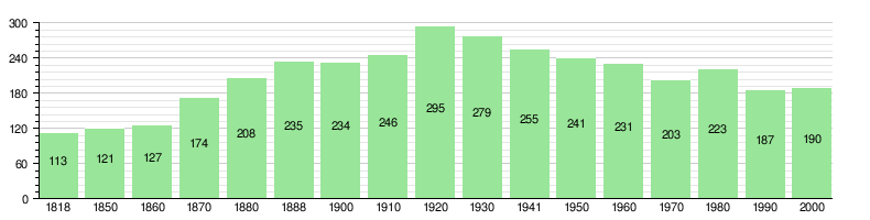
Population Over Time
The chart below shows how the population of Pontenet has changed over many years:
Economy of Pontenet
In 2011, the unemployment rate in Pontenet was low, at 1.28%.
Jobs and Businesses
In 2008, 42 people worked in Pontenet.
- 10 people worked in agriculture (farming). There were 4 businesses in this area.
- 9 people worked in manufacturing (making things). There were 2 businesses in this area.
- 23 people worked in the service industry (like shops or offices). There were 6 businesses in this area.
Overall, 95 people who lived in Pontenet had jobs. About 45.3% of these workers were women.
Commuting and Transportation
In 2000, 30 workers came into Pontenet for their jobs. However, 73 workers left Pontenet to work in other towns. This means more people left Pontenet for work than came in. About 22 workers (42.3% of all workers in Pontenet) both lived and worked in the town.
To get to work, 4.2% of people used public transportation. A much larger number, 74.7%, used a private car.
Religion in Pontenet
Based on a 2000 survey:
- About 61.6% of the people belonged to the Swiss Reformed Church (a type of Protestant church).
- About 20.0% were Roman Catholic.
- A small number (2.63%) belonged to other Christian churches.
- One person was Islamic.
- About 13.16% of the people did not belong to any church. They were either agnostic (not sure about God) or atheist (do not believe in God).
- About 2.11% of the people did not answer the question about their religion.
Education in Pontenet
In Pontenet, many people have a good education. About 55.9% of the population finished high school (non-mandatory upper secondary education). Also, 12.7% went on to higher education, like a university.
School System
The school system in the Canton of Bern works like this:
- One year of optional Kindergarten.
- Six years of Primary school.
- Three years of required lower Secondary school. In this school, students are grouped by their abilities.
- After lower Secondary, students can continue their education or start an apprenticeship (learning a job while working).
Local Schools
During the 2011–12 school year, 17 students attended classes in Pontenet. There were no kindergarten classes in the town. Pontenet had one primary school class with 17 students. Of these primary students, 17.6% were not Swiss citizens. Also, 17.6% spoke a different language at home than the language used in the classroom.
In 2000, 21 students went to school in Pontenet. Most of them (20 students) lived and went to school in the town. Only one student came from another town. In the same year, 10 students who lived in Pontenet went to schools outside the town.
See also
 In Spanish: Pontenet para niños
