Port St. Lucie, Florida facts for kids
Quick facts for kids
Port St. Lucie, Florida
|
|
|---|---|
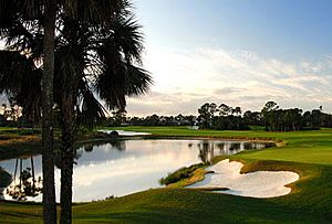
PGA Golf Club in Port St. Lucie
|
|
| Motto(s):
Heart of the Treasure Coast
|
|
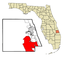
Location in St. Lucie County and the state of Florida
|
|
| Country | |
| State | Florida |
| County | St. Lucie |
| Incorporated | April 27, 1961 |
| Government | |
| • Type | Council-Manager |
| Area | |
| • City | 120.83 sq mi (312.94 km2) |
| • Land | 119.22 sq mi (308.77 km2) |
| • Water | 1.61 sq mi (4.17 km2) |
| Elevation | 16 ft (5 m) |
| Population
(2020)
|
|
| • City | 204,851 |
| • Rank | US: 92nd |
| • Density | 1,718.32/sq mi (663.45/km2) |
| • Urban | 437,745 (US: 93rd) |
| • Urban density | 1,952.2/sq mi (753.8/km2) |
| • Metro | 487,657 (US: 112th) |
| Time zone | UTC−05:00 (Eastern (EST)) |
| • Summer (DST) | UTC−04:00 (EDT) |
| ZIP codes |
34952-34953, 34983-34988
|
| Area code(s) | Area code 772 |
| FIPS code | 12-58715 |
| GNIS feature ID | 0308089 |
Port St. Lucie is a large city in St. Lucie County, Florida, USA. It's the biggest city in the county and the seventh-largest in Florida. In 2020, over 204,000 people lived there. The city is about 125 miles (201 km) southeast of Orlando and 113 miles (182 km) north of Miami.
Port St. Lucie is a main city in the Port St. Lucie Metropolitan Statistical Area. This area includes St. Lucie and Martin counties. In 2021, about 502,521 people lived in this larger area.
Contents
History of Port St. Lucie
How Port St. Lucie Got Its Name
The name "St. Lucie" comes from an old settlement near Jupiter Inlet. It was started on St. Lucia's day in 1566. Because of some mistakes, the name later moved north to the town of St. Lucie Village, Florida. After "La Florida" and "St. Augustine," it's one of the oldest European place names still used in the United States.
In the early 1890s, a small pioneer town called Spruce Bluff existed. It was located along the St. Lucie River. This community had families, a school, a post office, and farms. Today, this land is part of the Spruce Bluff Preserve. You can find hiking trails, canoe access, and an ancient Ais Indian mound there.
Building a New City
In the 1950s, the area that is now Port St. Lucie was mostly empty land. There was a fishing camp and a few farms. In 1958, a company called General Development Corporation (GDC) bought a lot of land. They planned to build a new city.
In 1959, GDC built the first bridge over the St. Lucie River. This made it easier for cars to reach the new area. By February 1961, 250 homes were built. GDC asked the state to make Port St. Lucie an official city. On April 27, 1961, Port St. Lucie officially became a city.
Growth and New Communities
In the early 1990s, another company, Core Communities (CC), started planning St. Lucie West. This area was first meant for about 14,000 homes. But then, they decided to build more than just houses. They added businesses, entertainment, and fun places. This created 7,000 jobs and helped the city grow a lot in the early 2000s.
In 2006, CC began building a new community called Tradition. This area used to be a large cattle ranch. They built many shops and homes there. Tradition is designed to look like a 1950s town. Its town center, Tradition Square, hosts many events all year.
Economic Challenges and Innovation
Around 2007, the housing market faced some tough times. This led to more people losing their homes. The county even thought about asking for disaster help. This would have given them money for building projects like research parks and roads.
In 2008, Tradition welcomed the Florida Center of Innovation. This research park focuses on discovering new medicines and medical devices. It included places like Torrey Pines Institute for Molecular Studies. While some groups have left, Torrey Pines and Tradition Medical Center are still there.
In 2017, a company called TAMCO started plans to build a large manufacturing and distribution center. This big building was finished in late 2019.
Geography and Climate
Where is Port St. Lucie?
Port St. Lucie is located at about 27°16′33″N 80°21′18″W.
The city covers about 120.83 square miles (312.94 km²). Most of this area is land, with a small part being water.
City Neighborhoods
Since late 2019, Port St. Lucie has been naming its different neighborhoods. As of 2020, there are 33 neighborhoods, including:
|
|
|
Weather in Port St. Lucie
Port St. Lucie has a warm climate. Summers are usually hot, with temperatures often in the low 90s Fahrenheit (around 32-34°C). Winters are mild and warm, with highs in the 70s Fahrenheit (around 21-26°C). The city gets about 53.5 inches (1359 mm) of rain each year.
In 2004 and 2005, Port St. Lucie was hit by three hurricanes: Frances, Jeanne, and Wilma.
| Climate data for Port Saint Lucie, Florida | |||||||||||||
|---|---|---|---|---|---|---|---|---|---|---|---|---|---|
| Month | Jan | Feb | Mar | Apr | May | Jun | Jul | Aug | Sep | Oct | Nov | Dec | Year |
| Record high °F (°C) | 89 (32) |
90 (32) |
92 (33) |
97 (36) |
98 (37) |
101 (38) |
101 (38) |
98 (37) |
99 (37) |
96 (36) |
92 (33) |
89 (32) |
101 (38) |
| Mean daily maximum °F (°C) | 73 (23) |
75 (24) |
79 (26) |
82 (28) |
86 (30) |
90 (32) |
92 (33) |
91 (33) |
90 (32) |
86 (30) |
81 (27) |
76 (24) |
83 (28) |
| Mean daily minimum °F (°C) | 51 (11) |
52 (11) |
56 (13) |
61 (16) |
67 (19) |
71 (22) |
72 (22) |
72 (22) |
72 (22) |
67 (19) |
60 (16) |
54 (12) |
63 (17) |
| Record low °F (°C) | 23 (−5) |
28 (−2) |
26 (−3) |
33 (1) |
45 (7) |
56 (13) |
64 (18) |
61 (16) |
60 (16) |
42 (6) |
31 (−1) |
26 (−3) |
23 (−5) |
| Average precipitation inches (mm) | 2.7 (69) |
2.9 (76) |
3.3 (83) |
2.8 (70) |
4.4 (111) |
5.8 (148) |
5.8 (147) |
6.4 (161) |
7.8 (198) |
5.8 (148) |
3.5 (89) |
2.3 (58) |
53.5 (1,359) |
| Source: Weather Channel | |||||||||||||
People of Port St. Lucie
| Historical population | |||
|---|---|---|---|
| Census | Pop. | %± | |
| 1970 | 330 | — | |
| 1980 | 14,690 | 4,351.5% | |
| 1990 | 55,866 | 280.3% | |
| 2000 | 88,769 | 58.9% | |
| 2010 | 164,603 | 85.4% | |
| 2020 | 204,851 | 24.5% | |
| U.S. Decennial Census | |||
Population Growth
Port St. Lucie has grown a lot over the years. In 1970, only 330 people lived there. By 2020, the population had grown to 204,851 people!
Who Lives in Port St. Lucie?
The city is home to many different groups of people. In 2020, there were 204,851 people living in Port St. Lucie. This included 68,241 households and 51,199 families.
Most people in Port St. Lucie speak English. However, many other languages are also spoken. In 2000, about 6.59% of people spoke Spanish. Other languages like Italian, French, and Haitian Creole are also spoken.
Getting Around Port St. Lucie
Roads and Highways
Port St. Lucie has many roads to help people get around. The city takes care of over 900 miles (1,450 km) of roads.
![]() Florida's Turnpike is a toll road that runs through the city. It has two exits in Port St. Lucie. This road connects the city to Orlando in the north and Miami in the south.
Florida's Turnpike is a toll road that runs through the city. It has two exits in Port St. Lucie. This road connects the city to Orlando in the north and Miami in the south.
![]() Interstate 95 also runs through the western part of the city. It has five exits within Port St. Lucie. This highway connects to Jacksonville in the north and Miami in the south.
Interstate 95 also runs through the western part of the city. It has five exits within Port St. Lucie. This highway connects to Jacksonville in the north and Miami in the south.
![]() U.S. 1 runs along the eastern side of the city. It's lined with many shops and businesses.
U.S. 1 runs along the eastern side of the city. It's lined with many shops and businesses.
Crosstown Parkway is a newer road that opened in 2019. It connects Interstate 95 to U.S. 1. It also has Florida's first "superstreet" intersection.
![]() State Road 716, also known as Port St. Lucie Boulevard, connects U.S. 1 to Florida's Turnpike.
State Road 716, also known as Port St. Lucie Boulevard, connects U.S. 1 to Florida's Turnpike.
Public Transportation
Port St. Lucie has a bus system called Area Regional Transit (ART). It started in the 1990s and has grown over time. ART buses run on eight different routes, with five of them serving Port St. Lucie.
Airports and Trains
The closest airport with regular flights is Vero Beach Regional Airport, about 25 miles (40 km) north. Palm Beach International Airport is about 40 miles (64 km) south.
The Florida East Coast Railway (FEC) train tracks pass through the city. However, the FEC does not offer passenger services within Port St. Lucie.
Sports and Recreation
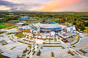
Port St. Lucie is a great place for sports! It's the spring training home for the New York Mets baseball team. Two minor league teams, the St. Lucie Mets and the Florida Complex League Mets, also play here. All three teams play at Clover Park.
The PGA Village golf complex has 54 holes of golf. It also has a learning center and a history center for golf fans. The city even hosted a big PGA Tour golf event in 2007.
For soccer fans, Port St. Lucie has two local clubs: Mako Soccer Club and Port St. Lucie Soccer Club. They have teams for different ages and skill levels. The Treasure Coast Tritons soccer team also plays in the city.
Port St. Lucie is also known for its Pop Warner football teams. The Jr. Midget Pirates won the National Championship in 2009, and the Jr. Peewee Pirates won in 2001!
Education in Port St. Lucie
St. Lucie County Public Schools serves all students in Port St. Lucie and St. Lucie County.
Elementary Schools
- Bayshore Elementary
- Floresta Elementary
- Mariposa Elementary
- Morningside Elementary
- Rivers Edge Elementary
- Village Green Environmental Studies School
- Windmill Point Elementary
K–8 Schools
These schools teach students from kindergarten to 8th grade.
- Allapattah Flats K-8
- Manatee K–8
- Northport K–8
- Oak Hammock K–8
- Palm Pointe Research School at Tradition
- St. Lucie West K–8
- West Gate K–8
K–12 Schools
These schools teach students from kindergarten all the way to 12th grade.
- Christ Lutheran School
- Grace Christian Academy
High Schools
- Port St. Lucie High School
- St. Lucie West Centennial High School
- Treasure Coast High School
Colleges and Universities
After high school, students can attend:
- Indian River State College
- Keiser University
- Fortis Institute
Charter Schools
- Renaissance Charter School at Tradition
- Renaissance Charter School of St. Lucie
- Somerset Academy Bethany
- Somerset Academy St. Lucie
- Somerset College Preparatory Academy
- Tradition Preparatory High School
Libraries in the City
Port St. Lucie has four library branches where you can find books and more:
- Morningside Library (19,000 square feet)
- Port St. Lucie Library (4,400 square feet)
- Paula A. Lewis Library (21,000 square feet)
- Pruitt Campus (a shared library with Indian River State College, 25,000 square feet)
Parks and Fun Places
Port St. Lucie has great parks and attractions to visit:
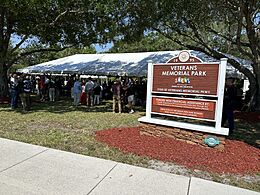
- Veterans Memorial Park
- Port St. Lucie Botanical Gardens
Famous People from Port St. Lucie
- Rick Ankiel, professional baseball player
- Mario Bencastro, Salvadorian novelist
- Michael Brantley, professional baseball player
- Donald De La Haye, professional football player and YouTube personality
- Ace Hood, hip hop artist
- Breanna Myles, beauty pageant titleholder
- Alycia Parks, professional tennis player
- Gillian Robertson, UFC fighter
- Larry Sanders (basketball), professional basketball player
- Fabrizio Scaccia, professional football player
- Din Thomas, UFC fighter
- Albert Wilson (American football), professional football player
- Mickey Wright, LPGA Hall of Fame
See also
In Spanish: Port St. Lucie (Florida) para niños


