
Poughkeepsie (town), New York facts for kids
Quick facts for kids
Poughkeepsie
|
||
|---|---|---|
| Town of Poughkeepsie | ||

Clockwise from top left: Locust Grove, Stone Street Historic District, Vassar College, Red Oaks Mill
|
||
|
||

Location of the town of Poughkeepsie, New York
|
||
| Country | United States | |
| State | New York | |
| County | Dutchess | |
| Government | ||
| • Type | Town Council | |
| Area | ||
| • Total | 31.2 sq mi (80.7 km2) | |
| • Land | 28.5 sq mi (73.9 km2) | |
| • Water | 2.6 sq mi (6.8 km2) | |
| Elevation | 230 ft (70 m) | |
| Population
(2020)
|
||
| • Total | 45,471 | |
| • Density | 1,520/sq mi (586.9/km2) | |
| Time zone | UTC-5 (Eastern (EST)) | |
| • Summer (DST) | UTC-4 (EDT) | |
| ZIP codes |
12601-12604
|
|
| Area code(s) | 845 | |
| FIPS code | 36-59652 | |
| GNIS feature ID | 0979393 | |

The Town of Poughkeepsie (say "pə-KIP-see") is a town in Dutchess County, New York, United States. In 2020, about 45,471 people lived there.
The name "Poughkeepsie" comes from a Native American phrase, "Uppuqui-ipis-ing." This means "the reed-covered lodge by the little water place." Over time, the name changed to Poughkeepsie.
A big IBM campus is located in the town. This campus is known for making large computers called IBM mainframes.
Contents
Exploring Poughkeepsie's Past
The town of Poughkeepsie was first settled around 1780. It became an official town in 1788. Later, in 1854, a part of the town became the separate City of Poughkeepsie.
Historic Landmarks in Poughkeepsie
Two important historical places are found in the town. These are the Vassar College Observatory and the Main Building at Vassar College. They are recognized as National Historic Landmarks.
Learning and Education in Poughkeepsie
Many colleges and schools are located in the Town of Poughkeepsie.
-
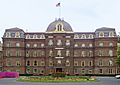
The Main Building at Vassar College
-
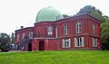
Vassar College Observatory
-

James A. Cannavino Library at Marist College
-
Marist College Hancock Center
-

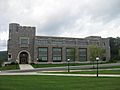
Taconic Hall of Dutchess Community College


Colleges and Universities
Vassar College, Dutchess Community College, and Marist College are all in the town. These colleges offer many different programs for students.
Local School Districts
Different parts of the town belong to various school districts. These include Arlington Central, Spackenkill Union Free, Hyde Park Central, and Wappingers Central.
Private Schools in the Area
- Our Lady of Lourdes High School is a private Catholic high school. It is located on Boardman Road.
- Poughkeepsie Day School is an independent school. It serves students from age 3 up to grade 12.
- Oakwood Friends School is a private middle and high school. It is found near State Route 113.
Poughkeepsie's Geography
The Town of Poughkeepsie covers about 80.7 square kilometers (31.2 square miles). Most of this area is land, with some water.
Rivers and Borders
The Hudson River forms most of the town's western edge. The City of Poughkeepsie also shares a border on the west. Other towns bordering Poughkeepsie include Hyde Park to the north and LaGrange to the east.
Major Roads and Routes
Several important roads pass through the town. These include U.S. Route 9, U.S. Route 44, and State Route 55.
Population Trends in Poughkeepsie
The population of the Town of Poughkeepsie has changed over many years.
| Historical population | |||
|---|---|---|---|
| Census | Pop. | %± | |
| 1820 | 5,726 | — | |
| 1830 | 7,222 | 26.1% | |
| 1840 | 10,006 | 38.5% | |
| 1850 | 13,944 | 39.4% | |
| 1860 | 3,122 | −77.6% | |
| 1870 | 4,009 | 28.4% | |
| 1880 | 4,628 | 15.4% | |
| 1890 | 4,782 | 3.3% | |
| 1900 | 6,820 | 42.6% | |
| 1910 | 8,626 | 26.5% | |
| 1920 | 10,519 | 21.9% | |
| 1930 | 12,707 | 20.8% | |
| 1940 | 14,495 | 14.1% | |
| 1950 | 19,984 | 37.9% | |
| 1960 | 32,164 | 60.9% | |
| 1970 | 41,087 | 27.7% | |
| 1980 | 39,549 | −3.7% | |
| 1990 | 40,143 | 1.5% | |
| 2000 | 42,777 | 6.6% | |
| 2010 | 43,341 | 1.3% | |
| 2020 | 45,471 | 4.9% | |
| U.S. Decennial Census | |||

In 2000, there were 42,777 people living in the town. There were about 14,605 households. Many families lived together in the town. The average household had about 2.57 people. The population included people of all ages, from children to older adults.
Getting Around Poughkeepsie
There are different ways to travel in and around the Town of Poughkeepsie.
Train Services
Amtrak provides train service for passengers to the nearby Poughkeepsie city. You can also take a commuter train, the Hudson Line (Metro-North), to New York City.

Bus System
The Dutchess County Public Transit bus system offers bus services. These buses travel throughout the town, making it easier to get around.
Neighborhoods and Areas in Poughkeepsie
The Town of Poughkeepsie has many different communities and locations.

- Arlington – A suburban area east of the city line.
- Barnegat – Located in the southwestern part of the town.
- Colonial Heights – A small community west of Rochdale.
- Clark Heights – Found at the northeastern town line, near Pleasant Valley.
- Crown Heights – A community on the western side of the town.
- Fairview – A community in the northern part of the town.
- MacDonnell Heights – A small community southwest of Rochdale.
- New Hamburg – A small community along the Hudson River. It has a popular marina and a busy train station.
- Poughkeepsie – The town of Poughkeepsie surrounds the City of Poughkeepsie.
- Red Oaks Mill - A suburban area southeast of the city.
- Rochdale – A community by the eastern town line, between Arlington and Pleasant Valley.
- Rudco – This area was once farmland. IBM bought it in 1942 for expansion.
- Spackenkill – A community south of the city line. An IBM plant is located here.
- Van Keurens – This area is mostly taken up by the Clinton Point Quarry.
- Wappingers Falls – A small part of this village is in the southern part of the town.
Famous People from Poughkeepsie
Many notable individuals have connections to the Town of Poughkeepsie.
-
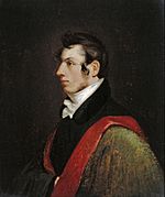
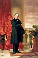
Samuel Morse, who lived at Locust Grove
-
Matthew Vassar, who helped start the college


- Bill Duke, an actor.
- Taylor Jardine, lead singer for the band We Are The In Crowd.
- Jeh Johnson, who served as the United States Secretary of Homeland Security.
- Johnny Miller, a pioneer in aviation.
- Lee Miller, a famous Vogue photographer and World War II correspondent.
- Samuel Morse, an American painter and inventor.
- Matthew Vassar, who helped found Vassar College.
Images for kids
-
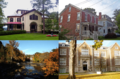
Clockwise from top left: Locust Grove, Stone Street Historic District, Vassar College, Red Oaks Mill
-
Official seal on display in town hall
-
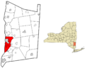
Location of the town of Poughkeepsie, New York
See also
 In Spanish: Poughkeepsie (pueblo) para niños
