
Princess Royal Island facts for kids

Princess Royal Island is located on the Inside Passage to the east of Hecate Strait
|
|
| Geography | |
|---|---|
| Location | North Coast Archipelago (Central Coast) |
| Coordinates | 52°55′N 128°50′W / 52.917°N 128.833°W |
| Area | 2,251 km2 (869 sq mi) |
| Administration | |
|
Canada
|
|
| Province | British Columbia |
| Region | North Coast |
| Demographics | |
| Ethnic groups | Tsimshian territory |
Princess Royal Island is the largest island on the North Coast of British Columbia, Canada. It is found among the many isolated inlets and islands east of Hecate Strait. This island is the fourth largest in British Columbia, covering about 2,251 square kilometers (870 square miles). Captain Charles Duncan named Princess Royal Island in 1788. He named it after his ship, the sloop Princess Royal.
Contents
Getting to Princess Royal Island
Princess Royal Island is in a very remote part of British Columbia. It is about 520 kilometers (323 miles) north of Vancouver. It is also about 200 kilometers (124 miles) south of Prince Rupert. You can only reach the island by boat or by air.
The Inside Passage is a popular ferry and shipping route. It runs along the island's eastern side. This route is in the Princess Royal Channel, which separates the island from the mainland.
Past Communities on the Island
Today, Princess Royal Island has no people living on it permanently. However, it used to be home to two communities. One was Surf Inlet, a town where people mined for gold. The other was Butedale, which was a town for mining, fishing, and logging.
The closest communities today are Klemtu on Swindle Island. There is also Hartley Bay, which is on the mainland shore.
What Animals Live on Princess Royal Island?
Princess Royal Island is a special place for wildlife. It is part of the Pacific temperate rain forest area. This means it has a lot of trees and gets a lot of rain.
Land Animals
Many interesting animals live on the island. These include the rare kermode bear, also known as the spirit bear. You can also find black bears and grizzly bears. Other animals include deer, wolves, and foxes.
Birds and Marine Life
The island is also home to many birds. You might see golden eagles and bald eagles nesting here. The endangered marbled murrelet also makes its home on the island.
The waters around Princess Royal Island are full of marine life. There are lots of salmon, elephant seals, orcas (killer whales), and porpoises.
Protecting the Environment
Princess Royal Island is a very important part of a large protected area. This area is known as the Great Bear Rainforest. Environmental groups work hard to keep this beautiful place safe.
History of Princess Royal Island
In 1950, something unusual happened near Princess Royal Island. A U.S. Air Force plane, a B-36 bomber, had an accident. Twelve of its 17 crew members were found alive on Princess Royal Island. The plane itself flew further north and crashed on Mount Kologet.
Images for kids
-
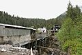
Cannery Ruins in Butedale

See also
 In Spanish: Isla Princesa Real para niños
