
Provincias Internas facts for kids
Quick facts for kids
Captaincy General of the Internal Provinces
Capitanía General de las Provincias Internas
|
|||||||
|---|---|---|---|---|---|---|---|
| 1776–1821 | |||||||
 Flag
|
|||||||
| Status | Captaincy General of Spain | ||||||
| Capital | Arizpe 1776-1787, Durango 1787-1821 (Western division) Monterrey 1787-1821 (Eastern division) |
||||||
| Religion | Roman Catholicism | ||||||
| Government | Monarchy | ||||||
| King | |||||||
|
• 1776–1788
|
Charles III | ||||||
|
• 1813–1821
|
Ferdinand VII | ||||||
| Captain General | |||||||
|
• 1776–1783
|
Teodoro de Croix | ||||||
| Historical era | Spanish Empire | ||||||
|
• Administrative reorganisation
|
1776 | ||||||
| 1821 | |||||||
|
|||||||
| Today part of | Mexico United States |
||||||
The Provincias Internas (pronounced: pro-VEEN-see-ahs een-TER-nas), also known as the Commandancy and General Captaincy of the Internal Provinces, was a special administrative area of the Spanish Empire. It was created in 1776 to give more control to the frontier (border) provinces of New Spain. This area included parts of what are now northern Mexico and the Southwestern United States.
The main goal was to create a single government for political, military, and money matters in this region. The Spanish wanted to make the area stronger and help its economy and population grow. This was also to stop other countries like Russia, France, the United Kingdom, and the new United States from trying to take over the land. The Provincias Internas included provinces like New Navarre, Nueva Vizcaya, Las Californias, Nuevo México, Nuevo Santander, Nuevo Reyno de León, Coahuila, and Texas.
Contents
History of the Internal Provinces
How the Provincias Internas Started
.svg)
The idea for the Provincias Internas came from José de Gálvez. He was a royal inspector in New Spain from 1761 to 1772. At first, he wanted to make the northern provinces a full viceroyalty (a large area ruled by a viceroy, who acts for the king). But the area didn't have many people and cost a lot to protect.
So, instead, the main official in charge was called a "commander general." This person was both the military leader and the main civil leader. The viceroys of New Spain didn't like this idea at first. But a few years later, Gálvez became the Minister of the Indies, a very powerful new job. From this position, he could make his plans happen.
King Charles III supported these changes, which were part of bigger reforms called the Bourbon Reforms. Gálvez chose Teodoro de Croix to be the first Commander General of the Provincias Internas.

The king wanted the new area to have a strong military command. This would help defend the northern provinces and encourage more people to settle there. The biggest threats were attacks and rebellions from native groups.
The king said that the Captaincy General would mostly answer directly to him, not to the Viceroy of New Spain. However, the Captain General still had to keep the viceroy informed about important news.
The first capital city was Arizpe, located in Sonora. This city was chosen because it was almost in the middle of the Californias and Nueva Vizcaya. Teodoro de Croix arrived in Mexico City in December 1776. He officially started his job in February 1777 and reached Arizpe in October 1779. He made Arizpe the capital on January 12, 1780.
Croix stayed in charge until August 1783. Then, Felipe de Neve took over until he died in August 1784.
Changes and Divisions
Over time, the Provincias Internas went through many changes. In 1786, the king decided that the Commandancy would be under the control of the viceroy, Bernardo de Gálvez. The capital was moved to Chihuahua.
The viceroy then divided the area into three military districts:
- One for Sonora, Sinaloa, and the Californias.
- Another for Coahuila, Nuevo Reyno de León, Nuevo Santander, and Texas.
- A third for Nueva Vizcaya and New Mexico.
However, when Viceroy Gálvez died in November 1786, the Captain General regained its independence from the new viceroy.
New Ways of Governing
As part of the Bourbon Reforms, King Charles III created twelve "intendencies" in New Spain in 1786. These new areas replaced older ways of governing. The Provincias Internas were affected by this. For example, the government of Nueva Vizcaya became the Intendency of Durango.
The Californias were not part of this new system at first. They remained under the direct control of the Captain General.
Splitting the Captaincy General
In March 1787, the king decided to split the Provincias Internas into two main parts for military reasons:
- Western Internal Provinces: This included Sonora, Sinaloa, Las Californias, Nueva Vizcaya, and Nuevo México. Arizpe was its capital.
- Eastern Internal Provinces: This included Texas, Nuevo León, Nuevo Santander, and Coahuila. Santa Rosa (now Múzquiz) was its capital.
The viceroy had limited power over these two new areas. But in March 1788, the king gave the viceroy full power over them again.
Reuniting and Dividing Again
In November 1790, King Charles IV ordered that the Captaincy General be reunited and made independent from the viceroy. But this changed again in 1791 and 1792, putting it back under the viceroy's control.
In 1793, Pedro Nava became the Captain General and was independent from the viceroy. He moved the capital to Chihuahua. Some provinces, like Californias and Nuevo León, were placed under military governors who reported directly to the viceroy.
In 1804, the king ordered the division into East and West again, but it didn't happen right away. In 1811, the division was finally made. Joaquín de Arredondo became the commander for the East, and Bernardo Bonavia y Zapata for the West.
The Spanish American wars of independence began in 1810. In 1811, a rebel leader tried to spread the fight to the Internal Provinces but was defeated.
In 1812, the Constitution of Cadiz was approved. This constitution divided the Spanish territories in North America into provinces with "Special political Governors." It created:
- The Provincial Government of the Eastern Internal Provinces based in Monterrey.
- The Provincial Government of the Western Internal Provinces based in Durango.
However, King Ferdinand VII canceled the Constitution in 1814. It was brought back in 1820 due to a revolution in Spain.
In 1819, the Adams–Onís Treaty was signed between Spain and the United States. This treaty set the border between the Internal Provinces and the U.S. It confirmed that Texas and lands up to the Oregon Territory belonged to Spain.
The Provincias Internas came to an end in 1821 as Mexico gained its independence from Spain. The leaders in the East and West joined the movement for independence, and Spanish rule in northern New Spain ended.
Life in the Provincias Internas
The Provincias Internas received money from the royal treasury in Mexico City to help pay for their needs. The first capital was Arizpe in Sonora. The provinces in this new district were different from the southern parts of New Spain.
In the south, there were complex, settled societies like the Mexica and Zapotec. But in the more dry northern region, there were mostly semi-nomadic peoples. The Spanish called them Chichimeca. These groups often resisted Spanish settlers. Over time, some were pushed off their lands, while others mixed into a new Hispanic culture. This new culture grew in the towns and cities near the many silver mines that attracted European settlers from Spain and other Catholic parts of Europe.
In the northern Provincias Internas, there were often fights between Spanish settlers (and later Mexican citizens) and native peoples. This continued even after Mexico became independent. The German scientist Alexander von Humboldt wrote about this in 1811. He noted that living in this region made people strong and active. They had to constantly protect themselves, their homes, and their families from attacks by wandering native groups. He also mentioned that the climate was good, and people had to work hard because the land wasn't always rich.
Some native groups, like the Coahuiltecans, disappeared by the mid-1800s. This was due to being forced from their lands, diseases, and wars against settlers and other native groups. Mixing of different racial groups (called Mestizaje) was less common here than in other parts of New Spain. Many native groups did not want to become Catholic or join Hispanic society. People of different backgrounds often lived separately.
Humboldt also noted that by 1810, people of Spanish and Criollo (people of Spanish descent born in the Americas) backgrounds made up most of the population. This was because more Spanish settlers arrived, and the number of native peoples decreased greatly due to disease and conflict.
Population Numbers
Here's a look at the population of the Provincias Internas in 1790, based on a census by Revillagigedo:
| Province/Territory | Pop Spaniards/Criollo 1790 | % pop 1790 | Mestizo, Castizo and other castes 1790 | % pop 1790 | Indians 1790 | % pop 1790 | Total Population | Inhabitants per Sq.League |
|---|---|---|---|---|---|---|---|---|
| Eastern Internal Provinces | ||||||||
| New Kingdom of León | 27,412 | 63% | 13,838 | 32% | 2,431 | 5% | 43,739 | 17 |
| New Santander | 14,639 | 26% | 28,825 | 51% | 13,251 | 23% | 56,715 | 11 |
| Coahuila or New Extremadura | 13,285 | 32% | 17,215 | 40% | 12,411 | 28% | 42,937 | 6 |
| Texas | 1,326 | 41% | 1,083 | 32% | 912 | 27% | 3,334 | N/A |
| Western Internal Provinces | ||||||||
| Durango | 35,992 | 21% | 77,302 | 43% | 63,890 | 36% | 177,400 | 10 |
| New Navarre | 38,640 | 29% | 35,766 | 26% | 60,855 | 44% | 135,385 | 7 |
| New Mexico | Unknown | -% | 23,628 | -% | 10,557 | -% | - | - |
| Californias | ||||||||
| Old or Lower (Baja) | Unknown | - | 2,325 | - | 2,153 | - | 4,496 | - |
| New or Upper (Alta) | Unknown | - | 18,780 | - | 2,052 | - | 20,871 | 10 |
Images for kids
-
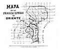
Map of the Eastern Internal Provinces created by Joaquín de Arredondo.
-
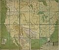
1817 Spanish Map of the Internal Provinces of New Spain.


See also
 In Spanish: Comandancia General de las Provincias Internas para niños
