
Ragged Top facts for kids
Quick facts for kids Ragged Top |
|
|---|---|

Northeast aspect
|
|
| Highest point | |
| Elevation | 3,907 ft (1,191 m) |
| Prominence | 1,347 ft (411 m) |
| Isolation | 2.40 mi (3.86 km) |
| Parent peak | Silver Bell Benchmark |
| Geography | |

Ragged Top
Location in Arizona

Ragged Top
Location in the United States
|
|
| Location | Ironwood Forest National Monument Pima County, Arizona, U.S. |
| Parent range | Silver Bell Mountains |
| Topo map | USGS Silver Bell East |
| Geology | |
| Age of rock | Cretaceous to Tertiary |
| Mountain type | volcanic plug |
| Type of rock | Rhyolite |
| Climbing | |
| Easiest route | class 3 scrambling |
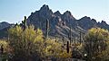
Ragged Top is a mountain peak in southern Arizona. It stands about 3,907 feet (1,191 meters) tall. This mountain is found inside the Ironwood Forest National Monument. It is located in Pima County, about 35 miles northwest of Tucson. Ragged Top is part of the Silver Bell Mountains. It rises more than 1,700 feet (518 meters) above the land around it. This makes it a very noticeable landmark.
Contents
What Makes Ragged Top Special?
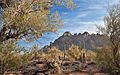
Ragged Top is a very important place for nature lovers. It is known for its beautiful views and amazing wildlife. You can see animals like the Desert bighorn sheep and the desert tortoise here.
Rich Plant Life
This mountain has the most different kinds of plants in the entire Sonoran Desert. There are 401 different plant species found here. One special plant, called Cathestecum erectum (also known as false grama), grows only on Ragged Top in all of Arizona. The lower slopes around the mountain are covered with forests of giant Saguaro cacti and ironwood trees. The mountain is also part of the Gila River water system. You can even find four small natural arches on Ragged Top.
How Ragged Top Was Formed
Ragged Top is a type of mountain called a volcanic plug. This means it was formed from hardened lava that once filled the vent of an ancient volcano. Over a very long time, the softer rock around it wore away. This left the harder volcanic rock standing tall. The rock that makes up Ragged Top is called Rhyolite. It formed a long, long time ago, between the Cretaceous and Tertiary periods.
Climate Around Ragged Top
The area around Ragged Top has a hot desert climate. This means it is usually very warm and dry. It does not get much rain throughout the year.
| Climate data for Silver Bell Mountains | |||||||||||||
|---|---|---|---|---|---|---|---|---|---|---|---|---|---|
| Month | Jan | Feb | Mar | Apr | May | Jun | Jul | Aug | Sep | Oct | Nov | Dec | Year |
| Mean daily maximum °F (°C) | 63 (17) |
66 (19) |
71 (22) |
79 (26) |
88 (31) |
98 (37) |
98 (37) |
96 (36) |
93 (34) |
84 (29) |
72 (22) |
62 (17) |
81 (27) |
| Mean daily minimum °F (°C) | 43 (6) |
46 (8) |
49 (9) |
55 (13) |
63 (17) |
72 (22) |
74 (23) |
72 (22) |
70 (21) |
61 (16) |
51 (11) |
43 (6) |
58 (14) |
| Average precipitation inches (mm) | 0.9 (23) |
0.9 (23) |
0.8 (20) |
0.2 (5.1) |
0.2 (5.1) |
0.3 (7.6) |
2.5 (64) |
2.5 (64) |
1.3 (33) |
1 (25) |
0.8 (20) |
1.3 (33) |
12.8 (330) |
| Source: Weatherbase | |||||||||||||
Images for kids
-
-
West aspect
-
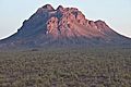
North aspect


