
Recherche Archipelago facts for kids


.jpeg)

The Archipelago of the Recherche, also called the Bay of Isles, is a group of 105 islands. It also has over 1200 "obstacles to shipping" (like rocks and reefs). These islands are found off the south coast of Western Australia.
The islands stretch about 230 kilometres (140 miles) from east to west. They are up to 50 kilometres (30 miles) away from the shore. The total area of the archipelago is about 4,000 square kilometres (1,500 sq mi).
The islands are divided into two main groups. The western group is close to Esperance. The eastern group is near Israelite Bay. The coastal waters around the islands are part of the Recherche Archipelago Nature Reserve.
Contents
History of the Archipelago
Ancient History: Before Europeans Arrived
People lived on these islands a very long time ago, about 13,000 years ago. Scientists have found old tools and other items on Salisbury Island. This island is a huge limestone rock sitting on a granite dome. It is about 60 kilometres (37 miles) offshore.
The items found include stone blades, lizard traps, and axe heads. There were also grinding stones and granite watering holes. These objects are thought to be from a time when sea levels were much lower. Back then, many of the islands were connected to the mainland.
European Discovery and Naming
Europeans first learned about these islands in 1627. This was when François Thijssen and Pieter Nuyts sailed past on their ship, Gulden Zeepaert. Later, George Vancouver also sailed through the islands in 1791 on his ship, HMS Discovery.
The islands were named "Archipelago of the Recherche" by Rear-admiral Bruni d'Entrecasteaux in 1792. He was a French explorer looking for another lost navigator, Jean-François de Galaup, comte de Lapérouse. The name came from one of the admiral's ships, the Recherche. The bay where Esperance is now was named after his other ship, the Espérance.
Matthew Flinders was the first person to fully explore and map the islands. He did this in 1802 during his journey on the HMS Investigator.
Maritime Events and Shipwrecks
In 1803, Matthew Flinders left two anchors behind at Middle Island. Divers found and recovered these anchors in 1973. One anchor is now at the South Australian Maritime Museum. The other can be seen at the National Museum of Australia.
Sailors and whalers from other British colonies in Australia visited this area from the early 1820s. Black Jack Anderson, Australia's only recorded pirate, used the archipelago as his base in the 1830s. He was a former whaler who became a pirate and caused a lot of trouble before his own crew killed him.
Middle Island was an important place for hunting right whales in the 1830s and 1840s.
Many shipwrecks have happened around the archipelago. For example, the ship Belinda was wrecked off Middle Island in 1824. The SS Penguin also sank off Middle Island in 1920 during a storm. On February 14, 1991, the Sanko Harvest, a huge cargo ship, sank here. It became the second-largest shipwreck in the world that divers can explore.
Today, people use the area for fun activities like fishing. Commercial fishing also takes place, catching abalone, southern rock lobsters, and sharks. Shipping from the Port of Esperance also uses these waters. There are also plans to farm fish like bluefin tuna here.
Geography of the Islands
The archipelago has 105 islands and more than 1,500 smaller islets. All the islands together cover an area of about 9,720 hectares (24,000 acres).
Most of the islands are made of granite rocks. They often have steep sides and usually do not have sandy beaches. Many features are underwater and only appear when the tides are low.
The coast here experiences some of the strongest waves in Australia. These waves can cause erosion up to 100 metres (330 feet) deep during storms. The inner part of the archipelago is about 40 metres (130 feet) deep on average. Most of the islands are in waters about 60 metres (200 feet) deep. Middle Island is the largest island in the archipelago, covering 1,080 hectares (2,700 acres).
Island Groups


The islands are usually split into two groups. The western group is near Esperance, Woody Island, and Cape Le Grand National Park. The eastern group is where Middle Island is, close to Cape Arid National Park.
Some studies divide the islands even further into smaller groups. These include the Woody Group and the Remark Group.
Part of this area is called the 'Recherche subregion'. It includes Cape Le Grand National Park in the west and Cape Arid National Park in the east. This whole area is known as the Recherche Archipelago Nature Reserve.
Notable Islands
In 1973, a tour operator named Don MacKenzie was allowed to bring visitors to Woody Island. His family built the jetty that visitors still use today.
| Name | Location | Area (ha) | Notes |
|---|---|---|---|
| Anvil Island | 33°44′17″S 124°05′39″E / 33.73806°S 124.09417°E | 38 | A resting place for Australian sea lions. |
| Barrier Island | 33°58′48″S 123°08′13″E / 33.98000°S 123.13694°E | 10 | Protects beaches near Cape Arid. Also a resting place for Australian sea lions. |
| Beaumont Island | 34°05′25″S 122°32′22″E / 34.09028°S 122.53944°E | 36 | May be a breeding site for Australian sea lions. |
| Bellinger Island | 33°53′09″S 123°38′36″E / 33.88583°S 123.64333°E | 38 | May be a breeding site for Australian sea lions. The ship Mary Ann was wrecked here in 1876. |
| Ben Island | 33°54′01″S 122°45′12″E / 33.90028°S 122.75333°E | 30 | Used for scientific research. |
| Boxer Island | 34°00′02″S 121°40′42″E / 34.00056°S 121.67833°E | 162 | A resting place for Australian sea lions. |
| Capps Island | 33°59′19″S 121°40′55″E / 33.98861°S 121.68194°E | 35 | A resting place for Australian sea lions. |
| Canning Island | 33°55′05″S 121°46′20″E / 33.91806°S 121.77222°E | 16 | Home to 2000-3000 pairs of white-faced storm-petrel birds. |
| Charley Island | 33°55′23″S 121°52′31″E / 33.92306°S 121.87528°E | 83 | Has a small group of bush rats. |
| Cooper Island | 34°13′55″S 123°36′22″E / 34.23194°S 123.60611°E | 42 | A breeding site for Australian sea lions and New Zealand fur seals. |
| Corbett Island | 34°07′05″S 121°58′40″E / 34.11806°S 121.97778°E | 84 | A resting place for Australian sea lions. |
| Cranny Island | 33°43′51″S 124°04′40″E / 33.73083°S 124.07778°E | 4 | A resting place for Australian sea lions. |
| Cull Island | 33°55′22″S 121°54′07″E / 33.92278°S 121.90194°E | 68 | Home to about 30 Cape Barren geese. |
| Daw Island | 33°50′45″S 124°08′02″E / 33.84583°S 124.13389°E | 206 | May be a breeding site for Australian sea lions. Has a small group of bush rats. |
| Draper Island | 34°11′45″S 122°29′45″E / 34.19583°S 122.49583°E | 20 | A resting place for Australian sea lions. |
| Figure of Eight Island | 34°01′37″S 121°36′25″E / 34.02694°S 121.60694°E | 233 | May be a breeding site for Australian sea lions. |
| Finger Island | 34°06′17″S 122°20′38″E / 34.10472°S 122.34389°E | May be a breeding site for Australian sea lions. | |
| Frederick Island | 34°04′02″S 122°00′19″E / 34.06722°S 122.00528°E | 77 | Supports 500-1000 pairs of flesh-footed shearwaters and 5000-8000 pairs of white-faced storm-petrels. |
| Glennie Island | 34°05′45″S 123°06′18″E / 34.09583°S 123.10500°E | May be a breeding site for Australian sea lions. | |
| Gulch Island | 34°01′31″S 123°14′50″E / 34.02528°S 123.24722°E | This granite island is about 2 kilometres (1.2 miles) long and 20 metres (66 feet) high. It is about 3 kilometres (1.9 miles) offshore from beaches west of Cape Arid. | |
| Halfway Island | 33°46′12″S 124°02′24″E / 33.77000°S 124.04000°E | May be a breeding site for Australian sea lions. Also known as Ford Island. | |
| Hasler Island | 34°07′01″S 123°04′01″E / 34.11694°S 123.06694°E | A resting place for Australian sea lions. | |
| Hastings Island | 34°06′05″S 122°07′01″E / 34.10139°S 122.11694°E | A resting place for Australian sea lions. | |
| Hector Island | 34°00′00″S 121°43′01″E / 34.00000°S 121.71694°E | A resting place for Australian sea lions. | |
| Helby Island | 34°07′01″S 123°04′01″E / 34.11694°S 123.06694°E | A resting place for Australian sea lions. | |
| High North Island | 33°43′01″S 124°05′59″E / 33.71694°S 124.09972°E | A resting place for Australian sea lions. | |
| Hood Island | 34°08′34″S 122°02′53″E / 34.14278°S 122.04806°E | 131 | Has a small group of bush rats. |
| Hope Island | 34°04′44″S 122°09′46″E / 34.07889°S 122.16278°E | A resting place for Australian sea lions. | |
| Hugo Island | 34°08′42″S 122°19′01″E / 34.14500°S 122.31694°E | A resting place for Australian sea lions. | |
| Kermadec Island | 34°05′16″S 122°50′02″E / 34.08778°S 122.83389°E | Also known as Wedge Island. A breeding site for Australian sea lions. | |
| Little Island | 34°27′25″S 121°59′23″E / 34.45694°S 121.98972°E | A breeding site for Australian sea lions. | |
| Long Island | 34°02′57″S 121°57′42″E / 34.04917°S 121.96167°E | 138 | Home to hundreds of flesh-footed shearwaters. |
| Lorraine Island | 33°57′00″S 122°33′46″E / 33.95000°S 122.56278°E | 9 | Home to 2000-3000 pairs of white-faced storm-petrels. |
| MacKenzie Island | 34°12′01″S 122°06′43″E / 34.20028°S 122.11194°E | 48 | A breeding site for Australian sea lions. |
| Manicom Island | 34°07′01″S 123°01′58″E / 34.11694°S 123.03278°E | A resting place for Australian sea lions. | |
| Middle Island | 34°05′58″S 123°11′23″E / 34.09944°S 123.18972°E | 1080 | This is the largest island in the archipelago. D'Entrecasteaux named it. Matthew Flinders visited in 1802 and climbed Flinders Peak (185 metres/607 feet) to map the islands. The island has a pink lake called Lake Hillier. The pirate, Black Jack Anderson, used this island as his base. The Belinda was wrecked here in 1824, and the SS Penguin in 1920. The island has tammar wallabys and bush rats. It is 6.5 kilometres (4.0 miles) long and about 9 kilometres (5.6 miles) offshore from Cape Arid. |
| Mondrain Island | 34°08′14″S 122°14′45″E / 34.13722°S 122.24583°E | 810 | Home to Recherche rock-wallabies, black-flanked rock-wallabys, and bush rats. Its highest point is Baudin Peak (222 metres/728 feet). |
| Nares Island | 33°56′01″S 122°35′35″E / 33.93361°S 122.59306°E | 6 | Known to have 3-4 pairs of white-faced storm-petrels. |
| New Year Island | 33°51′21″S 124°07′37″E / 33.85583°S 124.12694°E | A resting place for Australian sea lions. | |
| Nook Island | 33°46′22″S 124°05′59″E / 33.77278°S 124.09972°E | A breeding site for Australian sea lions. | |
| North Twin Peak Island | 33°59′27″S 122°50′18″E / 33.99083°S 122.83833°E | Has a small group of bush rats. | |
| Observatory Island | 33°55′27″S 121°47′31″E / 33.92417°S 121.79194°E | 101 | Captains Bruni d’Entrecasteaux and Huon de Kermandec found shelter here in 1792 during a big storm. The island has a colony of 20-30 pairs of little penguins. |
| Pasley Island | 34°00′39″S 123°31′55″E / 34.01083°S 123.53194°E | Also known as Paisley Island. May be a breeding site for Australian sea lions. | |
| Passage Island | 33°58′58″S 122°25′58″E / 33.98278°S 122.43278°E | A resting place for Australian sea lions. | |
| Pearson Island | 34°13′01″S 122°20′59″E / 34.21694°S 122.34972°E | A resting place for Australian sea lions. | |
| Ram Island | 34°01′55″S 122°08′29″E / 34.03194°S 122.14139°E | 142 | Home to a colony of 300-500 pairs of flesh-footed shearwaters. |
| Red Island | 33°52′15″S 121°20′59″E / 33.87083°S 121.34972°E | A resting place for Australian sea lions. | |
| Remark Island | 34°03′52″S 121°59′03″E / 34.06444°S 121.98417°E | 101 | Ten nests of the black-faced cormorant bird are found here. |
| Rocky Island | 34°04′58″S 120°52′01″E / 34.08278°S 120.86694°E | A breeding site for Australian sea lions. | |
| Rodonia Island | 33°49′58″S 123°55′01″E / 33.83278°S 123.91694°E | A resting place for Australian sea lions. | |
| Round Island | 34°06′17″S 123°53′16″E / 34.10472°S 123.88778°E | A breeding site for Australian sea lions. | |
| Salisbury Island | 34°21′39″S 123°33′01″E / 34.36083°S 123.55028°E | 320 | A breeding ground for the Australian fur seal and the New Zealand fur seal. Also home to black-flanked rock-wallabys and bush rats. |
| Sandy Hook Island | 34°02′04″S 121°59′32″E / 34.03444°S 121.99222°E | 285 | Flesh-footed shearwater birds are common on this island. |
| Slipper Island | 34°02′45″S 122°45′10″E / 34.04583°S 122.75278°E | May be a breeding site for Australian sea lions. | |
| Stanley Island | 34°01′02″S 123°17′27″E / 34.01722°S 123.29083°E | Also known as Wickham Island. A breeding site for Australian sea lions. | |
| Tadpole Island | 33°43′58″S 124°01′58″E / 33.73278°S 124.03278°E | A resting place for Australian sea lions. | |
| Taylor Island | 33°55′17″S 122°52′17″E / 33.92139°S 122.87139°E | A breeding site for Australian sea lions. | |
| Termination Island | 34°28′15″S 121°59′31″E / 34.47083°S 121.99194°E | May be a breeding site for Australian sea lions. | |
| Tizard Island | 34°01′01″S 122°40′58″E / 34.01694°S 122.68278°E | A resting place for Australian sea lions. | |
| Westall Island | 34°04′50″S 122°58′03″E / 34.08056°S 122.96750°E | 70 | Home to Recherche rock-wallabies and black-flanked rock-wallabys. |
| Wickham Island | 34°01′16″S 123°17′23″E / 34.02111°S 123.28972°E | ||
| Wilson Island | 34°06′57″S 121°59′40″E / 34.11583°S 121.99444°E | 90 | Home to Recherche rock-wallabies and black-flanked rock-wallabys. |
| Woody Island | 33°57′43″S 122°00′40″E / 33.96194°S 122.01111°E | 188 | This is the only island in the reserve that the public can visit. |
Plants and Animals of the Archipelago
The Recherche Archipelago is a special place for plants and animals. It has a very high number of different species that live only in this region. This is partly because of the Leeuwin Current. This warm ocean current flows east, making the sea temperature over 20°C (68°F) in summer.
Larger islands have soil and rocks that support plants, nesting birds, and other animals. The waters around the islands are also full of life. The seafloor has different amounts of seagrass meadows, reefs, or bare sand.
Marine Life
The waters around the islands meet steep granite cliffs. The many reefs and other features create homes for a rich variety of marine life. This includes 263 known types of fish and 347 types of molluscs (like snails and clams). There are also over 450 kinds of sponges, sea grasses, and soft corals.
A special coral-like algae called rhodoliths forms beds. These beds support marine spiders, snails, and worms. They also act as a safe place for young scallops to grow. Marine mammals found near the islands include two types of seals. Large groups of common dolphins and minke whales also visit.
Land Animals
The islands are home to many land plants and animals. Some of these are found only in the archipelago.
New Zealand fur seals and Australian sea lions have breeding colonies on some islands. Many islands also have places where these seals can rest.
Marsupials (pouched mammals) found here include tammars and a type of bandicoot. There are also two kinds of rock wallabies.
Snakes found on the islands include the Recherche Island dugite on Cull Island. Other reptiles include the barking gecko, ornate dragon, and the southern heath monitor. Two types of frogs also live on the islands: the quacking frog and the spotted-thighed frog.
Many of these animals and plants are in refugia. This means they are safe from things that threaten similar groups on the mainland.
Birds and Their Reproduction
BirdLife International has named the archipelago an Important Bird Area (IBA). This is because it is the only place where the western subspecies of the Cape Barren goose, called the Recherche Cape Barren goose, breeds.
The islands also support over 1% of the world's population of flesh-footed shearwaters, sooty oystercatchers, fairy terns, and likely white-faced storm-petrels. Rock parrots and red-eared firetails have also been seen here.
Gallery
-
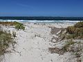
Recherche Archipelago from Castletown Beach in Esperance
-
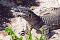
A Rosenberg's monitor lizard found on the Archipelago
-
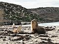
Australian sea lions are common on islands of the Archipelago
-
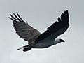
A White-bellied sea eagle flying over the Recherche Archipelago, Esperance

.jpg)


See also
 In Spanish: Archipiélago de La Recherche para niños
