
Red Clay State Park facts for kids
Quick facts for kids Red Clay State Historic Park |
|
|---|---|

Eternal Flame of the Cherokee Nation
|
|
| Type | Tennessee State Park |
| Location | Bradley County, Tennessee |
| Area | 263 acres (1.06 km2) |
| Open | year round |
|
Red Clay Council Ground
|
|
| Lua error in Module:Location_map at line 420: attempt to index field 'wikibase' (a nil value). | |
| Nearest city | Cleveland, Tennessee |
| Area | 150 acres (61 ha) |
| Website | Red Clay State Park |
| NRHP reference No. | 72001229 |
| Added to NRHP | September 14, 1972 |
Red Clay State Historic Park is a special state park in southern Bradley County, Tennessee. It opened in 1979. This park is also known as a stop on the Cherokee Trail of Tears. It covers about 263 acres (1.06 km2) of land. The park is located right near the line between Tennessee and Georgia.
Red Clay was the last place where the Cherokee national government met. This was before 1838, when the U.S. military enforced the Indian Removal Act of 1830. This act forced most of the Cherokee people in the area to move west. Eleven big meetings were held at Red Clay between 1832 and 1838.
Before it was a government meeting place, the Cherokee used this site for many important ceremonies. This was because of its famous spring, called the Blue Hole Spring. The Cherokee people still see this place as sacred ground.
Contents
History of Red Clay
The Cherokee and Red Clay
Long before European settlers arrived, this area was part of the Cherokee Nation. After 1819, the Cherokee government moved its main office. It went to a place near what is now Charleston. Laws in Georgia made it hard for the Cherokee to hold public meetings. Also, the U.S. government passed the Indian Removal Act. Because of these things, the Cherokee started to leave their capital in New Echota. In 1832, they officially moved their government to Red Clay.
Between 1832 and 1838, eleven large meetings were held at Red Clay. About 4,000 to 5,000 Cherokees attended each meeting. During these meetings, the Cherokee leaders kept saying no. They refused to give up their lands east of the Mississippi River. They did not want to move west.
A Difficult Time
On December 29, 1835, a small group of Cherokees signed the Treaty of New Echota. The main Cherokee Council at Red Clay did not approve this treaty. But it said the Cherokee would give up their lands east of the Mississippi River. It also said they would move to what is now Oklahoma.
In February 1836, two more meetings happened. One was at Red Clay and another in North Carolina. They made lists of about 13,000 Cherokees who were against the treaty. These lists were written in the Sequoyah writing system. Chief John Ross sent them to Washington, D.C. He showed them to Congress.
However, a slightly changed version of the treaty was approved. The U.S. Senate passed it by just one vote on May 23, 1836. Then-President Andrew Jackson signed it into law. The treaty gave the Cherokees until May 1838 to move on their own.
The U.S. military used the office in Charleston as its main base for the forced removal. Many temporary camps were set up in northern Bradley County. Two of the biggest were at Rattlesnake Springs. The Cherokee removal, known as the Trail of Tears, officially began at Red Clay.
Creating the Park
Later in the 1900s, people wanted to save the Red Clay Council Ground. It was private land then. Local historians led the effort to turn it into a state park. The Council Grounds were added to the National Register of Historic Places (NRHP) on September 14, 1972. The state of Tennessee bought the land for the park in 1974.
The site became a state park on May 8, 1976. Members of the Eastern Band of Cherokee Indians attended the ceremony. Local and state leaders were also there. Work on the park began on April 26, 1978. Red Clay State Park opened to the public on September 28, 1979. A small piece of land was added to the park in 1980.
The Eternal Flame was placed at the site on April 6, 1984. Both the Eastern and Western Bands of the Cherokee attended this event. It was the first time all three tribes had been together since the forced removal.
What You Can See at the Park

Red Clay State Park covers about 263 acres (1.06 km2). It has a copy of a Cherokee farmstead. There is also a replica of the council house. This is where the last Cherokee council meeting happened before the removal.
Important Places
The Eternal Flame of the Cherokee Nation is also at the park. It is a memorial to the Cherokees who suffered during the removal. This flame is always kept lit. The park also has the famous Blue Hole Spring. It is also called the Council Spring. The Cherokee people thought this spring was sacred. The spring comes out of a bowl-shaped dip. It is called "Blue Hole" because of its deep blue color. Its water flows into Coahulla Creek. This creek then goes into the Conasauga River. About 414,720 gallons of water flow from the spring each day.
The grave of Sleeping Rabbit is said to be in the eastern part of the park. He was an important Cherokee who fought in the War of 1812. However, his grave does not have a marker.
Exploring the Park
The park has three trails for walking. The Connector Trail is about 0.15 miles (0.24 km) long. The Blue Hole Trail is about 0.2 miles (0.32 km) long. The Council of Trees Trail is about 1.7 miles (2.7 km) long. This last trail has a tower where you can look out over the park. The border between Tennessee and Georgia is the southern edge of the park.
The James F. Corn Interpretive Center has displays about Cherokee culture. You can learn about their government, economy, and history from the 1700s and 1800s. There are also stained glass windows. They show the story of the forced removal of the Cherokee. You can also watch a video about the Cherokee people.
Each year in August, the Cherokee Cultural Celebration is held at the park. The Eastern Band of Cherokee Indians helps put on this event. It features displays about Cherokee culture and heritage.
Other interesting Cherokee places nearby include the cabin of Chief John Ross. It is in Rossville, Georgia. The grave of Nancy Ward is in Benton, Tennessee.
Images for kids
-
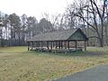
A replica of the Council House at Red Clay State Park
-
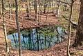
The iconic Blue Hole Spring, which was considered sacred to the Cherokees
-
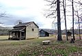
A replica of a Cherokee farmstead showing a farmhouse, barn, and corncrib


