Redhill, Somerset facts for kids
Quick facts for kids Redhill |
|
|---|---|
 Redhill village and church |
|
| Population | 308 (2011 census) |
| OS grid reference | ST495633 |
| Civil parish |
|
| Unitary authority | |
| Ceremonial county | |
| Region | |
| Country | England |
| Sovereign state | United Kingdom |
| Post town | BRISTOL |
| Postcode district | BS40 |
| Dialling code | 01934 |
| Police | Avon and Somerset |
| Fire | Avon |
| Ambulance | Great Western |
| EU Parliament | South West England |
| UK Parliament |
|
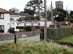
Redhill is a small village located at the base of a hill that shares its name. This hill, which is 173 meters (568 feet) tall, lies to the east and northeast of the village. Redhill is part of the civil parish of Wrington in North Somerset, England. It is situated along the A38 Bridgwater-Bristol Road. The village is about 8 miles (13 km) southwest of Bristol and very close to Bristol Airport.
Contents
Exploring Redhill's Past
The name "Redhill" first appeared on a map of Somerset in 1782. It might come from the red color of the dirt road leading up the hill, which had deep ruts from carts. Another idea is that the name means "Roe Hill" or "Roe Hollow," referring to the roe deer that still live in the area. Some believe the name comes from "Ragiol," a village mentioned in the Domesday Book of 1086. However, this is more likely to be Regil or Ridgehill.
Ancient Times in Redhill
Redhill has at least three very old structures from prehistoric times. There were once six barrows (ancient burial mounds) here, though they are now less than 3 feet (91 cm) high. A nearby long barrow is only about 2 feet (61 cm) high.
You can also find the remains of a burial chamber just south of Bristol Airport. Most of the mound is gone, but a large cover stone remains. This stone has a hollow that collects rainwater, which is why it's called "The Water Stone."
Just south of the village, in a deep hollow, is Lye Hole. Here, a stream flows into the Congresbury Yeo river. In July 1876, the remains of a Roman villa were discovered at Lye Hole. Around the villa, there are old field systems, which are long and narrow, about 30 meters (98 feet) wide. This area was a settlement during the late Roman or Roman-Saxon period.
Saxon and Medieval Periods
By the late Saxon period and at the time of the Norman Conquest in 1066, the area now known as Redhill was part of the Manor of Wrington. It included two main areas: Lye Hole to the east and Broadfield Down to the west.
In the mid-13th century, records show that 104 people lived on the manor, each holding between 3 and 40 acres (1.2 and 16.2 ha) of land. There were also eight cottagers with gardens, three millers, one priest, and four freeholders. Small enclosed fields, called "crofts" or "closes," were found near farms on Broadfield Down and in the Lye Cross and Lye Hole areas.
In the mid-16th century, Calamine, a zinc ore, was discovered at Broadfield Down. This ore was then taken down the Banwell River and shipped across the Bristol Channel to Tintern for smelting. Mining became faster in the 17th century with the use of gunpowder. Iron ore was also found during excavations in the 1970s. Ore processing often used washing and settling ponds called "buddles." Lye Hole Farm was sometimes called "the Washing Pool" or "at the Buddles." There is still a field on Lye Hole Farm called 'Uddles,' which has a spring.
How Redhill Grew
The A38 has been a major route between Bristol and the South West of England since medieval times. It might even be much older, possibly linking Roman settlements. Before the 18th century, local roads were in poor condition. Attempts to improve the Bridgwater Road (A38) with Turnpike Trusts began in 1727, but faced local opposition. However, an Act for Bristol was eventually passed.
John Macadam became Surveyor to the Bristol Turnpike Trust in 1816. His new method of building roads with crushed stone and tar was quickly adopted. Inns like The Bell Inn (later the Darlington Arms) provided places for horses to rest and change.
The center of Redhill village grew around the crossroads of Church Road, Winters Lane, Long Lane, and The Pound. "The Pound" was named because drovers (people who moved livestock) would keep their animals there overnight on their way to market in Bristol. Winters Lane is thought to have been the main road of Redhill, leading to an ancient settlement in Goblin Combe. This lane was also called "The Old Drove Road" and is still known as "Cooks Bridle Path" further along. It was an unpaved road until the 1920s.
Many houses in Redhill were built in the 20th century, but some farms are much older. Goblin Combe Farm dates back to 1858, and Scars Farm was built in 1884. Worship Farm was built in the 19th century, and Quarry Farm around 1900.
The Redhill Village Hall was built in 1911. The land and funds were a gift from Mr Henry Herbert Wills (from the W. D. & H. O. Wills tobacco family), and villagers furnished it. The Village Store used to be at "Banwells," across from the Darlington Arms. A branch of the County Library opened at the school in 1938, later replaced by a mobile library van. Redcroft, a street off Winters Lane, has six houses and a parsonage, all built around 1910 or 1911 for estate workers. Ashford Road, built in the 1930s, was originally planned for 60 houses, but most were never built.
Redhill During World War II
During World War II, children and families from London and Bristol were sent to live in Redhill to escape bombing. The village hall was used as a shelter during Bristol air raids and as the headquarters for the local Home Guard.
Early in the war, the War Office took over farmland on Broadfield Down to build a Royal Air Force (RAF) station. This station was used throughout the war. In 1956, Bristol City Council bought the land, and it became what is now Bristol Airport.
After the Second World War, Redhill gained electricity and mains water. Redacre, a street with six houses and bungalows, was built in 1964–65.
Local Government
The Wrington parish council manages local matters in Redhill. This includes setting a local tax to cover costs and reviewing planning applications. The council also works with the police and neighbourhood watch groups on crime, security, and traffic. They also start projects to maintain village facilities like the village hall or community centre, playing fields, and playgrounds. The council also talks with the district council about roads, drainage, footpaths, public transport, and street cleaning. They also care about conservation and environmental issues.
Redhill is part of the unitary authority of North Somerset, which was created in 1996. Before that, from 1974 to 1996, it was part of the Woodspring district of the county of Avon. Before 1974, the parish was part of the Axbridge Rural District.
The parish is represented in the House of Commons of the Parliament of the United Kingdom. It is part of the North Somerset constituency. Voters elect one Member of Parliament (MP) using the first past the post system. Currently, the MP is Liam Fox from the Conservative Party.
Redhill's Geography
At the foot of Sutton Hill, a small brook begins. It flows past Lye Hole and Cowslip Green before joining the River Yeo near Perry Bridge on the A38 Bridgwater Road.
Education in Redhill
There was likely a school at Broadfield from the late 18th century. An old cottage, now gone, was called "The Old School House." Fees were one penny a week. This dame school was run by Mrs. Saunders for 19 years until a new school was built in 1874.
The new school, built in 1874, cost £811.12s 6d, plus £50 for the architect. The Bishop of Bath and Wells opened it. The Duke of Cleveland, who owned most of Wrington Parish, donated the land. School numbers changed over the years, from 105 students in 1879 to 17 in 1937. By 1927, it had become a Junior School. The classrooms were heated by tortoise stoves until night storage heaters arrived. Redhill School celebrated its 100th anniversary in 1975. However, due to fewer children of school age, the school closed on July 20, 1984.
Culture and Traditions
Redhill holds an annual Harvest Home festival. According to the 2011 census, over 50% of the community (195 residents) identified as Christian. Other faiths included no religion (32 residents), and one resident each of Judaism and Islam.
Places of Worship
Before Christ Church was built in Redhill, people who wanted to worship had to go to All Saints Church in Wrington. From 1715, non-conformists used their own building.
Christ Church, Redhill's chapel of ease, was first built in 1843 and officially opened the next year by the Bishop of Salisbury. Designed by James Wilson, it is in the Lancet style. It has a west tower, a nave without side aisles, and a short chancel. Local people paid for its construction, with the Rector John Vane paying for the chancel, porch, and tower himself. English Heritage has listed it as a Grade II listed building.
Because of its location, strong west winds caused rain to soak through the porous local limestone. In 1869, the church had to close so its walls could be lined with pitch and replastered inside. A sign in the church porch states that there were "315 seats, 250 of which are hereby declared to be free and unappropriated for ever." A new organ was installed in 1888 for £200.
 | Misty Copeland |
 | Raven Wilkinson |
 | Debra Austin |
 | Aesha Ash |


