
Rigaud, Quebec facts for kids
Quick facts for kids
Rigaud
|
|
|---|---|
|
City
|
|

The church of Sainte-Madeleine-de-Rigaud
|
|

Location within Vaudreuil-Soulanges RCM
|
|

Rigaud
Location in Southern Quebec
|
|
| Country | Canada |
| Province | Quebec |
| Region | Montérégie |
| RCM | Vaudreuil-Soulanges |
| Constituted | 29 November 1995 |
| Area | |
| • Total | 114.00 km2 (44.02 sq mi) |
| • Land | 99.23 km2 (38.31 sq mi) |
| Population
(2021)
|
|
| • Total | 7,854 |
| • Density | 79.2/km2 (205/sq mi) |
| • Pop 2011–2016 | |
| • Dwellings | 3,496 |
| Time zone | UTC−5 (EST) |
| • Summer (DST) | UTC−4 (EDT) |
| Postal code(s) |
J0P 1P0
|
| Area code(s) | 450 and 579 |
| Highways |
|
Rigaud is a city in southwestern Quebec, Canada. It's part of the Vaudreuil-Soulanges Regional County Municipality. The city is located where the Ottawa River meets the Rigaud River. It is about 70 kilometers west of Montreal and 130 kilometers east of Ottawa. In 2021, Rigaud had a population of 7,854 people.
Contents
History of Rigaud

Rigaud is on the traditional land of the Algonquins. They left the area before the French arrived because of attacks from the Iroquois. Étienne Brûlé was the first European to explore the Ottawa River in 1615.
The area of Rigaud was given as a "seigneury" (a large piece of land granted by the king) in 1732. It was given to two brothers, Pierre and François-Pierre de Rigaud de Vaudreuil. They were governors in New France. Later, the land was sold to Michel Chartier de Lotbinière in 1763. He then gave it to his son in 1771.
The first settlers arrived in Rigaud in 1783. In the early 1800s, the area grew quickly. It became a stop for loggers and a place to load timber and grains. The Mission of Sainte-Magdeleine-de-Rigaud was started in 1802 and became a parish in 1830. The Rigaud Post Office opened in 1835.

In 1845, Rigaud became a municipality, but this was stopped in 1847. It was restarted in 1855 as the Parish Municipality of Sainte-Magdeleine-de-Rigaud. In the late 1800s, more religious buildings and railways helped the area grow. In 1880, the village of Rigaud separated from the rural parish. That same year, Pointe-Fortune and Très-Saint-Rédempteur were also created from Rigaud's land.
Rigaud became an important regional center in the early 1900s. It was the main administrative town for the Vaudreuil area. Rigaud officially became a city in March 1911. On November 29, 1995, the City of Rigaud and the Parish Municipality of Sainte-Madeleine-de-Rigaud joined together. They formed the new Municipality of Rigaud. It changed back to a city on August 22, 2015.
In April 2023, a severe ice storm hit the area. This storm caused power outages for 1,872 residents.
Geography and Landscape

Rigaud is in the northwestern part of the Suroît region. It sits on the south shore of Lake of Two Mountains. This lake is a wide part of the Ottawa River. The city stretches along the Rigaud River. Some parts of Rigaud are along the lake, others are old industrial areas, and some are newer homes in the countryside. The western edge of Rigaud is the border with Ontario.
You'll find many dairy and cattle farms in the western part of Rigaud. In the east and north, there are many horse farms. Several sugar bushes are also found on the mountain. Besides farming, there are sand pits and places for fun activities. These include winter sports, hiking, and camping. There are also shops and services for locals and visitors.
Rigaud has about 7,854 people, based on the 2021 Census. It is a regional community. It is not as connected to the Montreal Metropolitan Area as cities to its east.
Rigaud is next to several other towns. These include Hudson, Vaudreuil-Dorion, Sainte-Marthe, Très-Saint-Rédempteur, East Hawkesbury, and Pointe-Fortune. Across the Ottawa River is Saint-André-d'Argenteuil. Rigaud's location between Montreal and Ottawa, and on the Ottawa River, has helped it grow throughout history.
The municipality covers a total area of 113.71 square kilometers. About 99.23 square kilometers of this is land. The land has two main parts: the Ottawa River plain in the north and the Rigaud Mountain in the south. The plain has farms, forests, and urban areas. It includes wetlands that can flood along the Ottawa River. It also has flat areas that make up most of the land.
Lake of Two Mountains and Rigaud Mountain are important parts of the landscape. Rigaud Mountain covers 47 square kilometers. It has steep slopes to the northwest, a central flat area with peaks, and lower slopes to the east and north.
The mountain's forest is mostly on rocky ground. About one-third of the mountain is rocky and rough. This area has rocks left behind by a glacier thousands of years ago. The Rigaud Mountain is home to one of only two ancient forests in the Suroît region. The forest has many maple and beech trees. You can also find hemlock, red oak, cedar, and linden trees.
Rigaud Mountain is home to about 250 white-tailed deer and spotted salamanders. It also has 250 species of birds. These include the great woodpecker, wild turkey, ruffed grouse, and owls. Many water birds and migratory birds live in the wetlands along the bays.
How the Land is Used
The flat areas of Rigaud are good for farming, buildings, and city development. Rigaud Mountain, because it's steep and has poor soil, has kept its forests. However, many homes and recreation areas have been built there. More than a third of Rigaud's land is forest.
Farmland in Rigaud is mostly in the west, along the Rigaud River. It is mainly used for growing vegetables. The valley of the Rivière à la Raquette in the east has fewer people. This is because of swamps in some areas. The land here is used for a sand pit, a transit center, a campground, and small horse farms.
Rigaud Mountain offers great views of the Ottawa River and the Laurentians. It is a wooded area with hiking trails. You can find some new country homes and old cabins there. There are also places for recreation and tourism.
The village of Rigaud is the old town center. It has traditional Quebec buildings. It is built around the main roads: Saint-Jean-Baptiste, Saint-Pierre, and Saint-Viateur streets. Most of the businesses, shops, services, and public buildings are here. Industrial companies are in three industrial parks near the town center.
Several small communities are found in the countryside:
- La Baie is on the edge of Rigaud Bay, west of the village.
- Rigaud-sur-le-Lac (also called Bas-de-la-Rivière) is on the Ottawa River. It has old cottages, many now used as homes, and new houses are being built.
- Dragon (Grande Ligne) is near Pointe à la Raquette, by the railroad. It grew during the First World War. Its name comes from the golden dragon logo of a company that was once there.
- Choisy (Anse-à-la-Raquette) is an old, rural area near Hudson.
- Petit-Brûlé — Haut-de-la-Chute is a rural area along the Rigaud and Rigaud Est rivers. The soil here can sometimes have landslides.
- Mountain Ranches has newer homes on the north side of Rigaud Mountain.
- Saint-Georges is on the Rigaud Mountain plateau.
Population Information
|
|||||||||||||||||||||||||||
In the 2021 Census, Rigaud had 7,854 people living in 3,311 homes. This was a small increase of 1.0% from 2016. The land area is 99.2 square kilometers. This means there were about 79 people per square kilometer in 2021.
| Canada census – Rigaud community profile | |||
|---|---|---|---|
| 2016 | 2011 | 2006 | |
| Population: | 7,777 (5.9% from 2011) | 7,346 (+8.3% from 2006) | 6,780 (+11.2% from 2001) |
| Land area: | 99.23 km2 (38.31 sq mi) | 99.12 km2 (38.27 sq mi) | 99.08 km2 (38.26 sq mi) |
| Population density: | 78.4/km2 (203/sq mi) | 74.1/km2 (192/sq mi) | 68.4/km2 (177/sq mi) |
| Median age: | 46.3 (M: 45.7, F: 47.0) | 45.1 (M: 44.8, F: 45.4) | 43.4 (M: 42.9, F: 43.8) |
| Total private dwellings: | 3,525 | 3,254 | 2,923 |
| Median household income: | $64,175 | $56,775 | $48,332 |
| References: 2016 2011 2006 earlier | |||
| Canada Census Mother Tongue – Rigaud, Quebec | ||||||||||||||||||
|---|---|---|---|---|---|---|---|---|---|---|---|---|---|---|---|---|---|---|
| Census | Total |
|
|
|
|
|||||||||||||
| Year | Responses | Count | Trend | Pop % | Count | Trend | Pop % | Count | Trend | Pop % | Count | Trend | Pop % | |||||
|
|
|
5,465 | 70.4% | 1,580 | 20.4% | 260 | 3.4% | 410 | 5.3% | |||||||||
|
|
|
5,920 | 76.4% | 1,345 | 17.4% | 125 | 1.6% | 335 | 4.3% | |||||||||
|
|
|
5,615 | 77.3% | 1,225 | 16.9% | 125 | 1.7% | 295 | 4.1% | |||||||||
|
|
|
5,120 | 77.5% | 1,160 | 17.6% | 55 | 0.8% | 270 | 4.1% | |||||||||
|
|
|
4,740 | 79.8% | 965 | 16.2% | 60 | 1.0% | 175 | 3.0% | |||||||||
|
|
|
4,805 | n/a | 81.0% | 845 | n/a | 14.3% | 70 | n/a | 1.2% | 210 | n/a | 3.5% | |||||
Fun Things to Do in Rigaud
Exploring Rigaud Mountain

The main attraction in Rigaud is Mont-Rigaud. This mountain has slopes for downhill skiing at Ski Mont Rigaud. It is also home to a private school called Collège Bourget. You can find a monastery and a special place of worship dedicated to the Virgin Mary called Sanctuaire Notre-Dame-de-Lourdes.
The mountain also has a unique natural rock garden. It's known as the "champs de patates," which means "potato field." A local story says it was once a potato field that turned to stone. This happened because a farmer worked on Sunday. You can also visit Sucrerie de la Montagne, a traditional sugar shack. It's open all year and shows how maple syrup is made. You can also enjoy a traditional sugaring off feast there.
Other Local Attractions
On the other side of the mountain is a community called "Mountain Ranches." This area has large, private homes in a wooded setting. People like it for its quiet and privacy.
Rigaud is also known for its maple and blueberry products. You can also visit the local microbrewery called Le Castor.
A training center for the Canada Border Services Agency is located in Rigaud. This is where people learn to work at Canada's borders.
Transportation and Education
Getting Around Rigaud
The Rigaud station used to be the last stop for the AMT commuter train. This train went to downtown Montreal. However, train service to Rigaud stopped on July 1, 2010. This was because the town could not pay the yearly fee for the service. Now, the train line ends at Hudson.
The town is served by the 61 bus from Exo La Presqu’Île.
Schools in Rigaud
The Commission Scolaire des Trois-Lacs manages French-language schools.
- École de l'Épervière is one of these schools.
- Some students in Rigaud attend École Sainte-Marthe in Sainte-Marthe.
The Lester B. Pearson School Board runs English-language schools.
- Students might go to Soulanges Elementary School in Saint-Télesphore.
- Or they might attend Evergreen Elementary and Forest Hill Elementary (Junior Campus and Senior campus) in Saint-Lazare.
There is also a French-language private school called Collège Bourget.
Images for kids
-
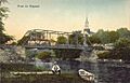
Rigaud Bridge around 1910
See also
 In Spanish: Rigaud (Quebec) para niños
