
Riggisberg facts for kids
Quick facts for kids
Riggisberg
|
||
|---|---|---|

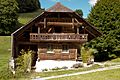
Riggisberg village
|
||
|
||

Riggisberg
Location in Switzerland

Riggisberg
Location in Canton of Bern
|
||
| Country | Switzerland | |
| Canton | Bern | |
| District | Bern-Mittelland | |
| Area | ||
| • Total | 34.5 km2 (13.3 sq mi) | |
| Elevation | 762 m (2,500 ft) | |
| Population
(Dec 2020 )
|
||
| • Total | 2,599 | |
| • Density | 75.33/km2 (195.1/sq mi) | |
| Postal code |
3132
|
|
| Surrounded by | Burgistein, Kirchenthurnen, Lohnstorf, Mühlethurnen, Rüeggisberg, Rümligen | |

Riggisberg is a municipality (a type of town or local government area) in the Bern-Mittelland administrative district. It is located in the canton of Bern in Switzerland.
On January 1, 2009, the nearby municipality of Rüti bei Riggisberg became part of Riggisberg. Later, on January 1, 2021, the former municipality of Rümligen also joined Riggisberg. This means Riggisberg has grown bigger over time!
Contents
A Look at Riggisberg's Past

Riggisberg was first mentioned in old records in 1239 as Ricasperc. Later, in 1270, it was called Riggesberg.
The very first signs of people living here are some Iron Age graves found at Kreuzbühlhölzli. During the time of the Romans, there was a settlement at Muriboden.
In the Middle Ages, a noble family called Riggisberg lived here. But they soon lost their land. By the 13th century, other nobles and monasteries owned parts of the village. The land changed hands many times.
In 1358, Rudolph of Neuchâtel-Nidau gained control over Riggisberg. This included the castle of Uf Gsteig and the village itself. In 1387, the powerful Erlach family from Bern took over. In 1700, the Erlachs built a new, more comfortable castle near the old one.
After the French invasion in 1798, the old noble families lost their power. Riggisberg became part of a new district. In 1869, an Irish cousin, Robert Pigott, inherited the castles. He sold them to the Canton of Bern in 1880. The canton turned the new castle into a building for district administration. The old castle was taken down in 1939.
During World War II, on July 12–13, 1943, Allied planes accidentally bombed Riggisberg. They were trying to attack Italy but dropped about 200 bombs on the village. Riggisberg was badly damaged, but luckily, no one died.
Historically, Riggisberg and Rüti were part of a larger church area called Thurnen. They formed their own church area in 1874 and became fully independent in 1935. The local St. Sebastian Chapel was probably built in the 12th century. The church has been expanded and renovated several times over the centuries.
Riggisberg has always had a mix of farming and small businesses. It grew into an important center for the smaller farming villages around it. In the 20th century, a hospital, a nursing home, and a school for six nearby towns opened here. In 1961, a textile businessman named Werner Abegg started the Abegg-Stiftung (Abegg Foundation). In 1967, the Foundation opened the Textile Museum in Riggisberg.
Rümligen's Story
Rümligen was first mentioned in 1075 as Rumelingen. The oldest sign of people living there is a collection of Bronze Age axes.
In the High Middle Ages, the Freiherr von Rümligen family owned a lot of land. They gave some of their land to help start monasteries like Rüeggisberg and Röthenbach. In 1388, the Freiherren came under the control of Bern. However, they continued to own their estates for a long time. In 1709, Samuel Frisching built the modern Rümligen Castle around the old medieval castle.
Rümligen has always been part of the larger church area of Thurnen. Farmers here grew crops in the valley and raised cattle in seasonal mountain camps. Today, many jobs in Rümligen are still in farming. Most workers travel to nearby cities for their jobs. There is also a small school in the village.
Where is Riggisberg?

Riggisberg covers an area of about 29.83 square kilometers (11.52 square miles). A large part of this land, about 43%, is used for farming. Over half, about 51.1%, is covered by forests. The rest of the area has buildings, roads, rivers, or is unproductive land.
The lowest point in Riggisberg is 669 meters (2,195 feet) above sea level, and the highest point is 1,616 meters (5,302 feet). The village itself is about 763 meters (2,503 feet) high.
The municipality is located in a valley between two hills, the Längenberg and the Gibelegg. It includes the main villages of Riggisberg and Rüti bei Riggisberg, along with smaller hamlets and farmhouses spread out in the area.
Riggisberg's Coat of Arms
The blazon (description) of Riggisberg's municipal coat of arms is: Azure a Royal Crown Or on a Mount of 3 Coupeaux Vert. This means it shows a golden royal crown on three green hills, all on a blue background.
Who Lives in Riggisberg?

_197.jpg)
Riggisberg has a population of about 2,600 people. A small part of the population, about 3.9%, are foreign nationals.
Most people in Riggisberg (about 94.5%) speak German as their main language. Other languages spoken include Albanian and Turkish.
In 2012, about 21.8% of the population were children and teenagers (0–19 years old). Adults (20–64 years old) made up 57.4%, and seniors (over 64 years old) made up 20.7%.
Most homes in Riggisberg are lived in all the time. In 2011, about 43% of the homes were single-family houses.
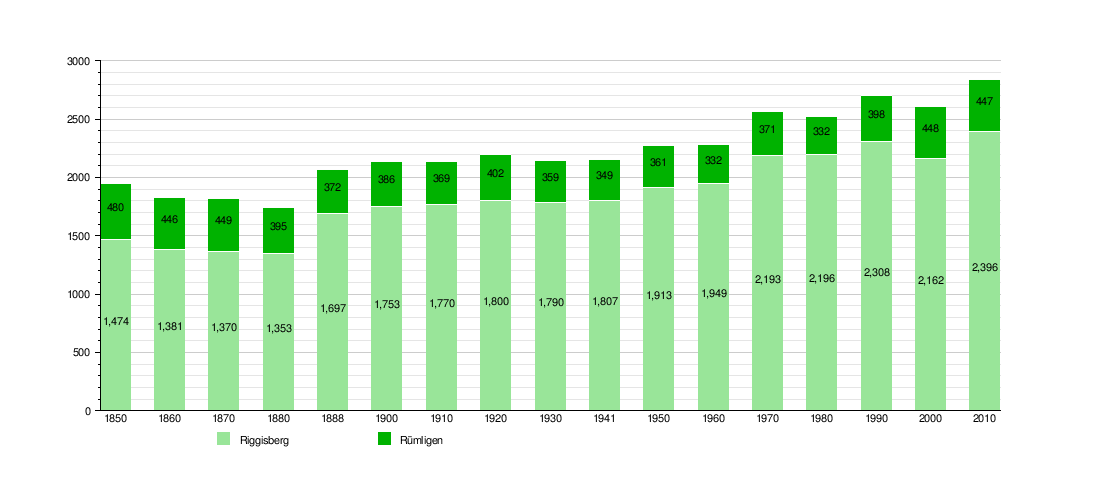
How Riggisberg Has Grown
This chart shows how the population of Riggisberg and Rümligen has changed over time:
Important Buildings and Sites
Several places in Riggisberg are listed as important heritage sites in Switzerland. These include:
- The Abegg-Stiftung(de) (Abegg Foundation building)
- The Speicherstöckli
- Rümligen Castle
These sites are important because they show the history and culture of the area.
-
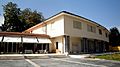
Exterior of the Abegg Foundation building
-
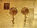
Banner given to mercenaries from Rapperswil by Pope Julius II. Restored in 1993 at the Abegg-Stiftung
-
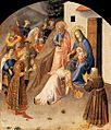
Fra Angelico - Adoration of the Magi from the Abegg collection
-
The Speicherstöckli
-
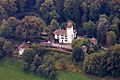
Rümligen Castle


Riggisberg's Economy
In 2011, Riggisberg had a low unemployment rate of 0.73%, meaning most people who wanted to work had jobs. There were about 1,600 people working in the municipality.
Jobs in Riggisberg fall into three main groups:
- Primary sector: This includes jobs related to nature, like agriculture (farming). About 165 people worked in this area.
- Secondary sector: These are jobs that make things, like manufacturing (making goods) or construction (building things). About 247 people worked here.
- Tertiary sector: This is the largest group, including service jobs like sales, transportation, hotels, restaurants, healthcare, and education. About 1,188 people worked in this sector.
Many people who live in Riggisberg also work there. In 2000, about 45.5% of workers lived and worked in the municipality. About 49% of workers used a private car to get to work, while 11.5% used public transportation.
Religion in Riggisberg

Based on the 2000 census, most people in Riggisberg (about 79%) belonged to the Swiss Reformed Church. About 6.4% were Roman Catholic.
There were also smaller groups of people who were Orthodox Christian, Christian Catholic, or other Christians. A small number of people were Jewish, Muslim, or Hindu. About 4.5% of the population did not belong to any church.
Learning and Education
In Riggisberg, about 51.9% of adults have completed upper secondary education (like high school), and 15.6% have gone on to higher education at a university or a specialized college (a Fachhochschule).
The Canton of Bern has a school system that starts with one year of non-required Kindergarten. After that, students go to six years of Primary school. Then, they have three years of lower Secondary school, where students are grouped by their abilities. After secondary school, students can choose to continue their education or start an apprenticeship (learning a trade on the job).
During the 2011-12 school year, there were 359 students in Riggisberg's schools. This included students in kindergarten, primary school, and lower secondary school.
Riggisberg also has a public library called Bibliothek Riggisberg. In 2008, the library had over 8,000 books and other media. It loaned out nearly 20,000 items that year!
See also
 In Spanish: Riggisberg para niños
