Ringgold County, Iowa facts for kids
Quick facts for kids
Ringgold County
|
|
|---|---|

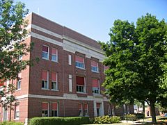
Ringgold County Courthouse in Mount Ayr
|
|

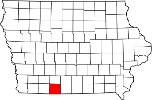
Location within the U.S. state of Iowa
|
|
 Iowa's location within the U.S. |
|
| Country | |
| State | |
| Founded | February 24, 1847 |
| Named for | Samuel Ringgold |
| Seat | Mount Ayr |
| Largest city | Mount Ayr |
| Area | |
| • Total | 539 sq mi (1,400 km2) |
| • Land | 535 sq mi (1,390 km2) |
| • Water | 3.4 sq mi (9 km2) 0.6% |
| Population
(2020)
|
|
| • Total | 4,663 |
| • Density | 8.651/sq mi (3.340/km2) |
| Time zone | UTC−6 (Central) |
| • Summer (DST) | UTC−5 (CDT) |
| Congressional district | 3rd |
Ringgold County is a special area in the state of Iowa, USA. It's called a county. In 2020, about 4,663 people lived here. This makes it one of the smallest counties in Iowa by population.
The main town, or county seat, is Mount Ayr. The county got its name from Major Samuel Ringgold. He was a brave soldier during the Mexican–American War. He was known as a hero from the Battle of Palo Alto in 1846. Ringgold County is also special because its name is unique. No other county in the whole country has the same name!
Contents
Exploring Ringgold County's Location
Ringgold County is located in the southwestern part of Iowa. It has a total area of about 539 square miles. Most of this area is land, around 535 square miles. The rest, about 3.4 square miles, is water. That's about 0.6% of the county's total area.
Main Roads in the County
Getting around Ringgold County is easy with these important roads:
Neighboring Counties Around Ringgold
Ringgold County shares its borders with several other counties:
- To the north: Union County
- To the east: Decatur County
- To the southeast: Harrison County, Missouri (in Missouri)
- To the southwest: Worth County, Missouri (in Missouri)
- To the west: Taylor County
People Living in Ringgold County
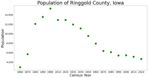
The number of people living in Ringgold County has changed over many years. Here's a look at how the population has grown and shrunk since 1860.
| Historical population | |||
|---|---|---|---|
| Census | Pop. | %± | |
| 1860 | 2,923 | — | |
| 1870 | 5,691 | 94.7% | |
| 1880 | 12,085 | 112.4% | |
| 1890 | 13,556 | 12.2% | |
| 1900 | 15,325 | 13.0% | |
| 1910 | 12,904 | −15.8% | |
| 1920 | 12,919 | 0.1% | |
| 1930 | 11,966 | −7.4% | |
| 1940 | 11,137 | −6.9% | |
| 1950 | 9,528 | −14.4% | |
| 1960 | 7,910 | −17.0% | |
| 1970 | 6,373 | −19.4% | |
| 1980 | 6,112 | −4.1% | |
| 1990 | 5,420 | −11.3% | |
| 2000 | 5,469 | 0.9% | |
| 2010 | 5,131 | −6.2% | |
| 2020 | 4,663 | −9.1% | |
| 2023 (est.) | 4,642 | −9.5% | |
| U.S. Decennial Census 1790-1960 1900-1990 1990-2000 2010-2018 |
|||
Population in 2020
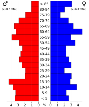
In 2020, the county had 4,663 people. This means there were about 8.6 people for every square mile. Most people (96.68%) said they belonged to one race. About 94.32% were non-Hispanic White.
There were 2,672 homes in the county. Out of these, 1,945 homes were lived in.
Population in 2010
Back in 2010, the population was 5,131 people. This was about 9.5 people per square mile. There were 2,613 homes, and 2,047 of them were lived in.
Towns and Areas in Ringgold County
Ringgold County has several towns and smaller communities.
Cities in Ringgold County
- Beaconsfield
- Benton
- Clearfield (partly in another county)
- Delphos
- Diagonal
- Ellston
- Kellerton
- Maloy
- Mount Ayr
- Redding
- Shannon City (partly in another county)
- Tingley
Special Community: Sun Valley Lake
- Sun Valley Lake is a special type of community. It's called a Census-Designated Place (CDP). This means it's a recognized community but not an official city.
Areas Called Townships
- Athens
- Benton
- Clinton
- Grant
- Jefferson
- Liberty
- Lincoln
- Lotts Creek
- Middle Fork
- Monroe
- Poe
- Rice
- Riley
- Tingley
- Union
- Washington
- Waubonsie
How Many People Live in Each Town?
This table shows the population of cities and towns in Ringgold County, based on the 2020 census.
† This symbol means it's the county seat, the main town.
| Rank | City/Town/etc. | Type of Place | Population (2020 Census) |
|---|---|---|---|
| 1 | † Mount Ayr | City | 1,623 |
| 2 | Diagonal | City | 344 |
| 3 | Kellerton | City | 243 |
| 4 | Sun Valley Lake | CDP | 187 |
| 5 | Tingley | City | 136 |
| 6 | Redding | City | 63 |
| 7 | Benton | City | 39 |
| 8 | Delphos | CDP | 26 |
| 9 | Maloy | City | 22 |
| 10 | Ellston | City | 19 |
| 11 | Beaconsfield | City | 15 |
| 12 | Clearfield (mostly in Taylor County) | City | 6 (278 total) |
| 13 | Shannon City (partially in Union County) | City | 6 (73 total) |
Learning in Ringgold County: Schools
Students in Ringgold County attend schools in several different school districts. These districts help make sure kids get a good education.
- Bedford Community School District
- Creston Community School District
- Diagonal Community School District
- East Union Community School District
- Lamoni Community School District
- Lenox Community School District
- Mount Ayr Community School District
There used to be another school district called Clearfield Community School District. But it closed down on July 1, 2014.
See also
 In Spanish: Condado de Ringgold para niños


