
Roseland, New Jersey facts for kids
Quick facts for kids
Roseland, New Jersey
|
||
|---|---|---|
|
Borough
|
||

The Williams-Harrison House is listed on the U.S. National Register of Historic Places
|
||
|
||

Location of Roseland in Essex County highlighted in red (right). Inset map: Location of Essex County in New Jersey highlighted in orange (left).
|
||

Census Bureau map of Roseland, New Jersey
|
||

Roseland, New Jersey
Location in Essex County, New Jersey

Roseland, New Jersey
Location in New Jersey

Roseland, New Jersey
Location in the United States
|
||
| Country | ||
| State | ||
| County | Essex | |
| Incorporated | April 10, 1908 | |
| Government | ||
| • Type | Borough | |
| • Body | Borough Council | |
| Area | ||
| • Total | 3.64 sq mi (9.43 km2) | |
| • Land | 3.62 sq mi (9.37 km2) | |
| • Water | 0.02 sq mi (0.06 km2) 0.69% | |
| Area rank | 309th of 565 in state 12th of 22 in county |
|
| Elevation | 239 ft (73 m) | |
| Population
(2020)
|
||
| • Total | 6,299 | |
| • Estimate
(2023)
|
6,168 | |
| • Rank | 334th of 565 in state 21st of 22 in county |
|
| • Density | 1,741.0/sq mi (672.2/km2) | |
| • Density rank | 315th of 565 in state 20th of 22 in county |
|
| Demonym(s) | Roselandite | |
| Time zone | UTC−05:00 (Eastern (EST)) | |
| • Summer (DST) | UTC−04:00 (Eastern (EDT)) | |
| ZIP Code |
07068
|
|
| Area code(s) | 973 | |
| FIPS code | 3401364590 | |
| GNIS feature ID | 0885378 | |

Roseland is a small town, called a borough, in western Essex County, New Jersey. In 2020, about 6,299 people lived there. This was an increase of 480 people since the 2010 census.
New Jersey Monthly magazine has often listed Roseland as one of the best places to live in New Jersey. In 2015, it was ranked as the seventh-best place.
Contents
History of Roseland
Roseland was once part of a larger area known as the Horseneck Tract. This tract included several towns like Caldwell and Verona. In 1702, settlers bought this large area, about 14,000 acres (57 km2), from the Lenni Lenape Native Americans. They paid with goods worth about $325. The area was called "Horseneck" because its shape looked like a horse's neck and head.
The community was first named Centerville. But in 1874, its name was changed to Roseland. This was done to avoid confusion with other Centervilles in New Jersey.
One interesting historical spot was the Becker Farm Railroad. This was a miniature train that ran from 1938 to 1972. It was located on the Becker Farm, which used to cover almost half of Roseland. Today, this area is mostly a large business complex. Some parts of the old railroad can still be seen.
In 1907, people in Roseland asked Livingston Township to build a school. When their request was turned down, they decided to form their own town. Roseland officially became a separate borough on April 10, 1908.
Geography and Location
Roseland covers about 3.64 square miles (9.43 km2). Most of this area is land, with a small amount of water. The town is located about 20 miles (32 km) west of New York City. It is part of the larger New York-Northern New Jersey-Long Island metropolitan area.
Roseland shares its borders with several other towns. These include Essex Fells, Livingston, West Caldwell, and West Orange in Essex County. It also borders East Hanover Township in Morris County.
Population and People
| Historical population | |||
|---|---|---|---|
| Census | Pop. | %± | |
| 1910 | 486 | — | |
| 1920 | 609 | 25.3% | |
| 1930 | 1,058 | 73.7% | |
| 1940 | 1,556 | 47.1% | |
| 1950 | 2,019 | 29.8% | |
| 1960 | 2,804 | 38.9% | |
| 1970 | 4,453 | 58.8% | |
| 1980 | 5,330 | 19.7% | |
| 1990 | 4,847 | −9.1% | |
| 2000 | 5,298 | 9.3% | |
| 2010 | 5,819 | 9.8% | |
| 2020 | 6,299 | 8.2% | |
| 2023 (est.) | 6,168 | 6.0% | |
| Population sources: 1910–1920 1910 1910–1930 1940–2000 2000 2010 2020 |
|||
How Many People Live Here?
The 2010 United States census counted 5,819 people living in Roseland. There were 2,345 households, which are groups of people living together. About 28% of these households had children under 18. Most households (60.4%) were married couples.
The population was mostly White (90.74%). There were also people who identified as Black or African American (1.82%), Asian (5.79%), and other races. About 4.50% of the population was Hispanic or Latino.
The average age in Roseland in 2010 was 46.7 years old. About 21% of the people were under 18.
Economy and Businesses
Roseland is home to several important companies. These include Automatic Data Processing (ADP), a large company that helps businesses with payroll. Law firms like Lowenstein Sandler and Connell Foley also have offices here.
Other companies include Curtiss-Wright, which makes engineered products. Polaner makes jams and jellies, and B&G Foods produces pickles and relishes. The pharmaceutical company Organon International opened its main office in Roseland in 2003.
Arts and Culture
The music group Cash Cash has members from Roseland. These include Jean Paul Makhlouf, Alexander Makhlouf, and Samuel Frisch. They signed with Atlantic Records and had a popular song called "Take Me Home".
Education in Roseland
Local Schools
The Roseland School District serves younger students. Children in pre-kindergarten through sixth grade go to Lester C. Noecker Elementary School. In the 2021–22 school year, this school had 467 students.
Regional High School
Students in seventh through twelfth grade attend schools in the West Essex Regional School District. This district serves students from four towns: Essex Fells, Fairfield, North Caldwell, and Roseland.
The schools in this district are:
- West Essex Middle School, for grades 7-8 (with 548 students in 2021-22).
- West Essex High School, for grades 9-12 (with 1,048 students in 2021-22).
Roseland has two seats on the nine-member school board for the high school district.
Transportation
_from_the_overpass_for_Essex_County_Route_609_(Eisenhower_Parkway)_in_Roseland,_Essex_County,_New_Jersey.jpg)
Roads and Highways
As of 2010, Roseland had about 24.95 miles (40.15 km) of roads. The town maintains some roads, while others are kept up by Essex County or the New Jersey Department of Transportation.
Interstate 280 runs through Roseland for about 2.5 miles (4.0 km). This highway connects Roseland to towns like East Hanover Township and Livingston. Other important roads include County Route 527 and County Route 609.
Public Transport
NJ Transit offers bus service from Roseland to Newark on the 71 bus route.
The Whippany Line of the Morristown & Erie Railway is a small train line that carries freight. It runs through Roseland and serves a food products company in the area. This line started in 1895 and connects Morristown to Roseland.
Notable People from Roseland
Many interesting people have lived in or are connected to Roseland:
- Denise Borino-Quinn (1964–2010), an actress known for her role in the TV show The Sopranos.
- Mary Jo Codey (born 1955), a teacher and advocate for mental health. She was once the First Lady of New Jersey.
- Richard Codey (born 1946), a member of the New Jersey Senate.
- Joseph N. DiVincenzo Jr. (born 1952), who has been the County Executive of Essex County since 2003.
- Kevin Monangai (born 1993), a running back who played for the Philadelphia Eagles in the National Football League.
- Kyle Monangai, an American football running back for the Rutgers Scarlet Knights.
- Adella Wotherspoon (1903–2004), a survivor of the 1904 General Slocum disaster. More than 1,000 people died in a fire on that ship.
Images for kids
-
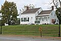
The Williams-Harrison House is listed on the U.S. National Register of Historic Places
-

The official seal of Roseland
-
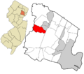
Location of Roseland in Essex County highlighted in red (right). Inset map: Location of Essex County in New Jersey highlighted in orange (left).
-
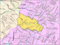
Census Bureau map of Roseland, New Jersey
-
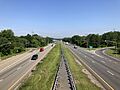
View west along Interstate 280 in Roseland
See also
 In Spanish: Roseland (Nueva Jersey) para niños
