
Rupert's Land facts for kids
Quick facts for kids Rupert's Land |
|||||||
|---|---|---|---|---|---|---|---|
| Territory of British North America | |||||||
| 1670–1870 | |||||||
 Flag of the Hudson's Bay Company
|
|||||||
 Map of Rupert's Land, showing the location of York Factory |
|||||||
| Government | |||||||
| • Type | Trading company | ||||||
| Monarch | |||||||
|
• 1670–1685 (first)
|
Charles II | ||||||
|
• 1837–1870 (last)
|
Victoria | ||||||
| HBC Governor | |||||||
|
• 1670–1682 (first)
|
Prince Rupert of the Rhine | ||||||
|
• 1870 (last)
|
Stafford Northcote | ||||||
| Historical era | Age of Discovery | ||||||
|
• Established
|
1670 | ||||||
|
• Disestablished
|
15 July 1870 | ||||||
|
|||||||
| Today part of | Canada ∟ Alberta ∟ Manitoba ∟ Nunavut ∟ Ontario ∟ Quebec ∟ Saskatchewan United States ∟ Minnesota ∟ North Dakota ∟ South Dakota ∟ Montana |
||||||
Rupert's Land was a huge area of land in North America. Most of this land is now part of Canada, but some parts are in the United States. A powerful trading company called the Hudson's Bay Company used to own it.
The land was named after Prince Rupert of the Rhine. He was the first leader of the Hudson's Bay Company. In 1670, Charles II of England gave the company special rights to this land. This meant they had a monopoly, or exclusive control, over all fur trading along the rivers in the territory.
Contents
How Rupert's Land Was Formed
Rupert's Land was created in 1670 when the King of England gave the Hudson's Bay Company control over a vast area. This area included all the lands whose rivers drained into Hudson Bay. This was a very large part of what is now Canada.
The company's main business was trading furs, especially beaver pelts. These furs were very popular in Europe for making hats and clothing. The company built trading posts across the territory.
The Hudson's Bay Company's Power
The Hudson's Bay Company was not just a business. It also acted like a government in Rupert's Land. It made laws, kept order, and had its own courts. The company's leader was called the Governor.
For many years, the company controlled all trade in this huge region. They traded with many First Nations peoples. These groups were very important to the fur trade.
Changes to Rupert's Land
Over time, other companies also wanted to trade furs. In 1821, the Hudson's Bay Company joined with another big fur trading company. This was the North West Company from Montreal. This merger made the Hudson's Bay Company even stronger. It also added the North-Western Territory to their control.
Selling the Land
By the late 1800s, the importance of the fur trade was changing. Also, the new country of Canada was growing. In 1869, the Hudson's Bay Company sold its rights to Rupert's Land and the North-Western Territory to the Canadian Dominion. The Canadian Dominion was the early version of modern-day Canada.
This sale was a very important event in Canadian history. It allowed Canada to expand its borders greatly.
How Rupert's Land Was Divided
In 1870, the Manitoba Act was passed. This law created the Canadian province of Manitoba. This was the first new province formed from Rupert's Land.
The rest of Rupert's Land was then divided up. Parts of it became new areas within the provinces of Saskatchewan, Alberta, Ontario, and Quebec.
Some parts of Rupert's Land also became part of the United States. In 1818, the border between Canada and the US was set along the 49th latitude line. This meant that parts of Rupert's Land south of this line became US states. Today, these include Minnesota, North Dakota, Montana, and South Dakota.
Rupert's Land Today
Even though Rupert's Land no longer exists as a territory, its name is still used. It is the name of an ecclesiastical province (a church region) of the Anglican Church of Canada. It is also the name of an Anglican diocese (a church district) in Manitoba.
Images for kids
-
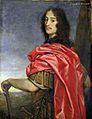
Prince Rupert of the Rhine, namesake of the land
-
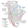
The Hudson Bay drainage basin connects primarily to the Labrador Sea just south of Davis Strait as depicted on most atlases such as those of the National Geographic Society just north of the 60th parallel north and northeast of the Labrador Peninsula
-
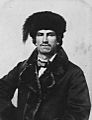
Métis fur trader ca. 1870
-
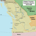
Map of the Columbia District, also referred to as Oregon Country


See also
 In Spanish: Tierra de Rupert para niños
