
Saint-Maurice, Switzerland facts for kids
Quick facts for kids
Saint-Maurice
|
||
|---|---|---|
_-_juillet_2022.jpg)
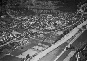
View of Saint-Maurice with the Dent du Salantin (left) and the Dents du Midi in the background
|
||
|
||

Saint-Maurice
Location in Switzerland

Saint-Maurice
Location in Canton of Valais
|
||
| Country | Switzerland | |
| Canton | Valais | |
| District | Saint-Maurice | |
| Area | ||
| • Total | 14.92 km2 (5.76 sq mi) | |
| Elevation | 414 m (1,358 ft) | |
| Population
(Dec 2020 )
|
||
| • Total | 4,518 | |
| • Density | 302.82/km2 (784.3/sq mi) | |
| Postal code |
1890
|
|
| Surrounded by | Bex (VD), Collonges, Evionnaz, Lavey-Morcles (VD), Massongex, Mex, Vérossaz | |

Saint-Maurice is a historic city in the Swiss canton of Valais. It is the main town of the district of Saint-Maurice. On January 1, 2013, the nearby village of Mex joined Saint-Maurice.
This city is built where an Ancient Roman outpost called Agaunum once stood. It is also home to the famous 6th-century Abbey of Saint-Maurice d'Agaune. Saint-Maurice is located at the start of a mountain pass that leads to the upper Rhône valley. Because of its important location, defense structures were built here from the 15th century onwards. The Fortress Saint-Maurice was constructed in the mountains around the city between 1880 and 1995.
Contents
History of Saint-Maurice


Saint-Maurice was first mentioned around the year 200 as Acaun[ensis]. Its name was changed from Acaunum (also known as Agaune) to Saint-Maurice in 1003. This change honored Saint Maurice, a very important figure for the town.
Archaeologists have found signs of a Bronze Age settlement at the base of a rocky hill in the town. Not much is known about the exact layout of the Roman era town here. There was a customs post in Acaunum where taxes were collected on goods. People also believed there was a shrine to water spirits.
According to stories, Saint Maurice and his companions from the Theban Legion were killed here between 286 and 310 AD. Around 360-370, Theodul, the first Bishop of Valais, built a church in Acaunum to honor them. This church became a popular place for pilgrimage. In 515, King Sigismund of Burgundy founded the Abbey, giving it a lot of land.
Changes in Control
In 523, the Franks invaded the town. Later, in 574, the Lombards took control. In the mid-10th century, the Saracens also invaded. In 888, Rudolf of the Welf family was crowned King of Burgundy at the Abbey. In 1034, the Duchy of Savoy gained control of the entire Chablais region, which included Saint-Maurice.
Saint-Maurice and the town of Monthey formed a district. Around 1300, the local leader moved from Monthey to Saint-Maurice. The abbot of the Abbey ruled over both the Abbey and the town. Town citizens were first mentioned in 1170. By 1275, the citizens could elect two mayors.
In 1246, Amadeus IV, Count of Savoy gave Saint-Maurice to King Henry III of England. This was in exchange for money, along with other castles.
Town Walls and Swiss Control
In the 13th century, the town was surrounded by walls for protection. Count Amadeus V of Savoy confirmed the city's rules in 1317. At that time, the town had about 1,400 to 1,800 people. In 1475, the Lower Valais region, including Saint-Maurice, became a partner of the Swiss Confederation. From 1475 until 1798, Saint-Maurice was the capital of its province.
In 1476, Bern started building a castle in the narrow Rhone valley at Saint-Maurice. It was finished in 1646. However, a big fire in 1693 destroyed the castle's storage building and much of its gunpowder.
Modern Era Developments
During the Helvetic Republic, Saint-Maurice was a district capital. After the Republic ended, it was a capital of a larger area from 1802 to 1804. From 1810 to 1814, it was part of the French department. In 1822, the villages of Vérossaz and Evionnaz became separate from the municipality.

The Abbey was the most important religious place. Other religious groups also came to Saint-Maurice. These included the Capuchins in 1611 and various Sisters' orders later. The Capuchin monastery's chapel was built in 1640. The church of Saint-Sigismond has been the main church since the mid-12th century. The current church building dates from 1715.
The Hospice of Saint-Jacques, which still stands, was built in the 10th century. The church of Notre-Dame-du-Scex was built in the 18th century on older ruins. The Abbey College, a school, was first mentioned in the Middle Ages. In 1806, the canton took over supporting the school, and it became the Collège de Saint-Maurice.

The narrow canyon at Saint-Maurice helped both trade and defense. A bridge over the Rhone was built around the 12th century. This was the first bridge upstream of Lake Geneva after the Roman bridge of Massongex. The defenses in the canyon were expanded over time. During World War II, the Saint-Maurice fortifications were a key part of Switzerland's defense plan. In 1995, the fortifications were opened as a tourist attraction.
A large rail yard was built in 1860 after a railway was constructed. This is now part of the Simplon Railway. From 1898 to 1940, the Bois Noir power plant supplied electricity to Lausanne. The first major factory in Saint-Maurice was a cement factory, which operated from the 1950s to 1986. A printing house opened in 1934. Several newspapers have also been published in Saint-Maurice over the years.
The Abbey and the Feengrotte (Fairy Cave), which opened in 1863, attract many visitors. The Saint-Amé clinic, founded in 1901, was rebuilt in 1996 as a center for elderly care. The city also has a branch of the Mediathek Wallis, a regional library. The Educators' School of Wallis is located here too.
Geography of Saint-Maurice

Saint-Maurice covers an area of about 7 square kilometers (2.7 square miles). About 21.5% of this land is used for farming. Forests cover 42% of the area. Buildings and roads make up 32.5% of the land. Rivers and lakes cover 2.8%, and 1.4% is unproductive land, like rocky areas.
The city of Saint-Maurice is located at the foot of a rock wall. It sits at a narrow point in the Rhône valley, on the left side of the Rhône river. The city is on important routes that cross the Valais alpine passes into Italy. It includes the main town of Saint-Maurice and the small villages (called hamlets) of Épinassey and Les Cases. Until 1822, the villages of Evionnaz and Vérossaz were also part of Saint-Maurice.
The villages of Mex and Saint-Maurice joined together on January 1, 2013.
City Symbol
The blazon (description) of the city's coat of arms is: "Blue and red, with a silver cross that has three knobs at each end."
People of Saint-Maurice
Saint-Maurice has a population of about 4,400 people. About 26% of the people living here are foreign nationals. Over the last ten years (2000–2010), the population grew by about 14.5%. Most of this growth was due to people moving into the city.
Most people (about 86.1%) in Saint-Maurice speak French as their first language. Italian is the second most common language (3.4%), followed by Albanian (3.1%).
In 2008, about 48.7% of the population was male and 51.3% was female. About 31.9% of the people living in Saint-Maurice in 2000 were born there. Another 25.6% were born in the same canton, Valais.
Children and teenagers (0–19 years old) make up about 24.4% of the population. Adults (20–64 years old) make up 57.8%, and seniors (over 64 years old) make up 17.8%.
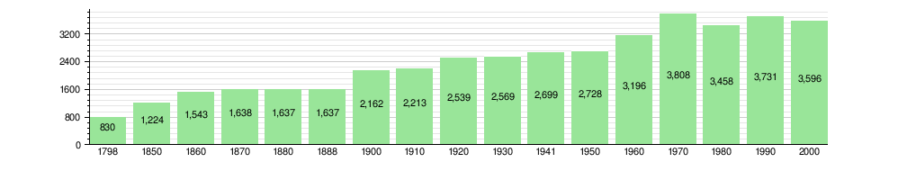
The chart below shows how the population of Saint-Maurice has changed over time:
Important Heritage Sites
Several places in Saint-Maurice are listed as important Swiss heritage sites. These include the Abbey of St. Maurice, Agaunum, Saint-Maurice Castle with its Cantonal Military Museum, the Maison de la Pierre, and the Bridge over the Rhône river (which is shared with Bex, Vaud). The entire Saint-Maurice castle and city area are part of the Inventory of Swiss Heritage Sites.
-
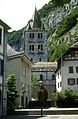
St-Maurice D’Agaune Abbey
-
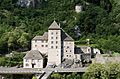
Saint-Maurice Castle
-
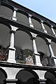
Columns inside the Maison de la Pierre
-
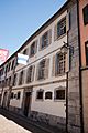
Front view of the Maison de la Pierre
-
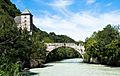
Bridge over the Rhône river


Economy and Jobs
In 2010, Saint-Maurice had an unemployment rate of 6.5%. In 2008, there were 16 people working in farming. There were 257 people working in manufacturing and construction. The largest number of jobs, 1,522, were in the service sector (like shops, hotels, and education).
Many people who live in Saint-Maurice work in other towns. Also, many people from other towns come to work in Saint-Maurice. In 2000, about 10.3% of workers used public transportation to get to work, and 59.9% used a private car.
Religion in Saint-Maurice

According to the 2000 census, most people in Saint-Maurice (75.6%) were Roman Catholic. About 7.9% belonged to the Swiss Reformed Church. There were also smaller numbers of people who were Orthodox Christians, Christian Catholics, or belonged to other Christian churches. About 6.95% of the population was Islamic. A small number of people were Buddhist or belonged to other religions. About 3.48% of the population did not belong to any church.
Education in Saint-Maurice
About 31.3% of the people in Saint-Maurice have finished non-mandatory upper secondary education. About 8.3% have completed higher education, such as a university degree.
In 2000, 1,273 students came to Saint-Maurice to attend school. At the same time, 115 residents went to schools outside the municipality.
Saint-Maurice is home to the Médiathèque Valais - Saint-Maurice library. In 2008, the library had over 70,000 books and other media. It loaned out over 81,000 items that year.
Transportation
The city has a railway station, St-Maurice. This station is on the Saint-Gingolph–Saint-Maurice and Simplon lines. Trains regularly connect Saint-Maurice to Annemasse, Lausanne, Geneva Airport, and Brig.
Notable People from Saint-Maurice
- Jean-François Fournier (born 1966 in Saint-Maurice) is a writer, playwright, poet, and biographer.
See also
 In Spanish: San Mauricio (Valais) para niños
