Oceanport, New Jersey facts for kids
Quick facts for kids
Oceanport, New Jersey
|
||
|---|---|---|
|
Borough
|
||

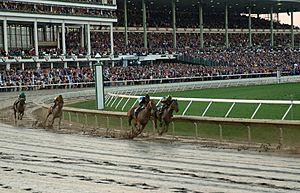
Thoroughbred horse racing at Monmouth Park Racetrack in Oceanport
|
||
|
||

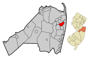
Map of Oceanport in Monmouth County. Inset: Location of Monmouth County highlighted in the State of New Jersey.
|
||

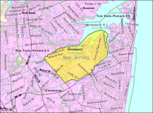
Census Bureau map of Oceanport, New Jersey
|
||
| Country | ||
| State | ||
| County | Monmouth | |
| Incorporated | May 11, 1920 | |
| Government | ||
| • Type | Borough | |
| • Body | Borough Council | |
| Area | ||
| • Total | 3.79 sq mi (9.83 km2) | |
| • Land | 3.17 sq mi (8.22 km2) | |
| • Water | 0.62 sq mi (1.61 km2) 16.39% | |
| Area rank | 305th of 565 in state 21st of 53 in county |
|
| Elevation | 20 ft (6 m) | |
| Population
(2020)
|
||
| • Total | 6,150 | |
| • Estimate
(2023)
|
6,166 | |
| • Rank | 342nd of 565 in state 27th of 53 in county |
|
| • Density | 1,938.8/sq mi (748.6/km2) | |
| • Density rank | 297th of 565 in state 36th of 53 in county |
|
| Time zone | UTC−05:00 (Eastern (EST)) | |
| • Summer (DST) | UTC−04:00 (Eastern (EDT)) | |
| ZIP Code |
07757
|
|
| Area code(s) | area codes 732 and 848 | |
| FIPS code | 3402554570 | |
| GNIS feature ID | 0885334 | |
| Website | ||
Oceanport is a small town, called a borough, located in Monmouth County, New Jersey. It's part of the Jersey Shore region in Central Jersey. In 2020, about 6,150 people lived there. This was a small increase from 2010.
Oceanport became a borough on May 11, 1920. It was created from parts of Eatontown Township. New Jersey Monthly magazine once ranked Oceanport as the 4th best place to live in New Jersey in 2008.
Contents
Exploring Oceanport's Geography
Oceanport covers about 3.80 square miles (9.83 km²). Most of this area is land, about 3.17 square miles (8.22 km²). The rest is water, which is about 0.62 square miles (1.61 km²). This means about 16% of Oceanport is water.
Oceanport shares its borders with several other towns in Monmouth County. These include Little Silver, Shrewsbury, Long Branch, Eatontown, and West Long Branch. It also has water borders with Monmouth Beach and Rumson. Oceanport is like a small finger of land that sticks out into the Shrewsbury River.
Some smaller areas and neighborhoods within Oceanport include Elkwood Park, Fort Monmouth, Gooseneck Point, Port-au-peck, and Sands Point.
Understanding Oceanport's Population
| Historical population | |||
|---|---|---|---|
| Census | Pop. | %± | |
| 1930 | 1,872 | — | |
| 1940 | 3,159 | 68.8% | |
| 1950 | 7,588 | 140.2% | |
| 1960 | 4,937 | −34.9% | |
| 1970 | 7,503 | 52.0% | |
| 1980 | 5,888 | −21.5% | |
| 1990 | 6,146 | 4.4% | |
| 2000 | 5,807 | −5.5% | |
| 2010 | 5,832 | 0.4% | |
| 2020 | 6,150 | 5.5% | |
| 2023 (est.) | 6,166 | 5.7% | |
| Population sources:1930 1940–2000 2000 2010 2020 |
|||
Population Details from 2010
In 2010, there were 5,832 people living in Oceanport. There were 2,227 households, which are groups of people living together. The town had about 1,834 people per square mile.
Most people in Oceanport were White (93.36%). Other groups included Black or African American (3.00%) and Asian (1.59%). About 4.05% of the population was Hispanic or Latino.
About 31.8% of households had children under 18. Many families (59.7%) were married couples. The average household had 2.59 people. The average family had 3.12 people.
The median age in Oceanport was 44.4 years old. This means half the people were younger and half were older. About 23.4% of the population was under 18. About 16.1% were 65 or older.
In 2010, the typical household earned about $89,208 per year. The typical family earned about $108,958 per year. The average income per person was about $52,252. A small number of families (3.1%) and people (4.2%) lived below the poverty line.
Sports and Fun in Oceanport
Monmouth Park is a famous place in Oceanport. It's a thoroughbred horse race track. The track hosts the annual Haskell Invitational Handicap, a very important horse race. It's one of the biggest horse racing events after the Triple Crown.
The track was built in Oceanport in 1946. Its location near the shore made it easy for people from New York and North Jersey to visit. In October 2007, Monmouth Park hosted the Breeders' Cup, a huge horse racing event. Nearly 70,000 fans came to watch.
In June 2018, Monmouth Park became the first place in New Jersey to offer sports betting. This happened after the United States Supreme Court made it legal.
Connecting with Oceanport: Telephone Service
For landline phones, Oceanport uses area codes 732 and 848. Specific phone numbers start with 222, 389, 229, 544, and 542 in Area Code 732. Mobile phones also use area codes 732/848, and sometimes area code 908.
Learning in Oceanport: Education
Students in Oceanport go to public schools managed by the Oceanport School District. This district also includes students from Sea Bright.
The district has two schools:
- Wolf Hill Elementary School: For students in pre-Kindergarten through 4th grade.
- Maple Place Middle School: For students in grades 5–8.
After eighth grade, students attend Shore Regional High School. This high school is for students from Oceanport, Monmouth Beach, Sea Bright, and West Long Branch. It is located in West Long Branch. Oceanport has three seats on the high school's board of education.
Getting Around Oceanport: Transportation
As of 2010, Oceanport had about 31.26 miles of roads. Most of these roads (25.47 miles) are maintained by the borough itself. The county maintains 5.46 miles, and the state maintains 0.33 miles.
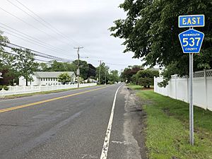
Route 71 is a state road that goes near Oceanport. CR 537 passes right through the town.
Public Transportation Options
NJ Transit offers train service at the Monmouth Park station. This service is mainly for the Monmouth Park Racetrack and runs from May to October. You can take the North Jersey Coast Line train south to towns like Belmar and Bay Head. Or, you can go north to places like Long Branch, Newark, and even Penn Station in Midtown Manhattan.
NJ Transit also has a local bus service on the 831 route.
Famous People from Oceanport
Many interesting people have lived in or are connected to Oceanport:
- Charles W. Billings (1866–1928): Oceanport's first mayor and an Olympic gold medalist in shooting.
- Phil Bredesen (born 1943): A former Governor of Tennessee.
- George Conway (circa 1878–1939): A horse trainer who trained War Admiral, a famous Triple Crown winner.
- John D'Amico Jr. (born 1941): A former Oceanport council member and state senator.
- Brad Faxon (born 1961): A professional golfer.
- Harry Flaherty (born 1989): A professional football player.
- S. Thomas Gagliano (1931–2019): A politician who served on the Oceanport borough council and in the New Jersey Senate.
- Lewis G. Hansen (1891–1965): A member of the New Jersey General Assembly.
- Charles J. O'Byrne (born 1959): A top aide to a former Governor of New York.
- Reverdy C. Ransom (1861–1959): A civil rights activist and leader in the African Methodist Episcopal Church.
- Charles Rembar (1915–2000): A lawyer known for his work on First Amendment cases.
- Kevin Smith (born 1970): A famous filmmaker who lived in Oceanport.
See also
 In Spanish: Oceanport para niños


