
Scheduled monuments in Mendip facts for kids

Mendip is a local government area in Somerset, England. It's mostly countryside, covering about 738 square kilometers (285 square miles). Around 110,000 people live there. The main office is in Shepton Mallet, but the biggest town is Frome, which has more than twice as many people.
A scheduled monument is a very important historical or archaeological site in the country. It gets special legal protection. Historic England helps decide which places are important enough to be on this list. These sites are protected by a law called the Ancient Monuments and Archaeological Areas Act of 1979. A "monument" can be many things, not just something you see above ground. It could be a prehistoric standing stone, a burial site, Roman ruins, medieval castles or monasteries, or even more recent industrial sites and buildings from the World Wars.
There are 234 scheduled monuments in Mendip. These include many ancient burial mounds called bowl barrows and round barrows. There are also other tumuli (burial mounds) from the Neolithic (New Stone Age), Bronze Age, and Iron Age. Famous examples are the Priddy Circles and the Priddy Nine Barrows and Ashen Hill Barrow Cemeteries. You can also find Iron Age hill forts on top of hills and lake villages in the lowlands. These lake villages, like Meare and Glastonbury Lake Village, were often connected by wooden paths called timber trackways, such as the Sweet Track.
Mendip also has several Roman sites, especially near the Charterhouse Roman Town, where they mined lead. Some old coal mining sites are on the list too. Two very important religious places in Mendip are Glastonbury Abbey and Wells Cathedral. Parts of these sites, including old barns for collecting taxes (called tithe barns) and The Abbot's Fish House, are also protected.
Ancient defensive walls like Ponter's Ball Dyke were later joined by medieval castles. These include motte-and-bailey castles (castles with a mound and a courtyard) like Farleigh Hungerford, Nunney, and Fenny Castle. Places important for business and industry are also listed, such as the Old Iron Works at Mells and various market crosses. The newest site on the list is a World War II bombing decoy complex on Black Down. This was built in 1940 to trick enemy planes.
Template:TOC limit=3
Contents
Ancient Burial Mounds and Circles
This section explores the ancient burial sites and mysterious circles found across Mendip, offering a glimpse into the lives of people from thousands of years ago.
Bowl Barrows and Round Barrows
Many of Mendip's scheduled monuments are bowl barrows and round barrows. These are types of ancient burial mounds. They were built by people in the Neolithic and Bronze Age periods. These mounds are often found in groups, forming cemeteries.
- Ashen Hill barrow cemetery: This is a group of eight round barrows near Priddy. They date back to the Bronze Age. These barrows are on hilltops and are thought to be connected to the Priddy Circles. When people dug here in 1815, they found cremation burials and special items buried with the dead.
- Barrow, 350 meters east of Harptree Lodge: A bowl barrow near Priddy Circles. It's about 20 meters wide.
- Bell barrow south of Blackwell Tyning Plantation: A bell barrow about 32 meters wide in Emborough.
- Bowl barrow 100 meters north east of Home Farm Cottage: This bowl barrow near Ston Easton is 21 meters wide.
- Bowl barrow 300 meters north east of Whitnell Corner: A 10-meter wide bowl barrow in Emborough.
- Bowl barrow 450 meters east of Bristol Plain Farm: This bowl barrow near Priddy is 21 meters wide.
- Bowl barrow, 455 meters west of Brimble Pit Pool: A bowl barrow near Westbury that is 11 meters wide.
- Bowl barrow 510 meters south east of Lodmore Farm: A bowl barrow near Priddy that is 19 meters wide.
- Bowl barrow 550 meters south of Bristol Plain Farm: Part of a line of round barrows near Rodney Stoke. It's 12 meters wide.
- Bowl barrow 610 meters northwest of Whitestown Farm: A large bowl barrow near Priddy, about 30 meters wide.
- Bowl barrow on Stock Hill: Part of a round barrow cemetery near Chewton Mendip. It's 12.5 meters wide.
- Pair of bowl barrows 350 meters NNE of Whitnell Corner: Two bowl barrows near Emborough, one 30 meters wide and the other 18 meters.
- Pair of bowl barrows 405 meters east of East Water Drove: Two bowl barrows near Chewton Mendip that are part of the Priddy Nine Barrows Cemetery. They are about 20 meters wide.
- Round barrow on Beacon Hill: Three round barrows near Ashwick.
- Round barrows in and near Wright's Piece: A group of round barrows near Priddy.
- Small Down Knoll camp: This is a Bronze Age hill fort near Evercreech. It has multiple walls and ditches. Inside, there are about 14 round barrows, which are burial mounds. People have found Iron Age pottery here too.
Long Barrows
Long barrows are another type of ancient burial mound, typically longer than they are wide.
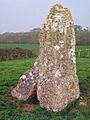
- The Devil's Bed and Bolster long barrow: This long barrow near Beckington is 35 meters long and 21 meters wide.
Priddy Circles
- Priddy Circle and barrow cemetery 400 meters north of Castle of Comfort Inn: These are four large circular earthworks near Priddy. They are thought to be ancient ritual sites from the Neolithic period, similar to a henge.
- Three of the Priddy Circles and one barrow, 400 meters west of Castle Farm: This site includes three of the famous Priddy Circles and a nearby burial mound.
Ancient Settlements and Forts
Mendip is home to many remains of ancient settlements and defensive structures, showing how people lived and protected themselves in the past.
Hill Forts
Hill forts are ancient settlements built on hillsides or hilltops for defense.
- Camp 600 yards (548 meters) E of Charterhouse: An Iron Age hill fort near Priddy. It's linked to the Charterhouse Roman Town.
- Hales Castle: a ringwork and associated earthworks on Coles Hill: This medieval castle near Frome was built after the Norman Conquest. It has a circular earthwork and an unfinished courtyard.
- Hillfort at Fox Covert, 550 meters north east of Lamyatt Lodge: An early Iron Age earthwork near Lamyatt. It was probably used to keep livestock.
- Hillfort on Roddenbury Hill: An Iron Age hill fort near Selwood. It has a single protective wall up to 1.6 meters high.
- Kingsdown camp, Mells Down: An Iron Age hill fort near Buckland Dinham. It's a small, square-shaped fort.
- King's Castle enclosures, Iron Age defended settlement: An Iron Age hilltop settlement near St Cuthbert Out. It has an unusual layout with linked enclosures.
- Maesbury Castle small multivallate hillfort: An Iron Age hill fort near Croscombe. It has a single rampart up to 6 meters high.
- Small multivallate promontory fort on Blacker's Hill: An Iron Age hill fort near Chilcompton. It was defended by steep drops and two ramparts.
- Tedbury Camp: An Iron Age hill fort near Great Elm. It has two parallel defensive banks. Roman coins have also been found here.
- Wadbury Camp: An Iron Age hill fort near Mells. It covers 30 hectares and is surrounded by a bank.
- Westbury Camp, slight univallate hillfort, 750 meters north of Stokewood Cottage: An Iron Age hill fort near Rodney Stoke. Its defenses are built into the hillside.
Lake Villages
These unique settlements were built on artificial islands in marshy areas.
- Glastonbury Lake Village: An Iron Age village near Godney. It's considered the best-preserved prehistoric village found in the UK. It was built on a man-made island of timber and clay around 250 B.C.
- Lake villages NW of Oxenpill: The site of an Iron Age settlement near Meare. There were two villages built on artificial foundations in the now-drained Meare Pool.
Timber Trackways
Ancient wooden paths built across wet lands.
- Section of the Abbot's Way trackway, 500 meters WSW of Honeygar Farm: The preserved remains of a wooden trackway built between 2630 and 2280 B.C. near Meare.
- Sections of the Sweet Track and Post Track, 240 meters south west of Sunnyside Farm: A section of the Sweet Track near Meare, an ancient path built around 3807 or 3806 B.C. It was made of crossed wooden poles and oak planks.
- Sections of the Sweet Track and Post Track, 250 meters ESE of Station House: Another section of the Sweet Track and the older Post Track near Meare.
- Timber trackway site, 700 meters west of Honeygar Farm: Remains of a brushwood track built between 3650 and 3500 B.C. near Meare.
- Tinney's trackways, west of Sharpham Bridge: The route of several brushwood tracks near Sharpham.
Roman Remains
The Romans left their mark on Mendip, especially through mining and settlements.
- An area of the Romano-British linear village at Fosse Lane, Shepton Mallet: Earthworks from a Roman-British village near the Fosse Way in Shepton Mallet.
- Charterhouse lead works: These lead and silver mines near Priddy were used by the Romans from at least A.D. 49.
- Roman amphitheatre 1/2 mile (800 meters) N of Charterhouse: An amphitheater near Charterhouse, unique for being at a lead mine. It was likely used for entertainment for Roman soldiers.
- Roman building 270 meters north east of Priddy church: The site of a Roman building near Priddy, with artifacts from the 1st to 3rd centuries.
- Roman building 600 yards (549 meters) SW of Lower Sutton Farm: Earthworks from a Roman settlement near Ditcheat. Pottery from the 3rd and 4th centuries has been found.
- Roman building at Lamyatt Beacon, Creech Hill: The site of a Roman-Celtic temple near Lamyatt, used from 250 A.D. to 375 A.D.
- Roman settlement at Town Field: This Roman town near Priddy grew around lead and silver mines.
- Romano-British settlement on Stoke Moor: Earthworks from a large Roman settlement near Rodney Stoke. Coins and pottery from the 1st to 3rd centuries have been found.
- Roman villa complex, 330 meters south-west of St Algar's Farm: Earthworks from a Roman villa near Selwood, where many artifacts have been found.
- Roman villa NW of Port Way: Earthworks from a Roman villa near Hemington.
- Roman villa NW of Two Acre Plantation: Earthworks from a Roman villa near Street.
- Whatley Combe Roman villa: Earthworks from a multi-room Roman villa with a bath suite near Nunney, used in the 4th century.
Medieval and Later Structures
This section covers important buildings and sites from the Middle Ages and more recent times.
Castles and Fortified Sites
- Farleigh Hungerford Castle: A castle near Farleigh Hungerford built in the 14th century. It was extended to include the local church. It was damaged during the English Civil War and is now a ruin managed by English Heritage.
- Fenny Castle: a motte and bailey castle: The remains of a motte and bailey castle near Wookey, built on a natural hill.
- Nunney Castle: A moated castle near Nunney built in the late 14th century. It was damaged during the English Civil War and is now a ruin. It's considered one of the most impressive castles in Somerset.
- Marston Moat: The site of a fortified manor house near Trudoxhill built before 1195, surrounded by a wide moat.
Religious Sites
- Beckery Chapel and cemetery (site of): The site of a chapel and medieval cemetery near Glastonbury. Excavations in 1967 found the remains of 63 burials.
- Bishop's palace: Earthworks from a medieval Bishop's Palace near Wookey, first mentioned in 1224.
- Bishop's Palace ruined portions, walls and well house: The Bishop's Palace in Wells has been home to bishops for 800 years. It includes a chapel, great hall, walls, gatehouse, and moat.
- Glastonbury Abbey: A famous monastery in Glastonbury founded in the 7th century. It was once very rich and powerful but was destroyed in 1184 and later rebuilt. It was closed down in 1539 by King Henry VIII. Legends link it to King Arthur and Joseph of Arimathea.
- St Michael's Church, monastic remains, and other settlement remains on Glastonbury Tor: The tower of St Michael's Church on Glastonbury Tor is a famous landmark. It was built in the 14th century after an earlier wooden church was destroyed by an earthquake.
- Witham Priory: Earthworks from a Carthusian monastery near Witham Friary that was active from the 12th to 16th centuries.
Industrial and Commercial Sites
- Fussell's Lower Works: an iron edge tool works, 210 meters south east of Wadbury: A ruined iron works near Mells that made tools. It's also an important breeding site for bats.
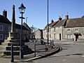
- Market cross in the market place: A hexagonal market cross in Shepton Mallet built in the early 16th century.
- Medieval and post-medieval coal mining remains in Harridge Wood and Edford Wood South: Earthworks from coal mining near Ashwick that continued until the 17th or 18th centuries.
- Medieval coal mining remains immediately south of Benter Cross: Earthworks from medieval coal mining near Ashwick, possibly starting as early as the Roman period.
- Vobster Breach colliery, 890 meters ENE of Tweed Farm: The remains of a 19th-century coal mine near Leigh-on-Mendip, including coking ovens and railway lines.
Other Notable Structures
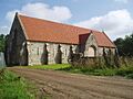
- Bishop's tithe barn: A 15th-century barn in Wells used to store crops.
- Bolter's Bridge, Hornblotton: A medieval stone bridge over the River Alham near Ditcheat.
- Browne's Gate: An entrance gateway into the walled area around Wells Cathedral, built around 1451.
- Fenny Castle Cross: a medieval wayside cross 20 meters north west of Castle Farm, Castle: The remains of a 14th-century roadside cross near Wookey.
- Dovecote 220 meters north of St Philip and St James's Church: A 15th-century stone dovecote (a building for pigeons) near Norton St Philip.
- Drying house at The Coach House, Willow Vale: A circular stone building in Frome used for drying cloth in the 18th or 19th century.
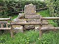
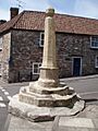
- Medieval standing cross 50 meters west of St Peter's Church: A 15th-century market cross in Evercreech.
- Medieval standing cross 80 meters south of St Mary's Church: A 14th-century cross near Croscombe.
- Medieval wayside cross at Bodden: The remains of a medieval cross near Doulting.
- Murtry Old Bridge: A medieval stone arch bridge near Buckland Dinham.
- Rode Bridge: A stone bridge with two arches over the River Frome near Rode, built around 1777.
- Section of medieval road, south of Pomparles Bridge, north of Street: The site of an old medieval road near Street.
- The Abbey Barn at Abbey Farm: A 14th-century barn in Glastonbury that belonged to Glastonbury Abbey. It's now the Somerset Rural Life Museum.
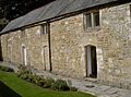
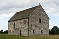
- The Abbot's Fish House and fishponds: A 14th-century building near Meare used by monks from Glastonbury Abbey for storing and processing fish. It's the only one of its kind left in England.
- The Falconry, Farleigh Hungerford: A stone building near Norton St Philip from the 14th or 15th century, used as a cartshed and for falconry.
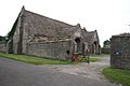
- The tithe barn: A 15th-century tithe barn near Doulting that belonged to Glastonbury Abbey.
- Tithe Barn, Pilton: A 14th-century tithe barn near Pilton that also belonged to Glastonbury Abbey. It was restored with help from the Glastonbury festival organizer.
- The Tribunal: A 15th-century merchant's house in Glastonbury. It's now a tourist information center and a museum with artifacts from Glastonbury Lake Village.
- Westbury village cross: A 15th-century cross in Westbury.
Other Archaeological Sites
This section includes various other historical sites, from ancient caves to deserted villages.
Caves
- Badger Hole, Wookey: A dry cave near St Cuthbert Out with Ice Age sediments. Foundations of a 1st-century hut were found outside.
- Bracelet Cave: A cave near St Cuthbert Out where nine human skeletons, likely from the Bronze Age, and Roman artifacts have been found.
- Brownes' Hole: An extensive cave system near Stoke St Michael believed to contain archaeological artifacts.
- Lime Kiln Hill Quarry Cave: A cave near Mells where animal remains from the Pleistocene era and a Stone Age hand axe have been found.
- Outlook Cave: A cave in Ebbor Gorge where human and animal bones from the Neolithic period were found in 1907.
- Rhinoceros Hole, Wookey: A collapsed rock shelter near St Cuthbert Out used by humans between 100,000 and 40,000 years ago.
- Savory's Hole: A cave in Ebbor Gorge where human bones have been found.
Deserted Villages and Farmsteads
- Deserted medieval hamlet E of Draycott: The site of a small medieval farmstead and field system near Rodney Stoke.
- Deserted medieval farmstead and field system NW of Ebbor Wood: The site of medieval farmsteads near Priddy.
- Deserted medieval site SW of Tytherington Bridge: The site of a deserted medieval village near Selwood.
- Deserted medieval site W of Lower Batch Farm: Earthworks from a deserted medieval village near Lamyatt.
- Medieval farmstead, E of Butleigh Wood: Earthworks from a deserted medieval settlement near Butleigh.
- Moated manor house site, Spargrove Farm: Earthwork remains of a deserted medieval village near Batcombe, surrounded by a moat.
Duck Decoys
These were structures used to catch ducks.
- Central of three duck decoys on Walton Moor, south of Lord Bath's Drove: An island within a square pool near Walton, used as a duck decoy in the 19th century.
- Duck decoy 1 km south east of Manor Farm: A duck decoy near Godney that survives as waterlogged hollows. It was used before 1736.
- Duck decoy, 590 meters south west of Rice Farm: The site of a four-pipe duck decoy near Sharpham with two small islands.
- Duck decoy, 820 meters SSW of Little Huckham Farm: the western of three decoys on Walton Moor: An oval pool near Walton that was a duck decoy.
- Duck decoy, 950 meters south west of junction of Westhay Moor Drove and Lewis's Drove: A six-pipe duck decoy near Meare.
- Duck decoy east of Barrow Wood Lane: A duck decoy near Westbury with a complex system of ditches, used in the late 18th or early 19th century.
- Duck decoy in Sharpham Park, 600 meters south west of Avalon Farm: The site of a four-pipe duck decoy near Sharpham with an oval pool and island.
- The easternmost of three duck decoys on Walton Moor: The remains of a duck decoy near Walton with a central island.
Other Earthworks
- Circular earthwork and barrows on Beacon Hill: Three bowl barrows near Doulting.
- Early Christian settlement and monastic site at Marchey Farm: Earthworks from a Christian settlement near Wookey that was also used during Roman times and the Middle Ages.
- Earthwork N of Stubbs Wood, Merehead: An earthwork bank and ditch near Wanstrow, possibly related to a hill fort.
- Earthworks S of Tadhill Farm: A possible camp or cattle enclosure near Downhead that may have been used during the Iron Age.
- Linear earthwork in Butleigh Wood: A linear earthwork near Butleigh that might be from the Iron Age or medieval period. It's similar to Ponter's Ball Dyke.
- Ponter's Ball linear earthwork: A linear earthwork near Glastonbury with an embankment and ditch. Its purpose is debated, possibly a defensive barrier or part of an ancient sanctuary.
- St Cuthbert's and Chewton lead mines and Fair Lady Well: The remains of lead mines near Priddy used from Roman times until the late 19th century. Fair Lady Well is a stone chamber over a spring from the Middle Ages.
- World War II bombing decoy complex, anti-aircraft obstructions and Beacon Batch round barrow cemetery on Black Down: Earthworks from a World War II bombing decoy town on Black Down. It used fires to pretend to be a bombed town and had anti-aircraft rockets.
Images for kids
-
Bowl barrow 100 m north east of Home Farm Cottage
-
Bowl barrow 300 m north east of Whitnell Corner
-
Bowl barrow 450 m east of Bristol Plain Farm
-
Bowl barrow, 455 m west of Brimble Pit Pool
-
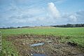
Bowl barrow 510 m south east of Lodmore Farm
-

Bowl barrow 550 m south of Bristol Plain Farm: part of a linear round barrow cemetery
-
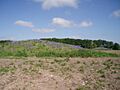
Bowl barrow 610 m northwest of Whitestown Farm
-
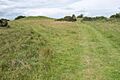
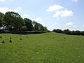
Bowl barrow on Stock Hill: part of the Stock Hill round barrow cemetery
-
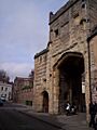
Browne's Gate
-
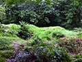
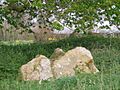
Burial chamber (remains of), Murtry Hill, Orchardleigh Park
-
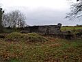
Charterhouse lead works
-
Fenny Castle Cross: a medieval wayside cross 20 m north west of Castle Farm, Castle
-
Market cross in the market place
-
Medieval standing cross 50 m west of St Peter's Church
-
Medieval standing cross 80 m south of St Mary's Church
-
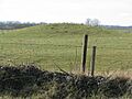
Pair of bowl barrows 350 m NNE of Whitnell Corner
-
Part of the Hospital of St Mary Magdalene, Magdalene Street
-
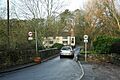
Rode Bridge
-
The Abbot's Fish House and fishponds
-
The Devil's Bed and Bolster long barrow
-
The tithe barn
-
Tithe Barn, Pilton
-
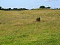
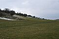
Round barrow on Beacon Hill
-
Round barrows in and near Wright's Piece


.jpg)


.jpg)


.jpg)


_-_geograph.org.uk_-_694664.jpg)

.jpg)


