Seaford, Delaware facts for kids
Quick facts for kids
Seaford, Delaware
|
|
|---|---|
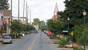
High Street in Seaford
|
|
| Etymology: Seaford, East Sussex in England | |
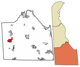
Location of Seaford in Sussex County, Delaware.
|
|
| Country | |
| State | |
| County | Sussex |
| Incorporated | April 6, 1865 |
| Named for | Seaford, East Sussex |
| Government | |
| • Type | Mayor-council |
| Area | |
| • Total | 5.16 sq mi (13.37 km2) |
| • Land | 5.09 sq mi (13.19 km2) |
| • Water | 0.07 sq mi (0.18 km2) |
| Elevation | 23 ft (7 m) |
| Population
(2020)
|
|
| • Total | 7,957 |
| • Density | 1,562.65/sq mi (603.31/km2) |
| Time zone | UTC−5 (Eastern (EST)) |
| • Summer (DST) | UTC−4 (EDT) |
| ZIP Code |
19973
|
| Area code(s) | 302 |
| FIPS code | 10-64320 |
| GNIS feature ID | 214626 |
| Website | www.seafordde.com |
Seaford is a city in Sussex County, Delaware, United States. It is located along the Nanticoke River. In 2020, about 7,957 people lived there.
Seaford is the largest city that is completely inside Sussex County. It is also part of the Salisbury, Maryland-Delaware Metropolitan Statistical Area.
Contents
History of Seaford
Seaford got its name from a town called Seaford, East Sussex in England.
How Seaford Became Part of Delaware
Long ago, the land where Seaford is now was part of Maryland. This included towns like Bridgeville and Greenwood. An old map mistake caused confusion about the border between Maryland and Delaware. The original plan was for the border to be at Cape Henlopen. But because of the mistake, the line was drawn differently.
If the original plan had been followed, Seaford would be in Maryland today! After many years, the border was finally set by surveyors Mason and Dixon in 1763. This is why Seaford is now in Delaware.
Downtown Improvements
Seaford is one of seven "Main Street" communities in Delaware. These communities work to make their downtown areas better. From 1999 to 2000, Seaford's downtown got a big makeover. Things like landscaping, new sidewalks, and streetlights were added. This helped to keep the historic look of the area.
Geography and Climate
Seaford covers about 5.16 square miles (13.37 square kilometers). Most of this area is land, with a small part being water.
Seaford's Weather
Seaford is located near the Atlantic Ocean. This means the ocean helps to keep the weather mild. Seaford has a humid subtropical climate. This means it has hot, humid summers and cool winters.
The hottest temperature ever recorded in Seaford was 104°F (40.0°C) on July 22, 2011. The coldest temperature was -13°F (-25.0°C) on January 28, 1987.
| Climate data for Seaford, 1991–2020 simulated normals (26 ft elevation) | |||||||||||||
|---|---|---|---|---|---|---|---|---|---|---|---|---|---|
| Month | Jan | Feb | Mar | Apr | May | Jun | Jul | Aug | Sep | Oct | Nov | Dec | Year |
| Mean daily maximum °F (°C) | 45.1 (7.3) |
47.7 (8.7) |
54.9 (12.7) |
66.0 (18.9) |
74.5 (23.6) |
83.1 (28.4) |
87.8 (31.0) |
85.6 (29.8) |
79.9 (26.6) |
69.4 (20.8) |
58.5 (14.7) |
49.5 (9.7) |
66.8 (19.3) |
| Daily mean °F (°C) | 36.1 (2.3) |
37.9 (3.3) |
44.6 (7.0) |
55.0 (12.8) |
64.2 (17.9) |
73.2 (22.9) |
78.1 (25.6) |
75.7 (24.3) |
69.8 (21.0) |
58.6 (14.8) |
48.2 (9.0) |
40.3 (4.6) |
56.8 (13.8) |
| Mean daily minimum °F (°C) | 27.0 (−2.8) |
28.2 (−2.1) |
34.5 (1.4) |
44.2 (6.8) |
53.8 (12.1) |
63.1 (17.3) |
68.2 (20.1) |
65.8 (18.8) |
59.7 (15.4) |
48.0 (8.9) |
37.8 (3.2) |
31.1 (−0.5) |
46.8 (8.2) |
| Average precipitation inches (mm) | 3.47 (88.23) |
2.94 (74.66) |
4.18 (106.27) |
3.48 (88.41) |
3.85 (97.88) |
4.14 (105.07) |
4.32 (109.85) |
4.72 (119.81) |
4.49 (114.17) |
4.21 (106.98) |
3.30 (83.78) |
3.89 (98.68) |
46.99 (1,193.79) |
| Average dew point °F (°C) | 26.2 (−3.2) |
27.0 (−2.8) |
32.5 (0.3) |
42.3 (5.7) |
53.1 (11.7) |
62.6 (17.0) |
67.5 (19.7) |
66.6 (19.2) |
60.8 (16.0) |
49.8 (9.9) |
38.5 (3.6) |
31.3 (−0.4) |
46.5 (8.1) |
| Source: PRISM Climate Group | |||||||||||||
People of Seaford
| Historical population | |||
|---|---|---|---|
| Census | Pop. | %± | |
| 1860 | 624 | — | |
| 1870 | 1,304 | 109.0% | |
| 1880 | 1,542 | 18.3% | |
| 1890 | 1,462 | −5.2% | |
| 1900 | 1,724 | 17.9% | |
| 1910 | 2,108 | 22.3% | |
| 1920 | 2,141 | 1.6% | |
| 1930 | 2,468 | 15.3% | |
| 1940 | 2,804 | 13.6% | |
| 1950 | 3,087 | 10.1% | |
| 1960 | 4,430 | 43.5% | |
| 1970 | 5,537 | 25.0% | |
| 1980 | 5,256 | −5.1% | |
| 1990 | 5,689 | 8.2% | |
| 2000 | 6,699 | 17.8% | |
| 2010 | 6,928 | 3.4% | |
| 2020 | 7,957 | 14.9% | |
| U.S. Decennial Census | |||
In 2020, the population of Seaford was 7,957 people. The city has grown over the years. In 2000, there were 6,699 people living in Seaford.
The average age of people in Seaford in 2000 was 38 years old. About 25% of the population was under 18 years old.
Arts and Culture

Seaford has many interesting places and events that show its history and culture.
Historic Places to Visit
Many buildings and sites in Seaford are listed on the National Register of Historic Places. This means they are important historical sites. Some of these include:
- The Building at 200–202A High Street
- The Building at 218 High Street
- The Building at High and Cannon Streets
- Burton Hardware Store
- J. W. Cox Dry Goods Store
- First National Bank of Seaford
- Hearn and Rawlins Mill
- Lawrence
- Maston House
- Jesse Robinson House
- Edgar and Rachel Ross House
- Gov. William H. Ross House
- St. Luke's Protestant Episcopal Church
- Seaford Station Complex
- Sussex National Bank of Seaford
Fun Things to Do and See
- Nanticoke River Arts Council/Gallery 107: A place to see local art.
- Seaford Christmas Parade: A fun parade during the holiday season.
- Nanticoke River Walk: A path along the Nanticoke River in downtown Seaford. It's great for walking.
- Seaford Museum: Located in an old post office, it tells the story of Seaford.
- Ross Mansion and Plantation: This was the home of former Delaware Governor William H. H. Ross. You can see the main house, old farm equipment, and other historic buildings.
- Nanticoke Riverfest: A festival in July that includes floating on inner tubes in the Nanticoke River.
- AFRAM Festival: A celebration of African American culture held in August.
Seaford District Library
The Seaford District Library started in the early 1900s. It has many books and items, and also serves as a community center.
Parks and Recreation
Seaford has several parks and places for outdoor activities:
- Kiwanis Park: A memorial park.
- Gateway Park: A park with brick sidewalks and a fountain at the entrance to downtown.
- Soroptimist Park: Located at Williams Pond, it has a playground and a covered area.
- Nutter Park: Features a playground and basketball courts.
- Williams Pond Park: A baseball park used by the Nanticoke Little League.
- Sports Complex: Includes a community-built playground called Jay's Nest and softball fields.
- Hooper's Landing Golf and Country Club: A public golf course with 18 holes, a pool, and tennis courts.
Education
The Seaford School District serves the city of Seaford and the nearby community of Blades. The district covers about 82 square miles. It has four elementary schools, one middle school, and one high school. Around 3,500 students from pre-kindergarten to 12th grade attend these schools.
Media
Radio
WGBG 92.7 FM broadcasts from just outside Seaford.
Television
WDPB-TV 64 is the only TV station that starts in Seaford. It is part of WHYY-TV in Philadelphia and is an affiliate of PBS.
Newspapers
The Seaford Star is a weekly newspaper. It is published by Morning Star Publications, which also publishes other local papers. You can find more information at starpublications.online.
City Services and Transportation
Getting Around Seaford
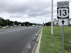
- Main Roads: U.S. Route 13 runs north and south through Seaford. Delaware Route 20 runs east and west. These roads connect Seaford to other towns like Bridgeville, Laurel, and Millsboro.
- Airports: The closest airport with flights is Wicomico Regional Airport in Salisbury, Maryland. Smaller public airports are in Laurel and Georgetown.
- Buses: DART First State operates bus routes in Seaford. Route 212 connects Seaford to Georgetown and Delmar. Route 903F runs in a loop around Seaford.
- Trains: Freight trains serve Seaford. The Delmarva Central Railroad runs north-south. The Maryland and Delaware Railroad connects to it and heads west into Maryland.
Utilities
The City of Seaford Electric Department provides electricity to homes and businesses in the city. The Public Works department provides water and sewer services. Natural gas service in Seaford is provided by Chesapeake Utilities.
Famous People from Seaford
- Lee F. Booth, a well-known person in the aerospace industry.
- Delino DeShields, a former professional baseball player.
- Ricky Elliott, an American racing driver.
- Stephanie Hansen, a state senator in Delaware.
- Horace G. Knowles, a U.S. Ambassador.
- Mike Neill, a former Olympic baseball player.
- Lovett Purnell, a former American football player.
- Darnell Savage, an American football player.
Images for kids
See also
 In Spanish: Seaford (Delaware) para niños
 | Precious Adams |
 | Lauren Anderson |
 | Janet Collins |


