Segula Island facts for kids
Quick facts for kids Segula Island |
|
|---|---|

Segula Island: 9
|
|
| Highest point | |
| Elevation | 3,806 ft (1,160 m) |
| Prominence | 3,806 ft (1,160 m) |
| Geography | |
| Location | Aleutian Islands, Alaska, US |
| Topo map | USGS Rat Islands |
| Geology | |
| Mountain type | Stratovolcano |
| Volcanic arc/belt | Aleutian Arc |
| Last eruption | Unknown |
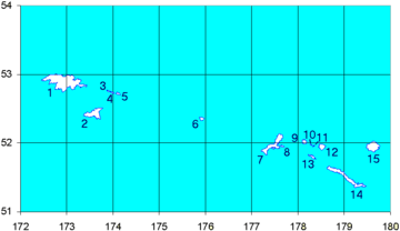
Segula Island (called Chiĝulax̂ in the Aleut language) is a small island in the western Aleutian Islands of Alaska, US. It is part of a group of islands known as the Rat Islands. The island is actually a stratovolcano, which is a tall, cone-shaped volcano built up by many layers of hardened lava and ash. This volcano is known as Segula Volcano.
Segula Island is about 3 to 4 miles (4.8 to 6.4 kilometers) wide. It is located about 15 miles (24 km) east of Kiska Island. The island is home to a very large group of auklets, which are small seabirds. This is one of only nine such large bird colonies found in the entire Aleutian Island chain.
Segula Island's Weather
Like the other Rat Islands, Segula Island has a cool and wet Oceanic climate. This means it gets a lot of rain and fog, and the temperatures are usually mild. It often snows on and off from October all the way through May.
The Rat Islands are also in the path of strong storms that come from the Pacific Ocean. These storms can bring very powerful winds, sometimes blowing as fast as 100 miles (160 km) per hour!
Plants and Animals of Segula Island
Segula Island has plants that are typical for the Aleutian Islands. You can find lots of moss and lichens growing there. There are also areas covered in heath, which is a type of shrubby plant.
Other plants on the island include sedges (grass-like plants), different kinds of grass, and fungi. You might also see various herbs, ferns, and beautiful flowering plants. Some of these flowers are the Narcissus anemone, lupines, and orchids.
See also
 In Spanish: Isla Segula para niños
 | Dorothy Vaughan |
 | Charles Henry Turner |
 | Hildrus Poindexter |
 | Henry Cecil McBay |

