Sgairneach Mhòr facts for kids
Quick facts for kids Sgairneach Mhòr |
|
|---|---|

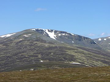
Sgairneach Mhòr seen from The Sow of Atholl, 3 km to the east.
|
|
| Highest point | |
| Elevation | 991 m (3,251 ft) |
| Prominence | 182 m (597 ft) |
| Listing | Munro, Marilyn |
| Naming | |
| English translation | Big Rocky Hillside |
| Language of name | Gaelic |
| Geography | |
| Location | Perth and Kinross, Scotland |
| Parent range | Grampian Mountains |
| OS grid | NN598731 |
| Topo map | OS Landranger 42, OS Explorer 394 |
Sgairneach Mhòr is a Scottish mountain. It is part of a group of seven tall mountains called Munros. These mountains are found near the Pass of Drumochter in Scotland. People sometimes call them the “A9 Munros” because they are close to that road. Sgairneach Mhòr is about 13 kilometers (8 miles) southwest of Dalwhinnie. It is also about 4 kilometers (2.5 miles) east of a big lake called Loch Ericht.
Contents
What is Sgairneach Mhòr?
Sgairneach Mhòr is a very tall mountain. It stands 991 meters (3,251 feet) high. It is known as a Munro, which is a Scottish mountain over 3,000 feet (914.4 meters) tall. It is also a Marilyn, meaning it stands out from the land around it by at least 150 meters (492 feet).
A Mountain with a Special Name
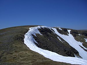
The mountain's name, Sgairneach Mhòr, comes from the Gaelic language. It means “Big Rocky Hillside.” This name fits the mountain well! You can see its rocky side from the Pass of Drumochter. This rocky area is a large, bowl-shaped hollow called a corrie. It is named Coire Creagach and often holds snow late into the spring. Sgairneach Mhòr is special because it has more stony areas than other mountains in its group. This makes it look very striking.
Where is Sgairneach Mhòr?
Sgairneach Mhòr is located west of the A9 road. This area is historically known as Druim Uachdair, meaning "the ridge of the upper ground."
Exploring the Slopes and Ridges
The mountain has wide slopes on its southern side. These slopes include two smaller peaks: Màm Bàn (919 meters) and Meallan Buidhe (879 meters). They lead down to a valley with a stream called Allt Shallainn. This stream flows into Loch Garry.
Two clear ridges stretch out from the top of Sgairneach Mhòr. One goes north and the other east. These ridges surround Coire Creagach. This corrie is rocky but not too steep. It offers a fun climb to the summit. The top of the mountain is a flat area that runs from southwest to northeast. The highest point is easy to find. It's at the northeast end, near the edge of Coire Creagach. There you will find an OS trig point (a marker used for mapping) surrounded by a low stone wall that helps block the wind.
The eastern ridge connects Sgairneach Mhòr to another nearby hill called The Sow of Atholl. This ridge is narrow near the summit as it curves around Coire Creagach. Then it gets wider as it slopes down to a lower point, or col, about 650 meters high. This eastern ridge is a popular way to climb the mountain. Another path is the northeast ridge, which is steeper and rough in some places. The western side of the mountain has wide slopes that curve around the top of Coire Dhomhain. They lead down to a col that connects to the nearby Munro, Beinn Udlamain. All the water from Sgairneach Mhòr flows south into the River Garry and then the Tummel. These rivers eventually join the River Tay and reach the sea at the Firth of Tay.
The Summit and Its History
For a long time, maps showed the summit of Sgairneach Mhòr in the wrong place. Early maps from 1891 placed the summit about 500 meters (1,640 feet) southwest of its true spot. This old spot was actually almost 30 meters (98 feet) lower than the real top! The correct summit location was noted in maps from 1921. However, some later maps still showed the old, incorrect position by mistake. Now, maps show the correct highest point.
How to Climb Sgairneach Mhòr
Climbing Sgairneach Mhòr is not too hard. You can start your walk from the top of the Drumochter Pass on the A9 road. This starting point is already quite high, at 462 meters (1,516 feet) above sea level.
Starting Your Adventure
From the starting point, you cross the railway tracks. Then you walk along a good path on the north side of a stream called Allt Coire Dhomhain. After about two kilometers (1.2 miles), you leave the path and cross the stream. There is no bridge, so you might need to step carefully over the water. Then, you walk south through open land covered in heather until you reach the eastern ridge. You follow this ridge all the way to the summit. If the stream is very full (in "spate"), you can walk higher up into Coire Dhomhain and then climb the steeper northern ridge instead.
Combining Mountains for a Big Day
Many hikers like to climb Sgairneach Mhòr with other mountains nearby. The SMC suggests climbing it with Beinn Udlamain. Because you start high up at Drumochter Pass, you can even hike around the whole valley. This means you could climb The Sow of Atholl, Sgairneach Mhòr, Beinn Udlamain, and A' Mharconaich all in one day without it being too tiring.
Amazing Views from the Top
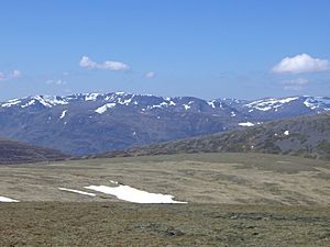
From the summit of Sgairneach Mhòr, the best view is to the west. You can see the impressive Ben Alder group of mountains. It's a truly amazing sight!
 | Leon Lynch |
 | Milton P. Webster |
 | Ferdinand Smith |


