
Shardlow facts for kids
Quick facts for kids Shardlow |
|
|---|---|
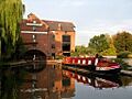
 Main wharf, Shardlow |
|

Shardlow
|
|
| OS grid reference | SK437302 |
| Civil parish |
|
| District |
|
| Shire county | |
| Region | |
| Country | England |
| Sovereign state | United Kingdom |
| Post town | DERBY |
| Postcode district | DE72 |
| Police | Derbyshire |
| Fire | Derbyshire |
| Ambulance | East Midlands |
| EU Parliament | East Midlands |
Shardlow is a village in Derbyshire, England. It is about 6 miles (10 km) southeast of Derby. It is also 11 miles (18 km) southwest of Nottingham. Shardlow is part of the civil parish of Shardlow and Great Wilne. It is also in the South Derbyshire district. The village is very close to the border with Leicestershire. The River Trent forms this border to the south.
Shardlow was once a very important river port. This was in the late 1700s and early 1800s. Goods were moved here between the River Trent and the Trent and Mersey Canal. Because it was so busy, people called it "Rural Rotterdam" and "Little Liverpool". Today, Shardlow is known as Britain's best example of a canal village. It has over 50 Grade II listed buildings. Many old public houses still stand in the Shardlow Wharf Conservation Area.
Contents
History of Shardlow
Shardlow is located on the River Trent. This river is easy to travel on by boat up to this point. Because of this, people have lived and worked in the area for a very long time. Evidence of human activity dates back to 1500 BC.
Ancient Discoveries
In 1999, a 12-foot (3.7 m) long Bronze Age log boat was found. It was discovered at a nearby gravel pit. This boat, from about 1300 BC, is now in the Derby Museum and Art Gallery. Five years later, a bronze sword was found in the same quarry. There is also a Stone Age burial mound at Lockington. An Iron Age settlement was found between Shardlow and the river. Later, Roman items were found at Great Wilne.
Early Village Life
In 1009, King Æþelræd Unræd signed a special document. This document set the boundaries for the area of Westune. The land included what we now call Shardlow. It also included Great Wilne, Church Wilne, and other nearby places. The King gave his minister special rights over this land.
The village is mentioned in the Domesday Book as Serdelau. This name means a settlement near a mound with a notch. Historians have found about 20 different spellings for the village's name. The oldest building still standing in Shardlow is thought to be the "Dog & Duck" public house.
Shardlow as a Transport Hub

The River Trent below Shardlow can be traveled on by boat all the way to the Humber Estuary. The River Soar also joins the Trent about 2 miles (3.2 km) downstream. This made Shardlow an important place for moving goods. Large ships and boats traded cargo with packhorse trails. These trails carried goods across the region. The money made from charging fees for goods passing through the port helped a rich businessman, Leonard Fosbrooke, build Shardlow Hall. During the English Civil War, battles were fought here. People wanted to control this important transport spot.
The old road from London to Manchester (now the A6) goes through the village. It crosses the Trent at Cavendish Bridge. This bridge was designed by James Paine. Before the bridge, a rope-pulled ferry boat was used. This ferry replaced earlier medieval bridges. These wooden bridges were destroyed by floods between 1140 and 1309. The river often changed its path due to floods.
Paine's original bridge was built between 1758 and 1761. It cost 2 shillings and 6 pence (about 12.5p) for carriages to cross. The bridge was used until 1947. In that year, a flood swept its supports away. The British Army quickly built a temporary bridge. The current bridge was built in 1957. Today, part of Paine's old bridge still stands. It has the old toll charges carved into it.
The Busy Port of Shardlow

In the 1700s, a discovery helped Shardlow's port grow. People found that heating flint could turn reddish clay into shiny white pottery. This led to many goods being shipped through Shardlow. Pottery from Stoke-on-Trent was sent all over the world.
James Brindley built the Trent and Mersey Canal from 1766 to 1777. His idea was to connect England's four main rivers: the Mersey, Trent, Severn, and Thames. He created another big canal port like Shardlow at Stourport-on-Severn. Brindley's canal reached Shardlow in 1770. It joined the River Trent near Great Wilne. The River Derwent also joined there. Because of this, Shardlow quickly became a major river port. It was a place where goods were moved from large river barges to smaller canal narrow boats. Shardlow later became the main office for the Trent and Mersey Canal.
By 1816, the port had 12 canal basins. The warehouses around them were rebuilt as trade grew. By 1820, the larger buildings we see today were in place. Each wharf and warehouse had a special job. Some stored coal, timber, iron, cheese, corn, or salt. Other businesses grew up around the port. These included boat builders, rope makers, and stables for horses. There were also offices, including the canal's head office. Two families, the Soresburys and the Suttons, became very rich from the port.
The port was so important that the village was called "Rural Rotterdam" and "Little Liverpool". The number of people living in Shardlow grew from 200 in 1780 to 1,306 in 1841.
Changes from the 1840s to 1950s

The arrival of the Midland Railway in the 1840s changed things. Trains began to carry goods, which meant less business for the canal. By 1861, the population of Shardlow had dropped to 945. By 1886, the port was almost empty. In 1947, the government took over the waterways. Shardlow was no longer officially a port.
In 1816, several local areas built a large building in Shardlow. This building was for people who needed help. It was called a "workhouse". Over time, more people needed help. The building was made bigger in 1838–1839. It could then hold up to 230 people.
Shardlow and Great Wilne were part of the Aston-on-Trent area until 1838. But with the new workhouse, the communities decided to build their own church. St James's Church opened in 1839. After this, Shardlow became its own parish.
In 1905, the workhouse started to become a hospital. New buildings were added. After World War II, it became "The Grove" hospital. This hospital closed in 2005 and was taken down in 2007.
Shardlow Today

The last boat carrying grain to Shardlow arrived in the early 1950s. In 1957, the stables that housed over 100 towing horses were taken down. Some smaller warehouses were also removed over the next 20 years.
In 1975, a group called the Trent & Mersey Canal Society helped save the area. They got the Shardlow Wharf Conservation Area created. This area now protects over 50 Grade II listed buildings.
Today, Shardlow is a small village. It is still considered Britain's best example of a canal village. Most of the old warehouses and port buildings have been changed. They are now used for other businesses or as homes.
Notable People from Shardlow
- Dave Brailsford, a famous British cycling coach, was born here.
- Hugh Trevor Lambrick, an archaeologist and historian.
- W. A. Robotham from Rolls-Royce was born in the village.
- Elizabeth Scott, Duchess of Buccleuch, a Scottish noblewoman, was born here.
- Robert de Shardlow (1200-c.1257), a judge and official, was born here and took his name from the village.
- Adam Slack, guitarist and founder of the rock band The Struts.
Images for kids
-
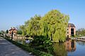
Main wharf, Shardlow
-
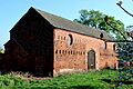
An old barn, built for storing grain before the arrival of the canal
-
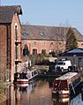
The oldest surviving warehouse in Shardlow, built in the 1770s. It is now the Shardlow Heritage Centre.
-
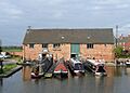
Former warehouses in Shardlow, now used as a boatyard
-
Originally Mill No.2 from 1780, now known as The Clock Warehouse
See also
 In Spanish: Shardlow para niños
