Shore Road, Belfast facts for kids
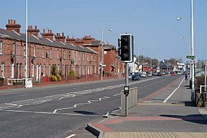
The Shore Road is a main road and a busy area with homes and shops in north Belfast and Newtownabbey in Northern Ireland. It's part of the A2 road, which connects Belfast to the beautiful County Antrim coast.
Contents
History of the Shore Road
The Shore Road is one of Belfast's oldest roads. It was first mentioned in a city survey way back in 1757! Back then, the name "Shore Road" covered a bigger area, including what we now call York Street.
During the time of the Industrial Revolution, when many factories were built, the lower parts of Shore Road and York Street grew a lot. Many factories were built here.
One famous factory on York Street was Gallaher's Tobacco factory. It's not there anymore, as the building was taken down.
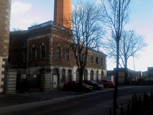
One of the few old factory buildings still standing is Jennymount Mill, near York Road. This building was renamed the Lanyon Building after its architect, Charles Lanyon. It was reopened in 2002 as an office block. For a long time, this area was mainly home to working-class Protestant families.
The areas further along the Shore Road towards Newtownabbey are newer. Some housing areas, like Shore Crescent and the Rathcoole estate, were built in the 1960s and later. Many people from the crowded areas at the bottom of the road moved to these new estates. A lot of the homes along the road have been updated over the years.
Exploring Areas of the Shore Road
York Street: City Link
York Street connects Belfast City Centre to the Shore Road. Royal Avenue, a main street in the city centre, becomes York Street after crossing Donegall Street. This street used to be the edge of the dockside area called Sailortown. York Street was once a very busy living area, but much of it was changed to build new roads like the M2 and the Westlink. The New Lodge and Tiger's Bay areas are just north of York Street.
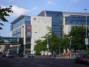
York Street is home to the University of Ulster's Belfast campus. This campus has the university's art and design school and is part of the city's Cathedral Quarter. This area gets its name from the nearby St Anne's Cathedral. Next to the university is Cathedral Eye Clinic, a top centre for eye care.
Other places you'll find on York Street include the Cityside Shopping Centre, which has big stores like Tesco and Asda. There's also St Paul's Church of Ireland and Yorkgate railway station. In the past, the street was known for the Co-operative buildings, built between 1911 and 1932. These buildings had many shops, the Co-op's main office, and their restaurant and ballroom, the Orpheus. It also had the Gallaher's tobacco factory, which was the biggest cigarette factory in the world when it opened in 1896.
York Road: Community Hub
York Street continues to Limestone Road, where it changes name to York Road. This area has a police station, which helps keep North Belfast safe. York Road also has several places of worship, including a Salvation Army mission, Alexandra Presbyterian Church, Jennymount Methodist Church, and the York Road Baptist Community.
Alexandra Park is a public park in the York Road area. While this area is mainly home to one community, it is next to the Newington area, which has a different community background. Because of this, Alexandra Park has a special fence, sometimes called a peace line, running through it. This helps keep the two communities separate when using the park. In late 2011, a gate was added to this fence, allowing access for a limited time.
Tiger's Bay: A Historic Area
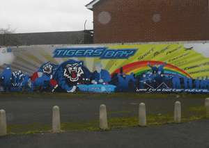
Tiger's Bay is a community area focused on upper North Queen Street. Even though it's not directly on the Shore Road, the two areas run side-by-side and are connected by smaller streets. It started in the 1800s with simple homes for workers at the Harland and Wolff shipyard. Like York Street and York Road, Tiger's Bay was badly damaged during the Belfast Blitz in World War II.
Tiger's Bay is known for its strong community spirit and has had some disagreements with the nearby New Lodge and Newington areas in the past. People have tried to improve relations between the communities. While some residents prefer to keep the peace lines for safety, projects have been started in Tiger's Bay to replace old murals and graffiti with more positive community artwork.
Grove and Fortwilliam: Local Life
The Shore Road officially begins just after the junction with Skegoneill Avenue. The area at the end of York Road and the start of Shore Road is often called Grove, because of the names of some local streets. The name Grove is seen in local places like the Grove Leisure Centre (now closed), Grove Housing Association, and the Grove Tavern. The Grove area has always been a place for industry, now mainly focusing on animal feed. Parts of this area have been updated recently and it's home to the Grove Wellbeing Centre. This building combines health services, a leisure centre, and a library all in one place. Like much of the Shore Road, the Grove area is mainly home to working-class families.
As you go further along the Shore Road, you reach the Fortwilliam area, named after local streets. Fortwilliam has a large Asda store and a smaller Lidl. Churches here include Seaview Presbyterian Church and Fortwilliam Gospel Hall. Near Fortwilliam is the Mount Vernon estate, a large area of social housing. This estate started being built in 1949 and includes two big apartment blocks, Ross House and Mount Vernon House, built in 1966. The estate got its name from the original Mount Vernon House, a grand home built for a Belfast merchant, which was named after George Washington's home.
Lowwood to Greencastle: Residential Areas
The areas after Fortwilliam, called Lowwood and Donegall Park Avenue, are mostly residential, meaning they have lots of homes. This area also has Loughside Park, a public park and sports area looked after by Belfast City Council.
Shore Crescent is a housing estate located east of Mount Vernon and Lowwood. It was one of several areas built in the late 1960s to rehouse people from the inner-city Sailortown area, which was being redeveloped. The Greencastle area that follows is a mixed community with both Catholic and Protestant residents. It includes St Mary's Catholic Church and the Whitewell Metropolitan Tabernacle. Greencastle used to have a police station, but it has since closed.
The Whitewell Road connects the Shore Road to the Antrim Road. This area also has a mix of communities, though they are largely separate. There have been some community disagreements in the area since the mid-1990s. After Whitewell comes Bawnmore, an area mainly settled by nationalist/republican families. During the time of conflict known as the Troubles, Bawnmore was often targeted and was heavily protected. This has changed since the Northern Ireland peace process began, though some tension remains.
Newtownabbey: Beyond Belfast
Belfast ends and Newtownabbey begins on the Shore Road in an area that used to be the village of Whitehouse. Rathcoole, a large estate, is here, along with the smaller Merville Garden Village. This area includes the Abbey Centre and other nearby shopping parks, making it the main shopping spot in Newtownabbey. Places of worship include Whitehouse Presbyterian Church and St. John's Church of Ireland. Glas-na-Bradan Glen, a wooded area near Rathcoole, is also close to the Shore Road.
The Shore Road then goes through Whiteabbey, another historic village that is part of Newtownabbey. The Whiteabbey part of the road mostly has private homes. The road then passes through Jordanstown, with the University of Ulster campus nearby. Around this area, one side of the road is right next to the sea. This is different from Belfast and lower Newtownabbey, where the M2 and the Belfast–Larne railway line separate the Shore Road from Belfast Lough. Several parks and green spaces are kept along these parts of the Shore Road, like Hazelbank Park, Rushpark, Glen Park, and Jordanstown Loughshore Park, which also has a caravan park. After Greenisland, the road changes its name to the Belfast Road as it reaches Carrickfergus. The A2 road continues all the way to Limavady under different names.
Sporting Life on Shore Road
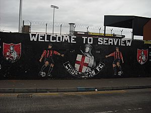
The Shore Road and its nearby areas are home to several football clubs. The biggest is NIFL Premiership club Crusaders F.C., whose home ground, Seaview, is on the road. The club moved to Seaview in 1921. Since 2013, Seaview has also been home to Newington Youth F.C.. Skegoneill Avenue, a street almost opposite Seaview, connects the Shore Road to the Antrim Road and has the home stadium of Brantwood F.C., also known as Skegoneill Avenue. Further up in the Greencastle area, the Shore Road playing fields are home to Northern Amateur Football League teams Grove United F.C. and Malachians F.C..
The Tiger's Bay area has the Midland Boxing Club. Famous boxers like Carl Frampton, a former world champion, trained here. Rinty Monaghan, another world champion boxer from the nearby Sailortown area, has a statue on York Street to remember him.
Fortwilliam golf club is also close to the Shore Road. It's located at Downview Avenue and crosses Grays Lane, a road connecting the Shore Road and the Antrim Road in the Greencastle area. Grove Swimming Baths opened in the early 1960s and had the only international standard 25-metre swimming pool in all of Ireland at the time. However, it closed when the Grove Wellbeing Centre opened, and the building was taken down in 2013.
Education on Shore Road
Several secondary schools are located in and around the Shore Road. These include Castle High School on Fortwilliam Park, Hazelwood Comprehensive College on Whitewell Road, Newtownabbey Community High School, and Belfast High School in Jordanstown.
Primary schools on the Shore Road include Seaview Primary School in the Grove area, St Mary's Star of the Sea in the Greencastle area, and Lowwood Primary on Sheringhurst Park. In Newtownabbey, you'll find Whitehouse Primary School and Whiteabbey Primary School. The Loughshore Educational Resource Centre, which helps students with behavioural needs, is also on the Shore Road.
The main Belfast campus of Ulster University is on York Street, which is a continuation of the Shore Road into the city centre. A campus of the Northern Regional College, a college for further education, is also located in the Whiteabbey section of the Shore Road.
Getting Around: Transport
Public transport along the Shore Road is provided by the Metro buses, part of Translink. Buses connect Belfast City Centre to areas in Newtownabbey like Monkstown, Rathcoole, Carnmoney, and Ballyduff.
Ulsterbus services for areas beyond Newtownabbey also use the Shore Road. The road is also served by the Yorkgate and Whiteabbey railway stations. Both stations are on the Belfast–Larne railway line, and Yorkgate is just one stop away from the main train station in Belfast.
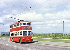
In the past, Belfast trams and later Belfast trolleybuses ran along the Shore Road. Trains from York Street used to go to towns like Larne, Portrush, Ballycastle, and Derry.
The M2 motorway runs next to the Shore Road for much of its length. You can find Junctions one and two of the M2 on the Shore Road. Junction One is at Fortwilliam, and Junction Two is at Greencastle.


