
Sloan Peak facts for kids
Quick facts for kids Sloan Peak |
|
|---|---|

Sloan Peak at sunset, taken from Mount Pugh
|
|
| Highest point | |
| Elevation | 7,835 ft (2,388 m) |
| Prominence | 3,875 ft (1,181 m) |
| Geography | |

Sloan Peak
Location in Washington (state)

Sloan Peak
Location in the United States
|
|
| Parent range | North Cascades |
| Topo map | USGS Sloan Peak |
| Climbing | |
| First ascent | July 30, 1921 by Harry Bedal, Nels Skaar |
| Easiest route | Snow climb/rock scramble, class 3 |

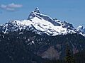
Sloan Peak is a tall mountain in the North Cascades of Washington state. It stands about 7,835 feet (2,388 meters) high. This mountain is located about 40 miles (64 km) east of Everett, Washington. It is also 12 miles (19 km) southwest of Glacier Peak, which is a type of volcano called a stratovolcano.
Sloan Peak sits between the north and south forks of the Sauk River. It is part of the Mt. Baker Snoqualmie National Forest. The top of the mountain is about 4 miles (6.4 km) east of the Mountain Loop Highway. People sometimes call Sloan Peak the "Matterhorn of the Cascades." This is because it has a very sharp, high peak. It stands out because it rises so much higher than the land around it. You can easily see Sloan Peak from many places in the North Cascades. On both its east and southwest sides, the peak rises over a mile (1.6 km) from the valley floor.
Climbing Sloan Peak
The most common way to climb Sloan Peak is called the "Corkscrew Route." It gets this name because it winds its way around the mountain. The climb starts on the north side of the peak. Climbers then cross the Sloan Glacier to reach the east side of the South Face. From there, the route continues to turn around the peak. It finally reaches the summit by climbing the Upper West Face.
To get to the start of the climb, people usually use Forest Service Road No. 48 and Trail No. 649. The trail crosses the North Fork of the Sauk River. There isn't a bridge, but sometimes a log can be used to cross. The total climb goes up about 5,935 feet (1,809 meters). This route involves climbing on snow and glaciers. It also includes some rock scrambling, which is like climbing rocks using your hands and feet. Other, more difficult routes are available on different sides of Sloan Peak.
Mountain History
Sloan Peak was first climbed on July 30, 1921. The first people to reach the top were Harry Bedal and Nels Skaar. They used the Corkscrew Route to make their way up the mountain.
Mountain Weather
Sloan Peak is in a marine west coast climate zone. This means it has mild, wet winters and cool, dry summers. Most of the weather systems come from the Pacific Ocean. They move northeast towards the Cascade Range.
As these weather systems reach the North Cascades, the mountains force the air upward. This process is called Orographic lift. When the air rises, it cools down and drops its moisture. This moisture falls as rain or snow on the Cascades. Because of this, the western side of the North Cascades gets a lot of precipitation. This is especially true during the winter months, when most of it falls as snow.
In winter, the weather is often cloudy. But in summer, high-pressure systems over the Pacific Ocean often bring clear skies. The snow in this area tends to be wet and heavy due to the ocean's influence. This can lead to a high risk of avalanches.
How Mountains Form
The North Cascades have very rugged land. You can see jagged peaks, tall spires, long ridges, and deep valleys carved by glaciers. These amazing shapes were created by geological events that happened millions of years ago. These events caused big changes in the land's height and led to different climates.
The Cascade Mountains started forming millions of years ago, during the late Eocene Epoch. This was when the North American Plate was slowly moving over the Pacific Plate. This movement caused a lot of volcanic activity. Also, small pieces of the Earth's crust, called terranes, came together to form the North Cascades about 50 million years ago.
Later, during the Pleistocene period, which was over two million years ago, glaciers played a big role. These huge sheets of ice moved forward and backward many times. As they moved, they scraped and shaped the land. They left behind piles of rock and debris. The river valleys in this area have a "U" shape. This shape was created by these recent glaciers. The rising of the land (called orogeny) and cracks in the Earth's crust (called faulting) worked with glaciation. Together, these processes created the tall peaks and deep valleys we see in the North Cascades today.
Images for kids
-
Sloan Peak from the southeast side.

