SoDo, Seattle facts for kids
Quick facts for kids
SoDo, Seattle
|
|
|---|---|
|
Seattle Neighborhood
|
|

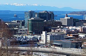
Seattle SoDo seen from Rizal Park
|
|

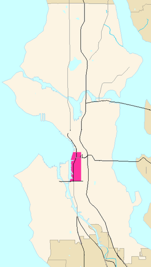
SoDo Highlighted in Pink
|
|
| Country | United States |
| State | Washington |
| County | King |
| City | Seattle |
| Named for | South of the Dome South of Downtown |
| Time zone | UTC−8 (PST) |
| • Summer (DST) | UTC−7 (PDT) |
| Zip Code |
98154
|
| Area Code | 206 |

SoDo, also known as SODO, is a lively neighborhood in Seattle, Washington. It's a big part of the city's Industrial District, which is an area with many factories, warehouses, and businesses.
SoDo is bordered by South King Street to the north, which is where Pioneer Square begins. To the south, you'll find South Spokane Street and more of the Industrial District. The Duwamish River is to the west, and across it is West Seattle. To the east, you'll find the Metro Transit's Downtown Seattle Transit Tunnel and the SoDo Busway, leading to the International District.
SoDo got its name from being "South of the Dome". The Kingdome was a large stadium that was torn down in 2000. After that, people started saying the name meant "South of Downtown". This name became popular in the 1990s.
Contents
What's in SoDo?
SoDo is home to Seattle's main sports stadiums. This makes it a very exciting place, especially on game days!
Sports Stadiums in SoDo
- T-Mobile Park: This is where the Major League Baseball team, the Seattle Mariners, play their home baseball games.
- Lumen Field: Built where the Kingdome used to be, this stadium is home to several teams:
- The NFL's Seattle Seahawks play their home football games here.
- The XFL's Seattle Sea Dragons also play football here.
- The Major League Soccer team, Seattle Sounders FC, plays their home soccer matches.
- The National Women's Soccer League team, Seattle Reign FC, also plays their soccer matches here.
In the early 2000s, the Mariners had a popular saying, "SoDo Mojo," which helped make the neighborhood's name even more famous.
SoDo's Unique Vibe
SoDo's name sounds a lot like "SoHo" in New York City. In the 1970s, SoHo became famous when artists moved into old factories and turned them into cool living and studio spaces.
SoDo has gone through a similar change. Many old warehouses are still used for their original purpose. But others have been changed into spaces for artists, art galleries, and many different kinds of businesses. As you travel further south, you'll see more light manufacturing, warehouses, and large retail stores.
How Do People Get Around in SoDo?
SoDo has several important roads and good public transportation.
Main Roads in SoDo
The main roads that run north and south are First Avenue S., Fourth Avenue S., and Alaskan Way S. Roads that run east and west include S. Lander Street, Holgate Street, Edgar Martínez Drive S., and S. Royal Brougham Way.
Did you know that the very beginning of Interstate 90 is in SoDo? This highway stretches over 3,020 miles (4,860 km) all the way to Boston, Massachusetts!
Public Transportation Options
SoDo is well-connected by public transit:
- 1 Line Light Rail: Sound Transit operates a light rail service through the neighborhood. It stops at two stations:
- SODO Station at Lander Street.
- Stadium Station at Royal Brougham Way.
- SODO Busway: This special bus lane runs along 5th Avenue South. It carries bus routes from King County Metro and Sound Transit Express, making it easy to get around the city.
 | William L. Dawson |
 | W. E. B. Du Bois |
 | Harry Belafonte |

