1 Line (Sound Transit) facts for kids
Quick facts for kids 1 Line |
|
|---|---|
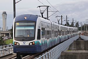
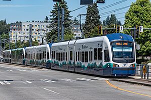
A four-car Series 1 train on the 1 Line approaching SeaTac/Airport station
|
|
| Overview | |
| Other name(s) |
|
| Owner | Sound Transit |
| Locale | Seattle, Washington, U.S. |
| Termini | Lynnwood City Center (north) Angle Lake (south) |
| Stations | 23 |
| Service | |
| Type | Light rail |
| System | Link light rail |
| Operator(s) | King County Metro |
| Rolling stock |
|
| Daily ridership | 78,944 (2024, weekdays) |
| Ridership | 28,910,300 (2024) |
| History | |
| Opened | July 18, 2009 |
| Technical | |
| Line length | 33.15 mi (53.35 km) |
| Number of tracks | 2 |
| Character | At grade, elevated, and underground |
| Track gauge | 4 ft 8 1⁄2 in (1,435 mm) standard gauge |
| Electrification | 1,500 V DC |
| Operating speed | 55 mph (89 km/h) |
The 1 Line is a special train line in Seattle, Washington, USA. It's part of Sound Transit's Link light rail system. This line has 23 stations and travels about 33 miles (53 km) between Lynnwood City Center in the north and Angle Lake in the south.
The 1 Line connects many important areas. These include Lynnwood, Mountlake Terrace, Shoreline, the University District, Downtown Seattle, the Rainier Valley, and the Seattle–Tacoma International Airport. In 2024, over 28.9 million people rode the 1 Line. On an average weekday, nearly 80,000 passengers used it.
Trains on the 1 Line run for 20 hours a day on weekdays and Saturdays. During busy times, trains arrive as often as every six minutes. On Sundays and holidays, service runs for 18 hours. Each train can have three or more cars. Each car can carry 194 passengers, with 74 seats. There's also space for wheelchairs and bicycles.
You can pay for your ride using an ORCA card, paper tickets, or a mobile app. Sound Transit uses a "proof-of-payment" system. This means you need to have a valid ticket or card before you get on the train. Fare ambassadors and transit police check tickets randomly. All stations have ticket machines, public art, bike parking, and connections to buses. Some stations also have park-and-ride lots where you can leave your car.
The idea for this train line was approved by voters in 1996. Construction started in 2003. The line first opened on July 18, 2009. It connected Westlake in Downtown Seattle to Tukwila International Boulevard near the airport. It was later extended to SeaTac/Airport station in December 2009. Then, it went north to the University of Washington in March 2016 and south to Angle Lake in September 2016. The line was called the "Red Line" for a short time. In 2021, it became the "1 Line" when it was extended to Northgate.
The first big extension across counties, going north to Lynnwood, opened on August 30, 2024. Another extension south to Federal Way is planned to open in 2026. The 2 Line will connect Seattle to the Eastside suburbs. It will link up with the 1 Line in 2025, creating a bigger train network. Future plans will divide the current 1 Line into two different lines: the 1 Line from Ballard to Tacoma, and the 3 Line from Everett to West Seattle.
Contents
History of the 1 Line
Early Transit Ideas in Seattle
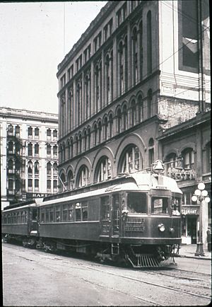
Public transportation in Seattle began in 1884 with horse-drawn streetcars. Soon, electric streetcars and cable cars took over. These helped new neighborhoods grow around the city. Later, interurban railways connected Seattle to nearby cities like Everett and Tacoma. But these trains couldn't compete with cars, especially after a major highway was built. By 1941, streetcars were replaced by electric buses.
Over the years, many ideas for a faster train system in Seattle were suggested. But they were often too expensive or voters didn't approve them. For example, in 1911, a planner named Virgil Bogue proposed a 41-mile (66 km) system of underground and elevated trains. Voters said no. The Seattle Center Monorail, built for the 1962 World's Fair, also had plans for expansion that didn't happen.
In the late 1960s, a group called Forward Thrust suggested a 47-mile (76 km) train system. It would connect Downtown Seattle to many neighborhoods and suburbs. The government offered to pay a lot of the cost if local voters approved some taxes. But voters didn't approve the plan in 1968 or 1970. The money that was set aside for Seattle's trains ended up going to Atlanta, Georgia, to help build their train system.
Planning the Light Rail System
After the Forward Thrust plans failed, a new agency called Metro Transit was created in 1972. Its job was to manage the bus system and plan for future trains. In the 1980s, they looked at different ideas for trains. They decided to build a tunnel in Downtown Seattle that buses could use first, and then trains later.
In 1986, a regional group officially supported a light rail plan. They suggested a system by 2020, including a line from Seattle to the airport. In 1990, the state government created a regional transit board. This board included leaders from King, Pierce, and Snohomish counties. Their goal was to make the regional transit plan happen. Many Seattle city leaders wanted the train to go through the Rainier Valley. This was an area that needed more economic help.
The Central Puget Sound Regional Transit Authority, later called Sound Transit, was formed in 1993. They were tasked with creating a regional transit plan for voters to approve. They proposed a 70-mile (110 km) light rail network. This plan included a surface line through the Rainier Valley and tunnels under Downtown Seattle. Voters did not approve this plan in 1995. So, the light rail line was made shorter, to 25 miles (40 km), between the University District and the airport. Voters finally approved this smaller plan in November 1996. This meant sales taxes and vehicle taxes would increase to pay for it.
Sound Transit studied different routes for the project, which was named "Central Link." In 1999, they chose the final path. It would go between the University District and the airport. Parts would be at ground level in Tukwila, the Rainier Valley, and SoDo. Other parts would be in tunnels under Beacon Hill, First Hill, Capitol Hill, and Portage Bay.
Budget Problems and Delays
The Central Link project was supposed to open in 2006 and cost $1.9 billion. But in 2000, auditors found these numbers were not realistic. New leaders at Sound Transit presented a new plan. The opening date was pushed back to 2009, and the cost was estimated at $3.8 billion. Building the tunnel under Portage Bay was put on hold because it was too expensive.
In January 2001, Sound Transit approved the new budget and schedule. They also got a $500 million grant from the government. This money was for building an "initial segment" of the project. This first part was shortened to 14 miles (23 km) between Downtown Seattle and a station in Tukwila near the airport. The rest of the routes to the airport and University District were planned as separate projects later.
In November 2001, Sound Transit approved building the shorter Central Link project. Property was bought in the Rainier Valley starting in March 2002. But two legal challenges delayed construction. In November 2002, a court ruled in favor of Sound Transit. Another issue was a tax initiative that threatened funding, but it was found to be unconstitutional. The city of Tukwila also asked for a route change, which was approved in 2002. This helped the project move closer to starting construction.
Building and Testing the Line
Sound Transit received its $500 million federal grant in October 2003. A groundbreaking ceremony was held in SoDo on November 8, 2003. Construction contracts were given out in 2004 and 2005. The costs were actually a bit lower than Sound Transit expected. Work began on all parts of the system.
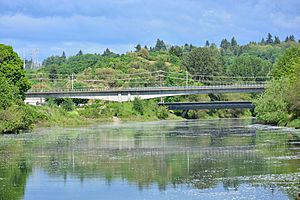
Building the bridge over the Duwamish River in Tukwila was delayed. Over 900 ancient artifacts from the Coast Salish people were found in February 2005. Work stopped for six weeks while archaeologists studied the findings. The first train tracks were laid on August 18, 2005, in the SoDo area. A month later, the downtown transit tunnel closed for two years. It needed to be updated to allow light rail trains to use it.
Digging for the Beacon Hill tunnel and station began in 2005. Two giant tunnel boring machines started digging in early 2006. They created two tunnels between SoDo and the Rainier Valley.
The SODO and Stadium stations were finished in May 2006. Testing of the light rail trains began in the SoDo area in March 2007. Testing expanded to the re-opened downtown transit tunnel in September 2007. It was later extended to the Rainier Valley after the Beacon Hill tunnel was finished in 2008. The elevated tracks in Tukwila, including crossings over major highways and the Duwamish River, were completed in 2007.
During construction in the Rainier Valley, Sound Transit and Seattle offered $50 million to help businesses affected by the work. Building the light rail along Martin Luther King Jr. Way South also meant moving power lines underground. Sidewalks, street crossings, and landscaping were also improved.
Opening and First Extensions
The Central Link line opened on July 18, 2009. A big celebration attracted over 92,000 riders during the first weekend of free service. Trains started running on the 13.9-mile (22.4 km) section between Westlake and Tukwila International Boulevard. A bus shuttle connected Tukwila to the airport. The 1.7-mile (2.7 km) extension to SeaTac/Airport station opened on December 19, 2009. This replaced the bus shuttle to the airport.
In 2010, Sound Transit added special equipment to reduce noise in Tukwila and the Rainier Valley. The noise levels were too high and caused complaints from people living nearby. A disagreement with the Rainier Valley construction company was settled in 2011. This meant the project's total cost was $117 million under its budget. The new train service in the Rainier Valley also encouraged new building projects.
In 2015, Central Link train service became more frequent, running every 6 minutes during busy times. This was to get ready for the University Link extension. The line was extended north to University of Washington station, through Capitol Hill station, on March 19, 2016. This was a $1.8 billion, 3.15-mile (5.07 km) tunnel. The extension opened six months earlier than planned. The opening celebrations brought 67,000 people on the first day. Sound Transit added more three-car trains to handle the increased number of riders. The line was also extended 1.6 miles (2.6 km) south from Sea-Tac Airport to Angle Lake station on September 24, 2016. This new station included a large parking lot.
The escalators at Capitol Hill and University of Washington stations had some problems in the first two years. These problems happened because regular escalators were used instead of stronger ones designed for busy train stations. A new company was hired to maintain them. New stairs and walkways were also added for other ways to get around. In October 2018, a section of the line in Tukwila was closed for repairs. Cracks were found in the tracks on a bridge over Interstate 5.
New Names and Northern Extensions
In September 2019, Central Link was renamed the "Red Line." This was part of a plan by Sound Transit to rename all its lines. But two months later, the agency said it would consider a new name. People complained because "Red Line" sounded like "redlining". This was a historical practice that unfairly affected people in the Rainier Valley. A new name, the "1 Line" (colored green), was announced in April 2020 and started being used in September 2021.
In January 2020, Sound Transit started a big construction project called "Connect 2020." This project meant trains had to use only one track in the Downtown Seattle Transit Tunnel. This was needed for work on the East Link Extension. A temporary platform was built at Pioneer Square for passengers to transfer. Sound Transit used four-car trains running every 13–15 minutes. They also limited bikes on trains through downtown. The project finished in late March. But train frequency stayed reduced because of the COVID-19 pandemic. Service was cut to every 30 minutes in April. It was partly restored in September to every 8 minutes during busy times. The first of the new "Series 2" trains, made by Siemens, started service in May 2021.
The third expansion of the 1 Line was a 4.3-mile (6.9 km) northern extension. It went from University of Washington station to the Northgate neighborhood. This project was funded in 2008 and construction began in 2012. A 3.5-mile (5.6 km) tunnel was dug between July 2014 and September 2016. It created two tunnels for the extension's three stations. The part of the tunnel under the University of Washington campus needed special measures. These measures reduced electrical interference for lab equipment. The Northgate extension opened on October 2, 2021. It added three stations to the north end of the line.
Service on the 1 Line was sometimes interrupted in 2022 and 2023. This was due to emergency repairs and maintenance. These caused sections to close or trains to run on a single track with fewer trips. The special bumpy strips on the edge of platforms at some stations were replaced. On April 27, 2023, the ceiling of Westlake station was damaged during surface construction. This caused two weeks of service problems in Downtown Seattle. A crossing at Royal Brougham Way was replaced in August 2023 because it had sunk. This project caused delays for trains.
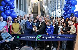
The Lynnwood Link Extension opened on August 30, 2024. It added four stations to the line as it went into Snohomish County. This 8.5-mile (13.7 km) extension cost $3 billion to build. It is expected to carry 50,000 passengers each day. On the same day, University Street station was renamed to Symphony. This was to avoid confusion with the University of Washington stations. The full 2 Line between Seattle and the Eastside opened before the Lynnwood extension. It provides access to a new train maintenance facility.
Route of the 1 Line
The 1 Line starts at Lynnwood City Center station in Lynnwood. This is a big bus hub. Trains leave this station on elevated tracks. They go over a creek and a bus yard. Then, they follow the west side of Interstate 5. The tracks go down into a trench before crossing over Interstate 5 in Mountlake Terrace.
The 1 Line reaches Mountlake Terrace station and continues on elevated tracks. It crosses into Shoreline and King County. The tracks then go down to the ground level. They follow the east side of Interstate 5 to Shoreline North/185th station. This station has a two-story parking garage. The 1 Line continues south to the elevated Shoreline South/148th station. This will be a future connection point for another train line. The line then goes into Seattle on elevated tracks. It passes Jackson Park and the future Pinehurst station. After a short return to ground level, the tracks go over several streets near the Northgate Mall and reach Northgate station.
From Northgate station, the line stays elevated for a bit. Then, it goes underground into the Northgate Link tunnel in the Maple Leaf neighborhood. This 3.4-mile (5.5 km) tunnel travels southeast through Roosevelt. It stops at a station near Northeast 65th Street. Then, it goes south to U District station before reaching the University of Washington campus. The tunnel goes southeast under the campus to University of Washington station, near Husky Stadium. From there, it heads south in the University Link tunnel. It crosses under the Montlake Cut and State Route 520. Then, it turns southwest.
The tunnel goes up Capitol Hill and passes under two parks. Then, it turns south to enter Capitol Hill station. The tunnel makes a gradual turn west and crosses under Interstate 5. It joins the Downtown Seattle Transit Tunnel.
The downtown transit tunnel used to be shared by trains and buses. It travels west under Pine Street through Westlake station. Then, it goes south on 3rd Avenue through Symphony and Pioneer Square stations in Downtown Seattle. The tunnel ends at International District/Chinatown station. This station is next to King Street Station, where other trains stop. The 1 Line then travels south through SoDo along the east side of the SODO Busway. The SoDo section has two stations, Stadium and SODO. It also has several crossings with gates.
From SODO station, the tracks go up to an elevated path. This path travels east along South Forest Street, passing the line's train yard and maintenance building. The elevated track goes over Airport Way and then under Interstate 5. It then enters the Beacon Hill tunnel.
The Beacon Hill tunnel travels about one mile (1.6 km) under Beacon Hill. It serves a station at Beacon Avenue South. Trains leave the tunnel on the east side of the hill. They turn southeast and approach the elevated Mount Baker station. Trains then go down from Mount Baker station onto the middle of Martin Luther King Jr. Way South. They run at ground level with special signals at 28 street crossings. The 1 Line goes through the Rainier Valley and stops at three ground-level stations: Columbia City, Othello, and Rainier Beach. Then, it leaves Seattle.
The line enters Tukwila and crosses west over Interstate 5 and a main railroad line. It then turns south over East Marginal Way South. The 1 Line continues south over the Duwamish River. It travels non-stop through Tukwila on a 4.7-mile (7.6 km) elevated path. This path runs along the west sides of State Route 599 and Interstate 5 towards Southcenter Mall. Then, it turns west along State Route 518. The line passes through Tukwila International Boulevard station, which has a large parking lot. It then turns south into the middle of the Airport Expressway towards SeaTac. Light rail trains continue along the east side of Seattle–Tacoma International Airport. They stop at SeaTac/Airport station near the airport's terminals. Finally, they reach Angle Lake station, where the line ends.
The 1 Line is called a "light rail" line. But some experts also call it a "light metro" system. This is because parts of it are separated from roads, and it uses longer trains than typical light rail systems in America. It is 33.15 miles (53.35 km) long. About 7 miles (11 km) of its tracks are at ground level. These ground-level parts include some sections along highways that are separated from other roads.
Stations Along the 1 Line
Stations on the 1 Line are usually about one mile (1.6 km) apart. Their platforms are 380 feet (120 m)* to fit four-car trains. Some stations are underground or elevated, with stairs, escalators, and elevators connecting to the street. Other stations are at street level. All stations have bus connections, ticket machines, signs showing when the next train will arrive, public art, and places to park bicycles. Stations are also designed to be safe, with clear views, emergency phones, and cameras.
All stations connect to local bus routes. These include buses from King County Metro, Community Transit, and Sound Transit Express. Metro Flex is a special shuttle service that started in 2019 at five stations. It lets you request a ride using an app. As of 2024, seven stations have public park-and-ride lots. For other stations, Sound Transit encourages people to get there by bus, walking, or biking.
| Code | Station | City | Type | Image | Opened | Connections and notes |
|---|---|---|---|---|---|---|
| 40 | Lynnwood City Center | Lynnwood | Elevated | August 30, 2024 | Park and ride: 1,670 stalls | |
| 41 | Mountlake Terrace | Mountlake Terrace | Elevated | August 30, 2024 | Park and ride: 890 stalls | |
| 42 | Shoreline North/185th | Shoreline | At-grade | August 30, 2024 | Park and ride: 494 stalls | |
| 43 | Shoreline South/148th | Elevated | August 30, 2024 | Park and ride: 500 stalls | ||
| 45 | Northgate | Seattle | Elevated | October 2, 2021 | Park and ride: 1,525 stalls | |
| 46 | Roosevelt | Underground | October 2, 2021 | |||
| 47 | U District | Underground | October 2, 2021 | |||
| 48 | University of Washington | Underground | March 19, 2016 | |||
| 49 | Capitol Hill | Underground | March 19, 2016 | Connects with First Hill Streetcar | ||
| 50 | Westlake | Underground | July 18, 2009 | Connects with Seattle Center Monorail and South Lake Union Streetcar | ||
| 51 | Symphony | Underground | July 18, 2009 | |||
| 52 | Pioneer Square | Underground | July 18, 2009 | Connects with Washington State Ferries, King County Water Taxi, and Kitsap Fast Ferries | ||
| 53 | International District/Chinatown | Underground | July 18, 2009 | Connects with Amtrak, Sounder commuter rail, and First Hill Streetcar | ||
| 54 | Stadium | At-grade | July 18, 2009 | Connects with Greyhound | ||
| 55 | SODO | At-grade | July 18, 2009 | |||
| 56 | Beacon Hill | Underground | July 18, 2009 | |||
| 57 | Mount Baker | Elevated | July 18, 2009 | |||
| 58 | Columbia City | At-grade | July 18, 2009 | |||
| 60 | Othello | At-grade | July 18, 2009 | |||
| 61 | Rainier Beach | At-grade | July 18, 2009 | |||
| 63 | Tukwila International Boulevard | Tukwila | Elevated | July 18, 2009 | Park and ride: 662 stalls | |
| 64 | SeaTac/Airport | SeaTac | Elevated | December 19, 2009 | Connects with Seattle–Tacoma International Airport | |
| 65 | Angle Lake | Elevated | September 24, 2016 | Park and ride: 1,120 stalls |
How the 1 Line Operates
1 Line trains run for 20 hours a day from Monday to Saturday, starting at 5:00 AM and ending at 1:00 AM. On Sundays and holidays, they run for 18 hours, from 6:00 AM to midnight. During busy weekday mornings (6:00 AM to 9:30 AM) and afternoons (3:00 PM to 6:30 PM), trains arrive every eight minutes. During midday and evening hours on weekdays, and all day on weekends, trains come every 10 minutes. In the early morning and late night, trains run every 15 minutes.
A trip from one end of the line (Lynnwood) to the other (Angle Lake) takes 73 minutes. A trip between SeaTac/Airport station and Downtown Seattle takes 38 minutes. Before the light rail, a bus route covered the SeaTac–Westlake area. That bus trip took 32 minutes, but it was less frequent and could get stuck in traffic. Also, the bus stops were closer to the airport terminal. Some late-night northbound trains end at Beacon Hill station instead of going all the way through Downtown Seattle. This allows for earlier overnight maintenance on some parts of the tracks.
How Many People Ride the 1 Line?
| Year | Ridership | %± |
|---|---|---|
| 2009 | 2,501,211 | — |
| 2010 | 6,989,504 | 179.4% |
| 2011 | 7,812,433 | 11.8% |
| 2012 | 8,699,821 | 11.4% |
| 2013 | 9,681,432 | 11.3% |
| 2014 | 10,937,883 | 13% |
| 2015 | 11,530,411 | 5.4% |
| 2016 | 19,121,621 | 65.8% |
| 2017 | 23,186,633 | 21.3% |
| 2018 | 24,416,411 | 5.3% |
| 2019 | 25,075,922 | 2.7% |
| 2020 | 9,660,736 | -61.5% |
| 2021 | 11,512,650 | 19.2% |
| 2022 | 23,706,210 | 105.9% |
| 2023 | 26,883,140 | 13.4% |
| 2024 | 28,910,300 | 7.5% |
| Source: Sound Transit | ||
In 2024, over 28.9 million people rode 1 Line trains. On an average weekday, about 83,187 passengers rode the line. Ridership is counted by special infrared sensors on the trains. These sensors automatically record how many people get on and off.
The number of riders on the 1 Line has grown a lot since it opened in 2009. Back then, about 15,500 people rode it each weekday. In 2010, ridership was lower than expected because of an economic downturn. But it quickly grew, passing 25,000 daily riders in 2012 and 35,000 in 2015.
When the University Link extension opened in March 2016, daily ridership jumped by 66 percent in just one month. It averaged 66,203 daily riders by the end of that year. A record of 82,361 riders was set on April 8, 2016, thanks to a baseball game and a big comic convention. This record was broken again five months later, with 101,000 riders, partly due to football and baseball games.
Ridership dropped to 9.7 million total passengers in 2020. This was a 61 percent decrease from 2019, mainly because of the COVID-19 pandemic and service cuts. But ridership grew again after the Northgate Link Extension opened in 2021 and more offices reopened. The line set a new single-day record of 115,600 riders on July 11, 2023, during a major baseball game. This record was broken twice more that month, reaching 136,800 riders on July 23. This was due to several big events happening at the same time, including concerts and more baseball games. In September 2024, the average Saturday ridership reached 82,000, which was even higher than the weekday average of 79,000 riders.
How to Pay for Your Ride
The 1 Line uses a "proof-of-payment" system. This means you need to have a valid ticket or pass before you get on the train. There are no turnstiles at the stations. You can buy paper tickets from machines at the stations. You can also use an ORCA card, which you can load with money or passes. There's also a mobile app for tickets. Fare ambassadors check for valid tickets on trains or in the station areas. If you don't have a valid ticket, they will give you information and warnings.
Before 2021, fare inspectors and police checked tickets and gave warnings or fines. After fare inspectors were removed, about 42 percent of passengers in January 2022 did not pay their fare. A new program with fare ambassadors started in September 2022. It has a multi-step system where fines start after your third violation.
Fares are a flat rate of $3 for adults. It's $1 for people who qualify for reduced fares, like seniors or people with disabilities. Children aged 18 and younger ride for free. Before 2024, fares were based on how far you traveled, ranging from $2.25 to $3.50 for adults. If you used an ORCA card, you had to tap it when you got on and when you got off to calculate the fare. You can transfer from other types of transportation, like buses or water taxis, using your ORCA card. Since September 2022, rides for passengers under 19 have been free as part of a statewide program.
Trains and Equipment
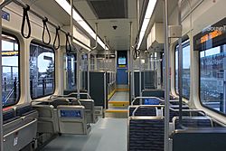
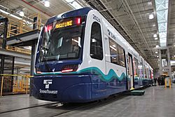
The first trains used on the 1 Line were called "Series 1." There were 62 of these trains, made in Japan by Kinkisharyo. These trains have a "low-floor" design, which means most of the floor is close to the ground, making it easy to get on and off. Each Kinkisharyo train car has 74 seats and can carry 194 passengers (seated and standing) at normal capacity. For short distances, they can carry up to 252 passengers per car.
Each train car is 95 feet (29.0 m) long and 8.7 feet (2.7 m) wide. They have controls at both ends, so they can travel in either direction. About 70 percent of the interior is low-floor, while the rest is slightly raised with small stairs. Each car has four doors on each side. There are also fold-up seats for wheelchairs and hooks for two bicycles above luggage areas. Usually, 1 Line trains are made of three or four cars linked together. Before 2021, trains were usually two or three cars long.
These trains can go as fast as 58 miles per hour (93 km/h), but they usually travel at 35 mph (56 km/h) on ground-level sections and 55 mph (89 km/h) on elevated or tunnel sections. The Link system uses a special control system to make sure trains don't go over the speed limit for any area.
Trains get their electricity from overhead wires, which carry 1,500 volts of direct current (DC). This is converted to alternating current (AC) on the train. Sound Transit chose 1,500 V DC instead of the more common 750 V DC to reduce the number of electrical stations needed along the line. These stations are about one mile (1.6 km) apart.
Sound Transit first ordered 31 trains in 2003. They added four more in 2005 for the extension to the airport. These trains were put together in Everett, Washington, to meet "Buy America" rules. They were delivered between 2006 and 2008. Another 27 trains were ordered in 2009 for the University Link extension and delivered from 2010 to 2011.
The 1 Line trains are stored and maintained at a 26-acre (10.5 ha) facility in SoDo. This facility opened in 2007 and cost $74 million to build. It can hold 105 train cars. King County Metro operates and maintains the 1 Line trains under a contract with Sound Transit.
In September 2016, Sound Transit ordered 122 new "Series 2" trains from Siemens Mobility. These trains are a type of S700. They are for future extensions to Northgate, Lynnwood, the Eastside, and Federal Way. Another 30 trains were added to the order in April 2017, making a total of 152 new trains. The first Series 2 train arrived in June 2019. It has the same number of seats but a wider walkway and other new features. The first Siemens trains started service on May 14, 2021. A smaller maintenance facility in Bellevue opened in 2021 to hold 96 more trains. A third facility is planned near Federal Way for future system growth.
Future Plans for the 1 Line
Sound Transit has plans for future Link light rail extensions. These plans were approved by voters in 2008 (Sound Transit 2) and 2016 (Sound Transit 3). These extensions are scheduled to open in stages between 2021 and 2040. The Northgate Link extension opened on October 2, 2021. It added three stations to the north end of the 1 Line in Seattle. The 2 Line opened in 2024. This new line goes to Bellevue and Redmond. It will be extended west to Seattle in 2025.
As part of the Sound Transit 2 program, the 1 Line will be extended south to Federal Way by 2026. In 2032, the 3 Line to West Seattle will begin service. It will temporarily run between Alaska Junction and SODO station. When an extension to Ballard opens by 2039, the current 1 Line will be split into two lines. The 1 Line will run from Ballard to Tacoma, going through the Rainier Valley and Sea-Tac Airport. The 3 Line will run from Lynnwood (and later Everett) to West Seattle. Two new stations are also planned along the current 1 Line route. They will open in 2031 at South Graham Street in the Rainier Valley and Boeing Access Road in northern Tukwila.
See also
 In Spanish: Línea 1 (Tren Ligero de Seattle) para niños
 | Isaac Myers |
 | D. Hamilton Jackson |
 | A. Philip Randolph |


