
South Table Mountain (Colorado) facts for kids
Quick facts for kids South Table Mountain |
|
|---|---|

View looking east from the top of Lookout Mountain
|
|
| Highest point | |
| Elevation | 6,338 ft (1,932 m) |
| Prominence | 475 ft (145 m) |
| Isolation | 1.75 mi (2.82 km) |
| Geography | |

South Table Mountain
Location in Colorado
|
|
| Location | Jefferson County, Colorado, U.S. |
| Parent range | Front Range foothills |
| Topo map | United States Geological Survey 7.5' topographic map Golden, Colorado |
| Geology | |
| Mountain type | Mesa |
| Climbing | |
| First ascent | February 14, 1859 by George Andrew Jackson, Thomas L. Golden and members of Chicago Company |
| Easiest route | South slope via Quaker Street |
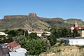
South Table Mountain is a flat-topped hill called a mesa. It's part of the Front Range of the Rocky Mountains in North America. The highest point, called Castle Rock, is about 6,338 feet (1,932 meters) high. It's located just east of Golden, in Jefferson County, Colorado, United States.
Contents
What is South Table Mountain?
The most special thing about South Table Mountain is its flat top. This flat top was made by ancient lava flows from a time called the Paleocene epoch. A nearby mountain, North Table Mountain, looks similar. They are separated by Clear Creek.
South Table Mountain is a popular place for fun and beautiful views near Denver. Most of the mountain is protected as Jefferson County Open Space. Its most famous part is Castle Rock. This is a smaller, higher hill that sticks out from the northwest side of the mesa.
The Geology of the Mountain
South Table Mountain sits on top of layers of sedimentary rocks. These rocks are from the Denver Formation. They formed between the late Cretaceous period and the early Paleocene epoch. Scientists have even found a layer on its slopes that shows the boundary between the Cretaceous and Paleocene times. This boundary is important because it marks when the dinosaurs disappeared.
Two large, cliff-forming lava flows make up the flat top of South Table Mountain. These lava flows have a special pattern called columnar jointing. The lava likely came from a volcanic vent called the Ralston Dike, about 4 miles northwest. These lava flows are very old, about 62 to 64 million years old. They are usually called basalt, but can also be classified as latite or shoshonite. They contain minerals like augite, plagioclase, and olivine.
Special Minerals: Zeolites
Both North and South Table Mountain are famous for their many types of zeolite minerals. These minerals are found in small holes, called vesicles, within the second lava flow. Some of the zeolites found here include analcime, thomsonite, mesolite, and chabazite. You can see excellent examples of these Table Mountain zeolites at the nearby Mines Museum of Earth Science.
History of South Table Mountain
Long ago, American Indian tribes used South Table Mountain. There are still signs of their presence on its top. The first recorded climbs of the mesa happened in 1859 during the Colorado Gold Rush.
In 1906, William H. and Clyde L. Ashworth built the first Castle Rock Resort. This was a cafe on top of Castle Rock. Visitors would ride burros up a trail to get there. After some damage in 1907, Charles F. Quaintance reopened it in 1908. He added a new cafe, burro rides, and a road. Later, in 1913, a lighthouse, dance hall, and a funicular (a type of cable railway) were added.
The resort's popularity faded when other mountain parks opened. The funicular rails were even used to help with the war effort in World War I in 1918. The resort later burned down in 1927. In the 1910s and 1920s, the city of Denver dug for gravel on the mountain's northeast side.
In 1935, the Works Progress Administration built the Colorado Amphitheater on the mountain's southern side. Later, in 1957, there were plans to build a theme park called Magic Mountain. But people living nearby protested, and the park was built elsewhere. Over time, Jefferson County bought or protected much of South Table Mountain. Today, most of it is open to the public. Some southern parts are used by the Colorado State Patrol and the National Renewable Energy Laboratory.
Important Places on the Mountain
Even if they aren't always on official maps, some places on South Table Mountain have special names:
- Castle Rock: This is the famous hill at the northwest end. It was first known as Table Rock.
- Slaughterhouse Gulch: A valley on the northern slope. It was probably named after farms that used to be in the Coors Brewery valley.
- Long Gulch: A long valley along Quaker Street on the south side.
- Crystal Springs: Natural springs (places where water comes out of the ground) near the top of Long Gulch.
Wildlife on the Mountain
Many animals have lived on the mesa over time. These include rattlesnakes, coyotes, mountain sheep, cougars, deer, and elk. Most of these animals, except for mountain sheep, still live there today. The area is known for having many rattlesnakes, which are considered the most dangerous wildlife. Coyotes are often seen but usually stay away from people. Cougars are rarely spotted by hikers. The animals you are most likely to see are elk, deer, coyotes, and many different kinds of birds.
Fun Facts About Climbing the Mountain
- First Ascent — The first known climb by a person was on February 14, 1859. It was done by gold discoverer George A. Jackson, his partner Thomas L. Golden, and others from the Chicago Company. They were hunting mountain sheep on top of the mesa.
- Fastest Ascent — The fastest known time to climb to the top of Castle Rock is 14 minutes and 59 seconds. This record was set by Andrew Terrill on November 2, 2016. He ran from the Washington Avenue Bridge at Clear Creek to the summit.
- First Automobile Ascent — The first car to drive up the mountain was a Stanley Steamer in 1908. George Hering drove it with four passengers and camera equipment.
- Fastest Automobile Ascent — This was the same as the first car ascent. It took 12 minutes and 45 seconds from 13th Street and Washington Avenue. A picture of the car and passengers on top of Castle Rock was even published in the newspaper!
- Helicopter Ascent — A helicopter made an emergency landing on top of Castle Rock in the 1970s. This event also made the front page of the local newspaper.
Images for kids
-
South Table Mountain with its capping lava flows, as seen from the Colorado School of Mines campus in Golden. Castle Rock is the prominence to the left of center.

