
Spire Mountain facts for kids
Quick facts for kids Spire Mountain |
|
|---|---|

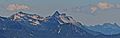
ENE aspect, from West Cady Ridge
|
|
| Highest point | |
| Elevation | 6,213 ft (1,894 m) |
| Prominence | 1,853 ft (565 m) |
| Isolation | 3.92 mi (6.31 km) |
| Parent peak | Gunn Peak (6,244 ft) |
| Geography | |

Spire Mountain
Location in Washington (state)

Spire Mountain
Location in the United States
|
|
| Location | Snohomish County, Washington, US |
| Parent range | Cascade Range |
| Topo map | USGS Baring |
| Type of rock | gabbro |
| Climbing | |
| First ascent | May 1934, Dwight Dean, Kenneth Chapman |
| Easiest route | class 4-5 |
Spire Mountain is a tall peak in the Cascade Range in Washington. It stands about 6,213 feet (1,894 meters) high. You can find it in Snohomish County, not far from the town of Index.
This mountain is part of the Wild Sky Wilderness. It is managed by the Mount Baker-Snoqualmie National Forest. Water from the mountain flows into the Skykomish River.
Spire Mountain actually has a few different peaks. The highest one, the Northwest Spire, was first climbed in May 1934 by Dwight Dean and Kenneth Chapman. The Central Spire was first climbed in 1938 by Karl Boyer, Lyman Boyer, and David Lind. The Southeast Spire is also quite high, at about 6,185 feet.
Understanding Spire Mountain's Climate
Spire Mountain is located in a special climate zone called the marine west coast climate. This means it gets a lot of moisture from the Pacific Ocean. Most of the weather systems start over the Pacific and move towards the Cascade Range.
When these weather systems hit the tall peaks of the Cascades, they are forced to rise. This process is called Orographic lift. As the air rises, it cools down and drops its moisture. This causes a lot of rain or snowfall on the west side of the mountains.
Because of the ocean's influence, the snow here is often wet and heavy. This can lead to a high risk of avalanches. It rarely gets extremely cold (below 0°F or -18°C) or very hot (above 80°F or 27°C) in this area.
During winter, the weather is usually cloudy. But in summer, high-pressure systems over the Pacific Ocean often bring clear skies. The best time to visit or climb Spire Mountain is usually from July to September.
How Spire Mountain Was Formed: Geology Basics
The North Cascades area, where Spire Mountain is located, has very rugged land. You can see sharp peaks, tall spires, long ridges, and deep valleys carved by glaciers. These amazing shapes were created by geological events that happened millions of years ago.
The Cascade Mountains started forming a very long time ago, during the late Eocene Epoch. This was when the North American Plate slowly moved over the Pacific Plate. This movement caused a lot of volcanic activity, creating new rock.
Also, small pieces of the Earth's outer layers, called terranes, crashed into North America. These pieces helped build the North Cascades about 50 million years ago.
Later, during the Pleistocene period (which started over two million years ago), huge sheets of ice called glaciers moved across the land. These glaciers repeatedly advanced and then melted back. As they moved, they scraped and shaped the landscape, leaving behind rock debris.
The "U"-shaped valleys you see in the area are a result of these glaciers. The combination of land uplift (when the land pushes up) and faulting (when cracks form in the Earth's crust) along with glaciation has created the tall peaks and deep valleys of the North Cascades.
- Spire Mountain weather forecast
Images for kids
-
Southeast aspect of Spire Mountain seen from Scorpion Mountain
-
North aspect of Spire Mountain (centered) seen from Gothic Basin.

