
Stalbridge facts for kids
Quick facts for kids Stalbridge |
|
|---|---|
 St Mary's Church |
|
 Street map |
|

Stalbridge
|
|
| Population | Expression error: "String Module Error: Target string is empty" must be numeric () |
| OS grid reference | ST735177 |
| Unitary authority |
|
| Ceremonial county | |
| Region | |
| Country | England |
| Sovereign state | United Kingdom |
| Post town | Sturminster Newton |
| Postcode district | DT10 |
| Dialling code | 01963 |
| Police | Dorset |
| Fire | Dorset |
| Ambulance | South Western |
| EU Parliament | South West England |
| UK Parliament |
|
| Website | Stalbridge Council |
Stalbridge is a town and civil parish in Dorset, England. It is located in the beautiful Blackmore Vale, close to the border with Somerset. In the 2021 census, Stalbridge and its nearby small villages, called hamlets, had 1,224 homes and a population of 2,668 people. These hamlets include Stalbridge Weston and Thornhill.
The closest towns are Sturminster Newton, about 4 miles (6 km) to the southeast, Sherborne, about 6 miles (10 km) to the west, and Shaftesbury, about 7 miles (11 km) to the northeast. Stalbridge is found on the A357 road, on a low limestone ridge. It is about 1 mile (1.5 km) west of the River Stour. Stalbridge officially became a town in April 1992.
Even though it's a small town, Stalbridge has many useful services. It has its own independent supermarket, a pharmacy, a dentist, and an optician. These services are important for the surrounding farms and hamlets. Stalbridge is also where the local free newspaper, the Blackmore Vale Magazine, is based.
Contents
History of Stalbridge

People lived near Stalbridge even in Roman times. The town has a church from the 15th century, which means it's very old! This church has a tower added in the 19th century and is named after Saint Mary. It stands on a hill and looks over the town. The church was repaired in 1878.
Stalbridge has had the right to hold markets since the time of King George I. However, it hasn't had a regular market for many years now. In the town centre, you can see a tall market cross that is 10 metres (30 feet) high. People say it's one of the best in the country.
Stalbridge was once home to famous people. The scientist Robert Boyle lived here, and the writer Douglas Adams wrote much of his famous book The Hitchhiker's Guide to the Galaxy in the town. Stalbridge is also proud to be home to the oldest living male twins in the world!
The artist Sir James Thornhill lived just south of the town in Thornhill Park. He bought the park in 1725. People believe that Sir Walter Raleigh, a famous explorer, owned the house there in the 16th century. In 1727, Sir James Thornhill built a tall stone monument called an obelisk in the park. He did this to celebrate King George II becoming king.
From September 1863, Stalbridge had its own train station. It was part of the Somerset and Dorset Joint Railway, with trains going to Bath and Bournemouth. During World War II, a food storage and distribution centre was located here. The last train ran on March 7, 1966. Most of the old train tracks, the station, and the goods yard have been removed. However, some tracks still cross the road in town.
Stalbridge House: A Lost Mansion
In 1618, Mervyn Tuchet, 2nd Earl of Castlehaven, who owned Stalbridge Park, decided to build a huge house. He took over an area of common land (land used by everyone) to the northwest of the church. He moved the farmers who lived there and built a large house in the Jacobean style. It was the fifth largest house in Dorset.
Later, the Earl's son, James, took his father to court in 1631. After this, the Earl was executed.
James then sold the house to Richard Boyle, 1st Earl of Cork. After his father's death, the famous scientist Robert Boyle became the owner of the estate. He lived in the house from 1644 to 1652. It was here that he did many of his important science experiments.
At some point, a 2-metre (6.5-foot) high stone wall was built around Stalbridge Park. No one is completely sure when or why the wall was built. Some ideas are that it was built by Castlehaven to show off his wealth. Others think it was built by French prisoners of war during the Napoleonic Wars, or to give jobs to local workers when many people were unemployed.
By 1822, the house was in very bad condition. The owner, Henry Paget, 1st Marquess of Anglesey, decided to have it pulled down. By 1827, only the raised area where the house once stood remained. The stones from the house were sold, and many of them were used to build other parts of the town. This includes the large farmhouse that is now in the park.
There are many local stories and ghost stories about how the house was destroyed. Most of these stories say that a fire burned the house down. Stalbridge Park is also mentioned in Thomas Hardy's Wessex novels, where it is called "Stapleford Park."
How Stalbridge is Governed
Stalbridge is part of the North Dorset parliamentary constituency. This means that people in Stalbridge vote for a Member of Parliament (MP) to represent them in the UK Parliament.
Stalbridge is also part of the Stalbridge and Marnhull electoral ward. This ward elects one person to the Dorset Council, which manages local services.
In the past, Stalbridge was part of the Sturminster Rural District from 1894 to 1974. Then it was part of the North Dorset district from 1974 to 2019.
Population Information
| Year | Population | Households |
|---|---|---|
| 2001 | 2,579 | |
| 2011 | 2,698 | 1,160 |
| 2021 | 2,668 | 1,224 |
Geography and Landscape
Lua error in Module:Location_map at line 420: attempt to index field 'wikibase' (a nil value).
Stalbridge is located in the Blackmore Vale, an area known for its hills. This means that the town is built on a slope. The main road, called the high street, follows the shape of the land. It then goes up Church Hill, past St. Mary's parish church, towards the border with Somerset and the village of Henstridge.
To the east of the high street, Station Road goes down the hill. This road leads to the Stalbridge trading estates and passes modern housing estates built in the 1970s. To the west, the town climbs Barrow Hill. Here you will find older houses, some built in the 1950s, and the Pond Walk estate from the 1990s.
Stalbridge has two parks. The larger park is on Barrow Hill and has a football field, a cricket pitch, and two tennis courts. This park also has an outdoor playset for children. The smaller park is mainly an outdoor playset with two slides, a small football pitch, and other play equipment.
There are several walking paths (footpaths) and horse riding paths (bridleways) in Stalbridge. A special trailway follows the route of the old Somerset and Dorset Joint Railway, which is no longer used. This trailway goes through the Stalbridge Nature Reserve. It has a hard surface, making it good for bicycles, including hybrid bicycles or even road bicycles.
Sports in Stalbridge
The town has several sports clubs for people to join. There is a football club, a cricket club, and a tennis club.
Local Media
For local news and television shows, people in Stalbridge can watch BBC West and ITV West Country. These TV signals come from the Mendip transmitting station. People can also receive BBC South and ITV Meridian from the Rowridge transmitting station.
Local radio stations include BBC Radio Solent, Greatest Hits Radio South (which used to be called Vale FM), Heart West Country, and Abbey104. Abbey104 is a community radio station that broadcasts from Sherborne.
The local newspaper that serves the town is the Dorset Echo.
Images for kids
-
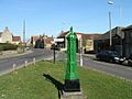
A water pump in The Ring, between the High Street and Lower Road.
-
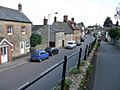
The view down Church Hill, by St Mary's Parish.
-
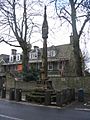
The historic Market Cross in Stalbridge.
-
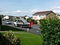
A newer housing estate on Blackmore Road, looking towards Boyle Close.
-
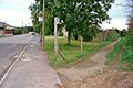
A bridleway, a path for horses and walkers, in Stalbridge.


See also
 In Spanish: Stalbridge para niños
