Steamboat Mountain (Coconino County, Arizona) facts for kids
Quick facts for kids Steamboat Mountain |
|
|---|---|

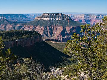
Northeast aspect, from Locust Point
|
|
| Highest point | |
| Elevation | 7,410 ft (2,260 m) |
| Prominence | 1,370 ft (420 m) |
| Isolation | 2.48 mi (3.99 km) |
| Parent peak | Powell Plateau (7,661 ft) |
| Geography | |
| Location | Grand Canyon National Park Coconino County, Arizona, US |
| Parent range | Kaibab Plateau Colorado Plateau |
| Topo map | USGS Powell Plateau |
| Type of rock | sandstone, limestone, mudstone |
Steamboat Mountain is a tall mountain in the Grand Canyon. It stands 7,410 feet (2,260 meters) high. You can find it in Coconino County, in northern Arizona, USA. This mountain is about four miles northwest of Holy Grail Temple. It is also 2.5 miles west-southwest of Timp Point on the North Rim.
A writer named George Wharton James once called Steamboat Mountain a "majestic butte." This means it's a grand, flat-topped hill with steep sides. The mountain is almost completely surrounded by two canyons, Galloway and Saddle Canyons. Steamboat Mountain rises more than 5,400 feet (1,645 meters) above the Colorado River. Its name was officially chosen in 1932.
How Steamboat Mountain Got Its Name
In 1858, an explorer named Lieutenant Joseph Ives led a trip up the Colorado River. He used a special boat called a steamboat, named Explorer. Steamboat Mountain is in an area where many places are named after early explorers of the Grand Canyon.
Steamboat Mountain is at the northern tip of a large flat area called Powell Plateau. This plateau is named after John Wesley Powell, another famous explorer. Other points on Powell Plateau are also named after explorers. These include Ives Point, Newberry Point, Dutton Point, Wheeler Point, Thompson Point, and Beale Point. All these brave pioneers are remembered at the Explorers Monument. This monument is located just south of Powell Plateau.
What Steamboat Mountain Is Made Of
Steamboat Mountain is made up of different layers of rock. The top layer is called Permian Kaibab Limestone. Below that, you can see a clear band of cream-colored rock. This is the Permian Coconino Sandstone. This sandstone layer is about 265 million years old. It formed from ancient sand dunes.
Underneath the Coconino Sandstone, there's a sloping layer called the Permian Hermit Formation. Below that is the Pennsylvanian-Permian Supai Group. Even further down, you'll find Mississippian Redwall Limestone. Then comes the Cambrian Tonto Group. Finally, at the very bottom, near the river, are the ancient Paleoproterozoic Vishnu Basement Rocks.
 | Madam C. J. Walker |
 | Janet Emerson Bashen |
 | Annie Turnbo Malone |
 | Maggie L. Walker |


