
Stony Run (Buffalo Creek tributary) facts for kids
Quick facts for kids Stony Run |
|
|---|---|

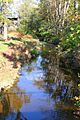
Stony Run looking downstream
|
|
| Physical characteristics | |
| Main source | valley in West Buffalo Township, Union County, Pennsylvania between 680 and 700 feet (210 and 210 m) |
| River mouth | Buffalo Creek in Buffalo Township, Union County, Pennsylvania 505 ft (154 m) 40°57′41″N 77°00′11″W / 40.96134°N 77.00309°W |
| Length | 3.3 mi (5.3 km) |
| Basin features | |
| Progression | Buffalo Creek → West Branch Susquehanna River → Susquehanna River → Chesapeake Bay |
| Basin size | 1.46 sq mi (3.8 km2) |
| Tributaries |
|
Stony Run is a small stream, or tributary, in Union County, Pennsylvania. It flows into Buffalo Creek. The stream is about 3.3 miles (5.3 kilometers) long. It flows through two areas: West Buffalo Township and Buffalo Township.
The land around Stony Run, called its watershed, covers about 1.46 square miles (3.78 square kilometers). This stream is important because it's home to many fish and tiny water creatures. However, it faces challenges from pollution, like too many nutrients, dirt, and bacteria. The water can also get too warm. Most of the land in its watershed is covered by forests or farms. Stony Run is special because it's a "High-Quality Coldwater Fishery," meaning it's a great place for fish that like cold water. It's also a "Migratory Fishery," which means fish travel through it to lay their eggs.
Contents
Where Stony Run Flows

Stony Run starts in West Buffalo Township. It flows generally east-southeast through a wide valley. This valley is also shared by another stream called Rapid Run.
After flowing for more than a mile, Stony Run enters Buffalo Township. Here, it turns to the southeast for a short distance. Then, another small stream joins it from the left side. Stony Run then turns southwest for a bit before turning back to the east-southeast. After flowing a little further, it turns southeast again. Finally, it meets and joins Buffalo Creek.
Stony Run connects with Buffalo Creek about 9.68 miles (15.58 kilometers) upstream from where Buffalo Creek ends.
Water Quality and Pollution
The water in Stony Run is affected by several types of pollution. These include nutrient pollution, which means there are too many nutrients like nitrogen and phosphorus. It also has sediment (dirt and tiny bits of rock) and E. coli bacteria. Sometimes, the water can also get too warm, which is called thermal radiation.
These pollutants can harm the plants and animals that live in the stream. For example, too much sediment can cover up the places where fish lay eggs. Too many nutrients can cause algae to grow too much, which uses up oxygen that fish need. E. coli bacteria can make the water unsafe.
Experts have studied the amount of dirt, nitrogen, and phosphorus in the stream. They are working on ways to reduce these pollutants. For instance, they are trying to lower the amount of dirt and nutrients that wash off farms and other areas into the stream.
The stream also has a lot of tiny living things called pathogens, which are germs. Most of these germs come from urban areas, but some also come from farm animals and wildlife. Scientists are working to reduce the amount of these germs in the water.
Land and Rocks Around the Stream
The land around Stony Run changes in height. Where Stony Run joins Buffalo Creek, the elevation is about 505 feet (154 meters) above sea level. Where the stream begins, its source, the elevation is higher, between 680 and 700 feet (207 and 213 meters) above sea level.
Near the start of Stony Run, there is a place called Forest Hill. Also, some very old piles of dirt and rocks, called a debris fan, can be found nearby. These were left behind from the last Pleistocene Ice Age.
Stony Run's Watershed
The watershed of Stony Run is the entire area of land where all the rain and snow eventually drain into the stream. This area covers about 1.46 square miles (3.78 square kilometers). Stony Run is located entirely within the Mifflinburg quadrangle, which is a map area used by the United States Geological Survey.
There are about 4.0 miles (6.4 kilometers) of streams within this watershed. About 1.0 mile (1.6 kilometers) of these streams flow through farm fields. The end of Stony Run is close to a town called Cowan.
Most of the land in the Stony Run watershed is covered by forests, about 61 percent. Another 32 percent of the land is used for agriculture, like growing crops or raising animals. A small part, about 3 percent, is covered by hard surfaces like roads and buildings.
None of the farm land in this watershed is on very steep hills. This is good because steep hills can cause more dirt to wash into the stream. There are also no unpaved roads in the watershed, which helps keep dirt out of the water.
The Stony Run watershed makes up about 1 percent of the larger Buffalo Creek drainage basin.
History of Stony Run
Stony Run was officially added to the Geographic Names Information System on August 2, 1979. This system keeps track of names and locations of places in the United States. Its special ID number is 1188794.
Long ago, in 1770, a piece of land called the John Umstead tract was surveyed along Stony Run. This survey was done by a person named Thomas Sutherland.
In a report from 2008, the Stony Run watershed was listed as one of the top areas in the Buffalo Creek region that needed help with restoration. This means people wanted to work on making the stream and its surrounding land healthier.
Animals and Plants
Stony Run is a very important place for fish and other water creatures. It is called a "High-Quality Coldwater Fishery" and a "Migratory Fishery." This means it's a great place for fish that need cold, clean water, and fish that travel through it to lay their eggs.
The stream also has a "healthy" population of benthic macroinvertebrates. These are tiny creatures without backbones, like insects and worms, that live on the bottom of the stream. A healthy population of these tiny creatures usually means the stream's water quality is good.
Along the sides of the streams in the watershed, there are about 0.2 miles (0.3 kilometers) of riparian buffers. These are areas of plants and trees that grow along the stream banks. They are very important because they help filter out pollution, keep the water cool, and provide homes for wildlife.
Images for kids
-
Stony Run looking downstream
-
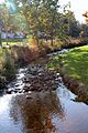
Stony Run looking upstream
