
Switzerland County, Indiana facts for kids
Quick facts for kids
Switzerland County
|
|
|---|---|
.jpg)
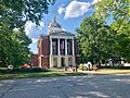
Switzerland County Courthouse in Vevay
|
|

Location within the U.S. state of Indiana
|
|
 Indiana's location within the U.S. |
|
| Country | |
| State | |
| Founded | 1814 |
| Named for | Switzerland |
| Seat | Vevay |
| Largest town | Vevay |
| Area | |
| • Total | 223.44 sq mi (578.7 km2) |
| • Land | 220.63 sq mi (571.4 km2) |
| • Water | 2.81 sq mi (7.3 km2) 1.26%% |
| Population
(2020)
|
|
| • Total | 9,737 |
| • Estimate
(2023)
|
10,019 |
| • Density | 43.578/sq mi (16.8254/km2) |
| Time zone | UTC−5 (Eastern) |
| • Summer (DST) | UTC−4 (EDT) |
| Congressional district | 9th |
| Indiana county number 78 | |
Switzerland County is a cool place in the southeast corner of Indiana, a state in the United States. It's known for its beautiful rolling hills and its history with the Ohio River. In 2020, about 9,737 people lived here. The main town and county seat is Vevay.
Contents
A Look Back: Switzerland County's History
How Indiana Became a State
Long ago, in 1787, the United States created a huge area called the Northwest Territory. This land included what is now Indiana. Later, in 1800, a part of this territory became the Indiana Territory. Thomas Jefferson, who was president, chose William Henry Harrison to be its first governor. The capital was in a town called Vincennes. Over time, parts of the Indiana Territory became other states, and Indiana got its current shape. By December 1816, Indiana officially joined the United States as a state!
Land and Early Settlers
Before settlers arrived, the land in Indiana belonged to Native American tribes. Starting in 1794, the United States gained control of these lands through different ways, like treaties and purchases. For example, the US got land from Native Americans in the 1809 Treaty of Fort Wayne and the 1818 Treaty of St. Mary's. These treaties opened up the southeastern part of Indiana for new settlers.
People started moving into this area, including what is now Switzerland County, around 1795. By 1814, enough people lived there to create a new county. So, on October 1, 1814, Switzerland County was officially formed from parts of other counties.
Choosing the County Seat
When Switzerland County was created, several small settlements wanted to be the county seat, which is like the main town where the government offices are. These towns were Vevay, Little York (now Florence), Troy (now Patriot), and Center Square. Even though Center Square was in the middle of the county, Vevay won the vote and became the county seat!
Early Families and River Travel
Some of the first settlers in Switzerland County came from Switzerland. One of the earliest was Heathcoat Pickett in 1795. Other families like the Dufours, Dickasons, Cottons, and Rayls also arrived around 1798.
Heathcoat Pickett was very clever! He built the area's first flatboats. He would load them with goods to sell, float them all the way down the Ohio River to New Orleans, sell everything, and then walk all the way back to Switzerland County! He made this long trip 20 times.
In 1811, people in the county saw the first steamboat on the Ohio River. This was a big deal! Steamboats quickly made the river a busy highway for trade and travel. However, even though other parts of Indiana got many railroad tracks in the 1800s, Switzerland County did not. This made it harder for the county to grow after steamboat travel became less popular.
Switzerland County was also famous for growing grapes to make wine. Because of this, it was sometimes called "The Rhineland of America," like the famous wine region in Germany.
Exploring Switzerland County's Geography
Switzerland County is located at the very southeastern tip of Indiana. The Ohio River forms its southeastern border, and on the other side of the river is the state of Kentucky.
The county has many rolling hills that were once covered in forests. The flatter areas are now used for farms or towns, but many of the valleys and waterways are still wooded. The highest point in the county is a hill in the northwest, which is about 981 feet (299 meters) above sea level.
According to the 2010 census, Switzerland County covers about 223.44 square miles. Most of this (about 220.63 square miles) is land, and a small part (about 2.81 square miles) is water.
Neighboring Counties
Switzerland County shares its borders with these other counties:
- Ohio County - to the north
- Boone County, Kentucky - to the northeast
- Gallatin County, Kentucky - to the east
- Carroll County, Kentucky - to the south
- Jefferson County - to the west
- Ripley County - to the northwest
Towns in Switzerland County
Switzerland County has two official towns:
There are also many smaller, unincorporated communities:
- Aaron
- Allensville
- Antioch
- Avonburg
- Bennington
- Braytown
- Center Square
- East Enterprise
- Fairview
- Florence
- Five Points
- Gurley Corner
- Jacksonville
- Lamb
- Long Run
- Markland
- Moorefield
- Mount Sterling
- Pleasant
- Quercus Grove
- Searcy Crossroads
Local Government Areas: Townships
Counties in Indiana are divided into smaller areas called townships. Switzerland County has six townships:
- Cotton
- Craig
- Jefferson
- Pleasant
- Posey
- York
Major Roads in the County
These are some of the main highways that run through Switzerland County:
 Indiana State Road 56
 Indiana State Road 101
 Indiana State Road 129
 Indiana State Road 156
 Indiana State Road 250
Climate and Weather in Switzerland County
| Weather chart for Vevay, Indiana | |||||||||||||||||||||||||||||||||||||||||||||||
|---|---|---|---|---|---|---|---|---|---|---|---|---|---|---|---|---|---|---|---|---|---|---|---|---|---|---|---|---|---|---|---|---|---|---|---|---|---|---|---|---|---|---|---|---|---|---|---|
| J | F | M | A | M | J | J | A | S | O | N | D | ||||||||||||||||||||||||||||||||||||
|
3.2
40
23
|
3
46
26
|
4.1
56
35
|
4.2
67
43
|
4.7
77
53
|
4.6
85
62
|
3.9
88
67
|
4
86
65
|
3.1
80
58
|
3.1
68
46
|
3.7
55
37
|
3.7
44
28
|
||||||||||||||||||||||||||||||||||||
| temperatures in °F precipitation totals in inches source: The Weather Channel |
|||||||||||||||||||||||||||||||||||||||||||||||
|
Metric conversion
|
|||||||||||||||||||||||||||||||||||||||||||||||
The weather in Vevay, the county seat, changes throughout the year. In January, the average low temperature is about 23°F (around -5°C). In July, the average high temperature is about 88°F (around 31°C).
However, temperatures can go to extremes! The coldest temperature ever recorded in January 1977 was -24°F (-31°C). The hottest temperature ever recorded in July 1999 was 106°F (41°C).
The amount of rain also changes. February usually gets the least rain, about 3.00 inches (7.6 cm). May tends to be the wettest month, with about 4.72 inches (12.0 cm) of rain.
Who Lives in Switzerland County? Demographics
| Historical population | |||
|---|---|---|---|
| Census | Pop. | %± | |
| 1820 | 3,934 | — | |
| 1830 | 7,028 | 78.6% | |
| 1840 | 9,920 | 41.1% | |
| 1850 | 12,932 | 30.4% | |
| 1860 | 12,698 | −1.8% | |
| 1870 | 12,134 | −4.4% | |
| 1880 | 13,336 | 9.9% | |
| 1890 | 12,514 | −6.2% | |
| 1900 | 11,840 | −5.4% | |
| 1910 | 9,914 | −16.3% | |
| 1920 | 9,311 | −6.1% | |
| 1930 | 8,432 | −9.4% | |
| 1940 | 8,167 | −3.1% | |
| 1950 | 7,599 | −7.0% | |
| 1960 | 7,092 | −6.7% | |
| 1970 | 6,306 | −11.1% | |
| 1980 | 7,153 | 13.4% | |
| 1990 | 7,738 | 8.2% | |
| 2000 | 9,065 | 17.1% | |
| 2010 | 10,613 | 17.1% | |
| 2020 | 9,737 | −8.3% | |
| 2023 (est.) | 10,019 | −5.6% | |
| US Decennial Census 1790-1960 1900-1990 1990-2000 2010-2013 |
|||
Population in 2010
In 2010, the county had 10,613 people living in 4,034 households. About 2,847 of these were families. The population density was about 48.1 people per square mile. There were also 4,969 housing units, like houses and apartments.
Most people in the county (97.8%) were white. A small number were Black or African American (0.3%), Asian (0.2%), or American Indian (0.2%). About 1.4% of the population was of Hispanic or Latino background.
Many families in Switzerland County had children under 18 living with them (33.5%). Most households were married couples living together (54.2%). The average age of people in the county was 39.1 years old.
The average income for a household in the county was $47,697. For families, it was $51,769. About 14.4% of all people in the county lived below the poverty line. This included 19.2% of those under 18 and 7.5% of those aged 65 or older.
Images for kids
-
Switzerland County Courthouse in Vevay
See also
 In Spanish: Condado de Switzerland para niños
