
Thermopolis, Wyoming facts for kids
Quick facts for kids
Thermopolis, Wyoming
|
|
|---|---|

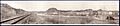
Thermopolis viewed from Roundtop Mountain
|
|
| Nickname(s):
"Thermop" "T-Town"
|
|
| Motto(s):
"A Past To Behold, A Future To Uphold"
|
|

Location of Thermopolis in Hot Springs County, Wyoming.
|
|

Thermopolis, Wyoming
Location in Wyoming

Thermopolis, Wyoming
Location in the United States
|
|
| Country | United States |
| State | Wyoming |
| County | Hot Springs |
| Named for | Greek for "Hot City", named for the county's natural hot springs |
| Area | |
| • Total | 2.47 sq mi (6.39 km2) |
| • Land | 2.39 sq mi (6.18 km2) |
| • Water | 0.08 sq mi (0.21 km2) |
| Elevation | 4,331 ft (1,320 m) |
| Population
(2020)
|
|
| • Total | 2,725 |
| • Density | 1,157.94/sq mi (447.11/km2) |
| Time zone | UTC−7 (Mountain (MST)) |
| • Summer (DST) | UTC−6 (MDT) |
| ZIP code |
82443
|
| Area code(s) | 307 |
| FIPS code | 56-76515 |
Thermopolis is a town in Wyoming, United States. It is the main town and county seat of Hot Springs County. In 2020, about 2,725 people lived there.
The name "Thermopolis" comes from Greek words meaning "hot city." This is because the town has many natural hot springs. These springs have mineral-rich water heated deep underground.
One of the most famous spots is "The Big Spring" in Hot Springs State Park. It is said to be the world's largest mineral hot spring. You can visit these springs for free. This was part of a special agreement made in 1896 with the Shoshone and Arapaho Native American tribes.
In 1993, dinosaur fossils were found nearby. This led to the creation of the Wyoming Dinosaur Center, a museum where you can see these amazing finds.
Contents
Exploring Thermopolis's Location
Thermopolis is located in a unique area of Wyoming. It sits near the northern end of the Wind River Canyon. This is where the Wind River changes its name to the Bighorn River. This change happens without two rivers joining, which is quite rare! People call this spot the "Wedding of the Waters."
Mountains and Natural Features Around Thermopolis
Mountains surround Thermopolis. To the northeast are the Big Horn Mountains. The Bridger Mountains are to the southeast. The Owl Creek Mountains are southwest, and the Absaroka Range is northwest. Thermopolis is the southernmost town in the Big Horn Basin.
Just north of town is Roundtop Mountain. It looks a bit like a volcano and is the highest point right around Thermopolis, standing about 6,000 feet tall.
About 17 miles south of Thermopolis is Boysen Reservoir. This large lake is home to many kinds of fish, like rainbow trout, walleye, and perch.
The town covers about 2.47 square miles. Most of this area is land, with a small part being water.
Thermopolis Weather and Climate
Thermopolis has a cool, semi-arid climate. This means it's generally dry, but not a desert. The hottest temperature ever recorded in Thermopolis was 107°F on July 25, 1929. The coldest was -44°F on January 16, 1930.
| Climate data for Thermopolis, Wyoming, 1991–2020 normals, extremes 1899–present | |||||||||||||
|---|---|---|---|---|---|---|---|---|---|---|---|---|---|
| Month | Jan | Feb | Mar | Apr | May | Jun | Jul | Aug | Sep | Oct | Nov | Dec | Year |
| Record high °F (°C) | 67 (19) |
70 (21) |
80 (27) |
89 (32) |
98 (37) |
105 (41) |
107 (42) |
106 (41) |
102 (39) |
92 (33) |
77 (25) |
78 (26) |
107 (42) |
| Mean maximum °F (°C) | 53.9 (12.2) |
57.4 (14.1) |
70.3 (21.3) |
79.6 (26.4) |
87.8 (31.0) |
95.9 (35.5) |
100.6 (38.1) |
98.6 (37.0) |
93.9 (34.4) |
82.6 (28.1) |
67.6 (19.8) |
55.9 (13.3) |
101.1 (38.4) |
| Mean daily maximum °F (°C) | 37.3 (2.9) |
41.6 (5.3) |
54.0 (12.2) |
61.9 (16.6) |
71.4 (21.9) |
82.9 (28.3) |
91.8 (33.2) |
89.8 (32.1) |
79.7 (26.5) |
64.5 (18.1) |
48.6 (9.2) |
37.5 (3.1) |
63.4 (17.5) |
| Daily mean °F (°C) | 24.4 (−4.2) |
28.6 (−1.9) |
39.8 (4.3) |
47.6 (8.7) |
57.0 (13.9) |
66.8 (19.3) |
74.5 (23.6) |
72.4 (22.4) |
62.7 (17.1) |
49.1 (9.5) |
35.1 (1.7) |
24.9 (−3.9) |
48.6 (9.2) |
| Mean daily minimum °F (°C) | 11.5 (−11.4) |
15.6 (−9.1) |
25.6 (−3.6) |
33.4 (0.8) |
42.5 (5.8) |
50.6 (10.3) |
57.1 (13.9) |
55.0 (12.8) |
45.7 (7.6) |
33.8 (1.0) |
21.7 (−5.7) |
12.3 (−10.9) |
33.7 (1.0) |
| Mean minimum °F (°C) | −10.9 (−23.8) |
−6.7 (−21.5) |
7.2 (−13.8) |
18.9 (−7.3) |
29.5 (−1.4) |
39.4 (4.1) |
48.5 (9.2) |
45.1 (7.3) |
32.8 (0.4) |
16.5 (−8.6) |
0.6 (−17.4) |
−9.1 (−22.8) |
−17.0 (−27.2) |
| Record low °F (°C) | −44 (−42) |
−42 (−41) |
−28 (−33) |
−6 (−21) |
12 (−11) |
24 (−4) |
34 (1) |
23 (−5) |
7 (−14) |
−11 (−24) |
−28 (−33) |
−38 (−39) |
−44 (−42) |
| Average precipitation inches (mm) | 0.39 (9.9) |
0.44 (11) |
0.85 (22) |
1.63 (41) |
2.53 (64) |
1.31 (33) |
0.76 (19) |
0.50 (13) |
1.21 (31) |
1.27 (32) |
0.60 (15) |
0.46 (12) |
11.95 (302.9) |
| Average snowfall inches (cm) | 5.4 (14) |
4.9 (12) |
2.3 (5.8) |
2.2 (5.6) |
0.2 (0.51) |
0.0 (0.0) |
0.0 (0.0) |
0.0 (0.0) |
0.3 (0.76) |
2.1 (5.3) |
5.5 (14) |
4.5 (11) |
27.4 (68.97) |
| Average precipitation days (≥ 0.01 in) | 3.0 | 3.6 | 4.1 | 6.5 | 7.8 | 7.2 | 5.1 | 4.4 | 5.2 | 4.9 | 3.9 | 3.2 | 58.9 |
| Average snowy days (≥ 0.1 in) | 2.6 | 2.8 | 1.6 | 0.9 | 0.1 | 0.0 | 0.0 | 0.0 | 0.1 | 0.7 | 2.0 | 2.5 | 13.3 |
| Source 1: NOAA | |||||||||||||
| Source 2: National Weather Service | |||||||||||||
Who Lives in Thermopolis?
| Historical population | |||
|---|---|---|---|
| Census | Pop. | %± | |
| 1900 | 299 | — | |
| 1910 | 1,524 | 409.7% | |
| 1920 | 2,005 | 31.6% | |
| 1930 | 2,129 | 6.2% | |
| 1940 | 2,422 | 13.8% | |
| 1950 | 2,870 | 18.5% | |
| 1960 | 3,955 | 37.8% | |
| 1970 | 3,063 | −22.6% | |
| 1980 | 3,852 | 25.8% | |
| 1990 | 3,247 | −15.7% | |
| 2000 | 3,172 | −2.3% | |
| 2010 | 3,009 | −5.1% | |
| 2020 | 2,725 | −9.4% | |
| 2023 (est.) | 2,742 | −8.9% | |
| U.S. Decennial Census | |||
In 2010, Thermopolis had 3,009 people living in 1,389 households. About 24% of these households had children under 18. Many households were married couples, and some were single-parent families.
The average age in Thermopolis was 47 years old. About 20% of the people were under 18. About 22% were 65 or older. The town had slightly more females than males.
What Drives Thermopolis's Economy?
Tourism is very important to Thermopolis because of Hot Springs State Park.
Fun Things to Do in Thermopolis
- Hot Springs State Park: This park is home to a state-maintained herd of American Bison. Inside the park, you can find two hot mineral water places with water slides and other fun attractions: the Teepee Pools and Star Plunge.
- Downtown Thermopolis Historic District: This area has old buildings and a unique feel.
- Hot Springs County Museum and Cultural Center: Here, you can see items from early settlers from the late 1800s and early 1900s. The museum also plans to focus on Tim McCoy, a famous actor from old cowboy movies who lived in the area.
- Wyoming Dinosaur Center: Located nearby in East Thermopolis, this center is a non-profit organization. They dig for dinosaur fossils in the area. You can visit their museum, gift shop, and even join a dig tour to help find fossils!
- Hot Spot Shootout Basketball Tournament: Every May since 1993, thousands of basketball players come to Thermopolis for this big tournament. Several blocks of the city are closed off, and many temporary basketball courts are set up on the streets.
- Solar Eclipse: On August 21, 2017, Thermopolis was a great place to see a total eclipse of the sun.
Learning in Thermopolis
Public schools in Thermopolis are part of Hot Springs County School District Number 1. This is the only school district in the county.
The schools include Ralph Witters Elementary School, Thermopolis Middle School, and Hot Springs County High School. All of the sports teams are called the Thermopolis Bobcats, and their colors are purple and gold.
News and Media in Thermopolis
The Thermopolis Independent Record is a weekly newspaper that has been published since 1901. You can also listen to radio stations like Classic Country station KDNO and classical music station KUWT.
Getting Around Thermopolis
Major Roads
 U.S. Route 20: This highway runs north-south through the town.
 WYO 120: This road goes northwest towards the towns of Meeteetse and Cody.
 WYO 789: This highway also runs north-south through the city, sharing its path with U.S. 20 for a bit.
Bus Service
You can find intercity bus service to Thermopolis provided by Express Arrow.
Airport
The Hot Springs County–Thermopolis Municipal Airport serves Thermopolis for small planes and general aviation.
Famous People from Thermopolis
Many notable people have connections to Thermopolis:
- Wyatt Agar: A Republican politician who served in the Wyoming Senate.
- Don Bracken: An American football punter who played for the Green Bay Packers and Los Angeles Rams.
- Clayton Danks: A famous cowboy who modeled for the Wyoming cowboy symbol.
- Mike Enzi: A United States Senator from Wyoming.
- Dave Freudenthal: A former governor of Wyoming.
- Steve Freudenthal: A Democratic politician who served as the Attorney General of Wyoming.
- W. Michael Gear and Kathleen O'Neal Gear: Both are well-known writers and archaeologists.
- Morris H. Hansen: A statistician born in Thermopolis.
- Dora McGrath: The first woman elected to the Wyoming State Senate.
- Barton R. Voigt: A former Chief Justice of the Wyoming Supreme Court.
- John Winter: A Republican politician who serves in the Wyoming House of Representatives.
- Nathan Winters: A former Republican politician who served in the Wyoming House of Representatives.
Images for kids
-
Thermopolis, 1918
See also
 In Spanish: Thermopolis (Wyoming) para niños
