Thompsonville, Connecticut facts for kids
Quick facts for kids
Thompsonville, Connecticut
|
|
|---|---|

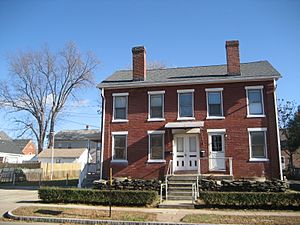
Brick houses in Thompsonville
|
|
| Country | United States |
| State | Connecticut |
| County | Hartford |
| Town | Enfield |
| Area | |
| • Total | 2.34 sq mi (6.06 km2) |
| • Land | 2.03 sq mi (5.27 km2) |
| • Water | 0.31 sq mi (0.79 km2) |
| Elevation | 115 ft (35 m) |
| Population
(2010)
|
|
| • Total | 8,577 |
| • Density | 4,214/sq mi (1,627.1/km2) |
| Time zone | UTC-5 (Eastern) |
| • Summer (DST) | UTC-4 (Eastern) |
| ZIP code |
06082
|
| Area code(s) | 860 |
| FIPS code | 09-75940 |
| GNIS feature ID | 2377873 |
Thompsonville is a community located in the town of Enfield, in Hartford County, Connecticut, USA. It is known as a census-designated place (CDP), which means it's a special area defined for collecting population data. In 2010, about 8,577 people lived there.
History of Thompsonville
Thompsonville started in the 1800s as a place where carpets were made. A man named Orrin Thompson built a dam across Freshwater Brook in 1828. The very next year, in 1829, he opened the first carpet factory.
His first factory was called "White Mill." It hired skilled weavers who came all the way from Scotland. At first, they made simple, flat carpets. But over time, they started making more fancy and expensive types of carpets. By 1846, the factory had 230 looms working to make carpets!
People continued to make carpets in Thompsonville until 1971. After that, most carpet making moved to factories in the southern parts of the United States.
Geography of Thompsonville
Thompsonville covers an area of about 6.1 square kilometers (2.3 square miles). Most of this area, about 5.3 square kilometers (2.0 square miles), is land. The rest, about 0.8 square kilometers (0.3 square miles), is water.
The community is located on the east side of the Connecticut River. Interstate 91, a major highway, runs along its eastern border. U.S. Route 5, also known as Enfield Street, is the main road that goes through Thompsonville. This road goes north to Longmeadow, Massachusetts and Springfield. It also goes south through East and South Windsor to East Hartford.
Another road, Connecticut Route 190, crosses Route 5. If you go west on Route 190, you cross the Connecticut River into Suffield. If you go east, you reach Hazardville.
People of Thompsonville
In 2000, there were 8,125 people living in Thompsonville. These people lived in 3,442 households. About 29.5% of these households had children under 18 years old living with them.
The people living in Thompsonville had different ages. About 25.5% were under 18 years old. About 34.0% were between 25 and 44 years old. And about 15.7% were 65 years old or older. The average age of people in Thompsonville was 35 years.
See also
 In Spanish: Thompsonville (Connecticut) para niños
 | Mary Eliza Mahoney |
 | Susie King Taylor |
 | Ida Gray |
 | Eliza Ann Grier |


