
Timgad facts for kids
|
تيمقاد
|
|
.jpg)
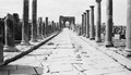
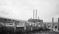
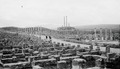
The Roman ruins of Timgad
|
|

Location in Algeria
|
|
| Alternative name |
|
|---|---|
| Location | Batna Province, Algeria |
| Region | Maghreb |
| Coordinates | 35°29′03″N 6°28′07″E / 35.48417°N 6.46861°E |
| Type | Settlement |
| History | |
| Founded | 100 CE |
| Abandoned | 7th century |
| Periods | Roman Empire |
| Official name | Timgad |
| Type | Cultural |
| Criteria | ii, iii, iv |
| Designated | 1982 (6th session) |
| Reference no. | 194 |
| Region | Arab States |
Timgad (Arabic: تيمقاد, romanized: Tīmgād) was an ancient Roman city located in the Aurès Mountains of Algeria. It was founded by the Roman Emperor Trajan around the year 100 CE. The city's full name was Colonia Marciana Ulpia Traiana Thamugadi. Emperor Trajan named it to honor his family members.
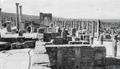
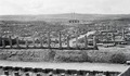
Today, Timgad's ruins are found in modern-day Algeria. They are about 35 kilometers (22 miles) east of the city of Batna. The site is famous for showing one of the best examples of a grid plan used in Roman town planning. Because of its importance, Timgad was named a World Heritage Site by UNESCO in 1982.
Contents
What's in a Name?
The city's full Roman name was Marciana Traiana Thamugadi. The first part, Marciana Traiana, comes from its founder, Emperor Trajan, and his sister Marciana.
The second part, Thamugadi, is not Latin. It comes from the Berber language. Thamugadi is the Berber name for the area where the city was built. It means "peak" or "summit."
Timgad's Story: From Roman City to Ruins
Founding a Roman Military Town
The city of Timgad was started as a military settlement by Emperor Trajan in 100 CE. Its main purpose was to be a strong Roman base against the Berbers living in the nearby Aures Mountains.
Many of the first people to live in Timgad were Roman soldiers who had finished their service. Even though most of them had never seen Rome, the city focused on Roman culture and identity.
Peaceful Times and Christianity
For the first few hundred years, Timgad was a peaceful place. It became an important center for Christian activities starting in the 3rd century. By the 4th century, it was a key city for a Christian group called the Donatists.
A famous Bishop named Optat from Timgad became a leader for the Donatist movement. After him, the city had two bishops, one Donatist and one Catholic.
Decline and Rediscovery
In the 5th century, the city was attacked by the Vandals. After this, Timgad started to decline. It was destroyed by Berber tribes from the Aurès Mountains at the end of the 5th century.
In 539 CE, during wars with the Moors, the Byzantine general Solomon took back and rebuilt parts of the city. He made it part of a defense line against the Moors. However, the early Muslim conquests led to Timgad being completely abandoned by the 8th century.
The ruins of Timgad were rediscovered by a Scottish explorer named James Bruce. He visited the site on December 12, 1765. He was likely the first European to see the ruins in centuries. Bruce described Timgad as "a small town, but full of elegant buildings."
In 1790, he wrote about his findings in a book called Travels to Discover the Source of the Nile. At first, people in Great Britain were doubtful of his stories. But in 1875, Robert Lambert Playfair, a British consul in Algeria, visited the site after reading Bruce's book.
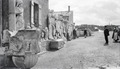
Playfair described Timgad in more detail in his 1877 book, Travels in the Footsteps of Bruce in Algeria and Tunis. He noted that the hills around Timgad were "covered with countless numbers of the most interesting mega-lithic remains." French colonists took control of the site in 1881 and began to dig up and preserve the ruins until 1960.

Exploring the City's Layout

Timgad was built at a place where six roads met. The city had walls, but they were not for defense.
The city was first planned for about 15,000 people. But it quickly grew bigger than expected. New parts of the city were built outside the original grid in a less organized way.
When Timgad was founded, the area around it was very good for farming. It was located about 1,000 meters (3,280 feet) above sea level.
Roman Streets and Arch
The original Roman grid plan is very clear. It is marked by the decumanus maximus (the main east-west street) and the cardo (the main north-south street). These streets were lined with columns, some of which have been rebuilt.
The cardo does not go all the way through the city. Instead, it ends at a forum, which was the city's main public square. This is where it met the decumanus.
At the west end of the decumanus stands a 12-meter (39-foot) tall triumphal arch. It is called the Arch of Trajan. This arch was partly restored in 1900. It is mostly made of sandstone and has three arches, with the middle one being 11 feet (3.4 meters) wide.
Key Buildings
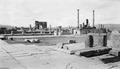
Timgad also has a large theater that could seat 3,500 people. It is still in good condition and is sometimes used for shows today. Other important buildings include four public baths (thermae), a library, and a large public building called a basilica.
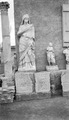
The Capitoline Temple was dedicated to the Roman god Jupiter. It was about the same size as the Pantheon in Rome. Near the capitol, there is a square church with a round apse that dates back to the 7th century CE. One of the city's holy places featured pictures of the goddess Africa. South of the city, there is a large Byzantine citadel that was built later in the city's history.
The Ancient Library of Timgad

The Library at Timgad was a gift to the Roman people. A man named Julius Quintianus Flavius Rogatianus paid 400,000 sesterces to build it. We don't know much more about him, so the exact date the library was built is not certain. Experts think it was built in the late 3rd or possibly the 4th century.
The library building was a rectangle, about 25 meters (81 feet) long and 23.5 meters (77 feet) wide. It had a large semi-circular room with two smaller rectangular rooms on each side. In front of it was a U-shaped area with columns around an open courtyard.
The main hall was vaulted and likely used as a reading room, a place to store scrolls, and maybe even a lecture room. Along the walls, there were long, narrow spaces where wooden shelves would have held the scrolls. These shelves probably had sides, backs, and doors, similar to those found in the library at Ephesus.
It's also possible that there were freestanding bookcases in the middle of the room and reading desks. The building itself might not be super fancy, but finding this library is very important. It shows that Timgad had a well-developed library system. This means the city had a high level of learning and culture. We don't know how many scrolls the library held, but it's estimated it could have stored about 3,000.
World Heritage Site Status
Timgad was recognized as a World Heritage Site by UNESCO in 1982. This means it is considered a very important place for all of humanity to protect and preserve.
Images for kids

See Also
- Djémila
- Jerash
- Lambaesis
- Colonia (Roman)
- List of cultural assets of Algeria
