Transportation in Cincinnati facts for kids
Getting around Cincinnati is a mix of different ways to travel! People use sidewalks, roads, public buses, bike paths, and even airports. Most people in Cincinnati use cars to get where they need to go. Public transportation and bikes are used less often.
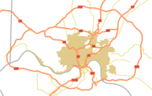
Cincinnati has three big interstate highways: I-71, I-74, and I-75. These highways cut through the city. There's also a big highway loop, called a beltway, that goes around the city a few miles out.
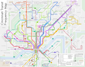
Two main bus systems serve the area, one on each side of the Ohio River. The SORTA system is in Ohio and is much bigger. The TANK system is in Kentucky. Most bus lines in Cincinnati lead to Downtown Cincinnati. Because Cincinnati has many hills, its streets aren't always in a neat grid like in some other cities.
Contents
Roads in Cincinnati
Cincinnati's roads include three major interstate highways, one interstate bypass, one interstate spur, and six U.S. highways.
Interstate Highways
Cincinnati is connected by three main interstate highways, one beltway (a loop around the city), and one spur (a shorter highway branching off a main one).
- Interstate 71: This highway splits from Interstate 75 near the Brent Spence Bridge. It goes east through an area called Fort Washington Way. It connects with Interstate 471 and then heads northeast. It also meets up with SR 562 and SR 126.
- Interstate 74: This highway starts at Interstate 75 west of downtown and goes towards Indiana. Its main connection is with Interstate 275.
- Interstate 75: This highway runs north and south through the Mill Creek valley. It comes from Kentucky over the Brent Spence Bridge, sharing lanes with Interstate 71. I-71 then splits off to the east. I-75 also connects with Interstate 74, SR 562, and SR 126.
- Interstate 275: This is the big outer-belt highway that circles the entire metropolitan area. It's one of the longest loop highways in the country! It connects with all the major interstate highways that spread out from the city.
- Interstate 471: This is a shorter highway that starts in downtown Cincinnati and goes south into Kentucky. It ends where it meets Interstate 275 and US 27.
Important Local Expressways
Besides the interstates, Cincinnati has several important local expressways. These include the Mill Creek Expressway (which is part of Interstate 75), Fort Washington Way (part of Interstate 71), the Ronald Reagan Cross County Highway, the Norwood Lateral Expressway, Columbia Parkway, and the Sixth Street Expressway.
The downtown area also has a system of elevated roads called viaducts, like the Western Hills Viaduct and the Ida Street Viaduct.
U.S. Highways
Several U.S. highways also pass through Cincinnati:
- US 25 (only on the Clay Wade Bailey Bridge in Ohio)
- US 27
- US 42
- US 52
- US 127
- US 22
- US 50 (includes Columbia Parkway and Sixth Street Expressway)
Ohio State Routes
Here are some of the state routes in Cincinnati:
- SR 3 (Montgomery Rd.)
- SR 4 (Paddock Rd.)
- SR 32 (goes east from Cincinnati across southern Ohio)
- SR 125 (Beechmont Avenue/Ohio Pike)
- SR 126 (Ronald Reagan Cross County Highway)
- SR 264 (Glenway Ave.)
- SR 561
- SR 562 (Norwood Lateral)
Mile Road System
Some roads in Cincinnati and nearby towns are named based on how far they are from the mouth of the Little Miami River. For example, Two Mile Road is about two miles away, Four Mile Road is about four miles away, and so on. Other roads in this system include Five Mile Road, Eight Mile Road, Nine Mile Road, and Ten Mile Road. Most of these roads start at US 52.
Biking in Cincinnati
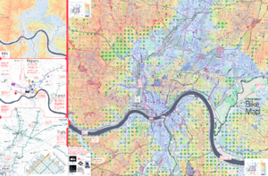
Red Bike is a public bicycle-sharing system that started in Cincinnati in 2014. It lets people rent bikes for short trips. The University of Cincinnati also has its own smaller bike-share program.
Public Transportation
Cincinnati has public transportation mainly through buses. These buses are run by the Southwest Ohio Regional Transit Authority (SORTA) in Ohio, the Transit Authority of Northern Kentucky (TANK) in Kentucky, and the Clermont Transportation Connection.
Buses
Most bus lines, including those from TANK, are focused on Downtown Cincinnati. This means many people need to transfer buses downtown to get to different parts of the city. SORTA is much larger than TANK, with more bus lines and more passengers each day.
SORTA gets most of its money from the City of Cincinnati. This means the best bus service is usually within the city limits. If you travel outside the city, it's considered "Zone 2" and costs a bit more.
SORTA and TANK mainly use 40-foot diesel buses. Some lines use longer buses or hybrid buses. Smaller minibuses are used for special services for people with disabilities.
Streetcars
Cincinnati has one streetcar line called the Connector. It runs in a loop for about 3.6 miles, connecting The Banks, Downtown, and Findlay Market in Over-the-Rhine. It opened in 2016. There are ideas to extend the streetcar to the Uptown area, where the University of Cincinnati, hospitals, and the Cincinnati Zoo are located.
Electric streetcars first started running in Cincinnati in 1889. At its busiest, the streetcar system had 222 miles of track and carried over 100 million passengers every year! But as cars became more popular and affordable, fewer people rode streetcars. The system closed in 1951.
Public Steps
The Steps of Cincinnati are a unique way to get around this hilly city. There are about 400 public stairways that connect neighborhoods on different levels of the hills. People use them to get around and also for exercise!
Intercity Travel

For longer trips, you can take a train or a bus.
- Amtrak's Cardinal train goes to cities like Chicago and Indianapolis to the west, and Washington, D.C., Philadelphia, and New York City to the east. It runs three times a week in each direction. The train station is at Cincinnati Union Terminal.
- Greyhound buses operate a terminal in Arlington Heights. They offer trips to many nearby cities and connections across the country. Other bus companies like GO Bus, Barron's Bus, and Megabus also serve Cincinnati.
Abandoned Subway
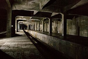
Cincinnati has an incomplete subway system that was never finished! Construction stopped in 1924 because the cost of building it doubled after World War I, and there wasn't enough money to complete the project.
There have been ideas to use these subway tunnels for a light rail system, but plans to get money for these projects haven't passed. Today, the subway tunnels are used for fiber optic cables and water lines. They are sealed off from the public.
Bridges in Cincinnati
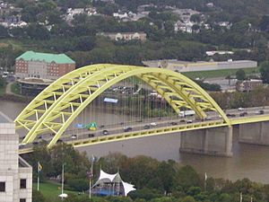
Cincinnati has many bridges that cross the Ohio River. There's also the Anderson Ferry, which has been taking people across the river since 1817!
Here are some of Cincinnati's major bridges:
- The Newport Southbank Bridge: Also known as the "Purple People Bridge" because it's purple and only for people walking or biking.
- The John A. Roebling Suspension Bridge: Opened in 1866, this bridge was a test model for the famous Brooklyn Bridge. Both were designed by John A. Roebling.
- The Daniel Carter Beard Bridge: Often called the "Big Mac" bridge because its yellow arches look like the McDonald's logo. It carries I-471 and connects Cincinnati to Newport, Kentucky.
- The Brent Spence Bridge: This is a double-decker bridge that carries I-71/75, connecting Cincinnati with Covington, Kentucky.
- The Clay Wade Bailey Bridge
- The Taylor-Southgate Bridge
- The Combs-Hehl Bridge: Part of the I-275 loop, it's often called "The 275 Bridge."
Airports
Cincinnati/Northern Kentucky International Airport (IATA: CVG) is the main international airport for the Cincinnati area. It's located across the river in Hebron, Kentucky. The airport code CVG stands for Covington, which was the closest big city when the airport was built. Even though it serves Cincinnati, it's actually in Kentucky!
CVG is an important hub for Allegiant Air and a huge cargo center for DHL Express. It's one of the busiest airports in the world for cargo.
Cincinnati also has other smaller airports:
- Lunken Airport: A city airport used for smaller business jets and private planes.
- Butler County Regional Airport: Located between Fairfield and Hamilton, it has a large capacity for private aircraft.
- Cincinnati West Airport: A smaller airport in Harrison, Ohio.
These airports, along with Dayton International Airport (about 78 miles north) and John Glenn Columbus International Airport (about 128 miles northeast), form an important network for travel in the region.
Commerce and Transportation Costs
According to Forbes Magazine, people in Cincinnati spend about 20% of their income on transportation. This makes it one of the more expensive cities for commuting in the United States.
Cincinnati is also a hub for freight railroads. CSX Transportation and Norfolk Southern operate large railroad yards here, moving goods across the country.
 | Aurelia Browder |
 | Nannie Helen Burroughs |
 | Michelle Alexander |


