Transportation in Portland, Oregon facts for kids
Getting around in Portland, Oregon is mostly done by car, just like in many other parts of the United States. However, Portland is special because its local government, called Metro, has a big plan to make it easier to travel without a car. This plan focuses on building homes and shops close to public transport stops, like light rail stations. This idea is part of a movement called "new urbanism," which aims to create lively, walkable neighborhoods. Portland's approach is quite unique in the U.S., where many cities have focused more on cars and highways.
Portland is "an international pioneer in transit orientated developments."
Contents
Public Transportation in Portland
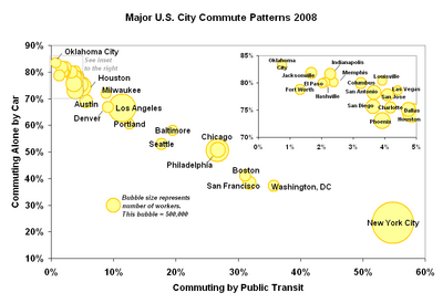
Portland has a good public transportation system. Buses and trains are run by TriMet, which serves three counties around Portland: Multnomah, Clackamas, and Washington. In 2008, about 12.6% of people in Portland used public transport to get to work. This is similar to much larger cities like Los Angeles and higher than most U.S. cities of similar size. If you want to travel between Portland and Vancouver, Washington, you can use C-Tran buses.
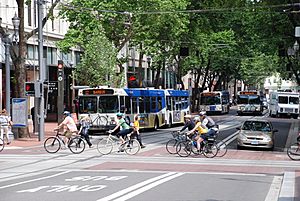
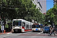
In the heart of downtown, there's a special area called the Portland Transit Mall. This is a street where many buses and light rail trains meet. It first opened in 1977 for buses. In 2009, it was updated to include tracks for light rail trains, called MAX. This big project took over two years to finish. The transit mall reopened for buses in May 2009, and MAX trains started using it in August and September 2009.
For many years, from 1975 to 2012, downtown Portland had a "Fareless Square." This meant you could ride buses, light rail, and streetcars for free in that area. Later, it was changed so only light rail and streetcars were free. But in 2012, the free zone was stopped completely because TriMet needed more money.
The first public transport in Portland was a horsecar line in 1872, started by Ben Holladay. Horses pulled the cars on tracks on First Street. Later, in 1888, the first Steel Bridge was built, allowing trains to cross the Willamette River. Soon, electric streetcars took over from horsecars and steam trains, with the first electric line starting in 1889.
How Do Portland's Buses Work?
TriMet has a fleet of 688 buses that run on 79 different routes. Twelve of these are "Frequent Service" routes, meaning they have buses coming more often. Originally, these routes had buses every 15 minutes or less, all day, every day. Due to budget cuts in 2009, this changed to only during busy weekday mornings and afternoons. However, in 2014, TriMet brought back the 15-minute-or-less wait times for all weekdays on these routes.
TriMet's buses are all modern, built in 2000 or later. They are all "low-floor" buses, which means they are easy to get on and off, especially for people with strollers or wheelchairs. All buses also have air conditioning.
Some bus routes are "express" buses, which means they go faster by making fewer stops. These connect downtown Portland to places like South Beaverton and Oregon City. There are also "cross-town" routes that don't go through downtown. The bus system mostly works like a "hub-and-spoke" network, with downtown Portland as the main hub and other smaller hubs in the suburbs.
TriMet also offers a special service called LIFT for people who cannot use regular bus and train services. It uses minibuses and sedans to provide door-to-door rides.
Exploring Portland with MAX Light Rail
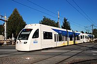
Portland's light rail system is called MAX, which stands for Metropolitan Area Express. Since 2015, it has five different lines, each with its own color:
- The Blue Line is a 33-mile route that goes east and west. It starts in Hillsboro, goes through Beaverton and downtown Portland, crosses the Willamette River, and continues east to Gresham. The first part of this line opened in 1986.
- The Red Line connects the airport to the Gateway Transit Center. From there, it shares tracks with the Blue Line, going west to downtown and ending at the Beaverton Transit Center.
- The Yellow Line is 5.8 miles long and connects North Portland's Expo Center to downtown. It's often called "Interstate MAX" because it runs along Interstate Avenue. In 2009, the Yellow Line started using the new tracks on the Portland Transit Mall.
- The Green Line runs from Clackamas Town Center north along I-205 to the Gateway Transit Center. From Gateway, it joins the Blue and Red Lines to downtown Portland. It then uses new tracks on the transit mall, sharing them with the Yellow Line, and ends at Portland State University.
- The Orange Line is a new 7.3-mile line that opened in 2015. It extends from the south end of the Portland Mall to Milwaukie. This line includes the Tilikum Crossing, a special bridge over the Willamette River that only allows transit vehicles, people walking, and cyclists – no private cars! The Orange Line is connected to the Yellow Line, so southbound Yellow Line trains become Orange Line trains, and northbound Orange Line trains become Yellow Line trains.
Riding the Portland Streetcar
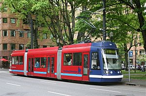
The Portland Streetcar is a system with two lines that serve the central part of Portland, including downtown and nearby areas. The first line opened in 2001. It runs about 3.9 miles from NW 23rd Avenue through areas like the Pearl District and Portland State University to the South Waterfront neighborhood. Here, it connects to the Portland Aerial Tram. This route is called the North-South Line, or NS Line.
The second line opened in 2012 and crosses the Willamette River to the Lloyd District and the Central Eastside. This project cost $148 million and received funding from the federal government. It was originally called the Central Loop Line. In 2015, it was renamed the A Loop (going clockwise) and B Loop (going counterclockwise) when it was extended across the Tilikum Crossing bridge.
There's also the Willamette Shore Trolley, which is a special old-fashioned streetcar service that runs only during certain seasons. Volunteers operate it. It was started in 1990 to help save an old railroad track for possible future public transport use.
Commuter Trains in Portland
TriMet's WES Commuter Rail connects several cities like Wilsonville, Tualatin, Tigard, and Beaverton. It's one of only two train lines in the U.S. that connects suburbs to other suburbs. Unlike MAX, WES uses diesel trains that run on existing freight tracks. It started regular service in February 2009.
Amtrak, the national passenger rail system, also offers train service in the Portland area. The Amtrak Cascades train runs daily between Portland and nearby Oregon City. This ride is faster and often cheaper than other options, and it's quite comfortable.
For more information about trains and buses that travel to and from Portland from outside the metro area, you can check the "Intercity service" section below.
Riding the Portland Aerial Tram
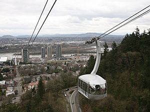
The Portland Aerial Tram is like a cable car that connects the South Waterfront area with Oregon Health and Science University on Marquam Hill, which is higher up. The cableway is about two-thirds of a mile (1 km) long and opened in January 2007.
How Long Do People Spend on Public Transport?
On average, people in Portland spend about 90 minutes commuting with public transport on a weekday. About 36% of riders spend more than 2 hours every day. The average wait time at a stop or station is 14 minutes, but 21% of riders wait for over 20 minutes. The average distance people travel in one trip is 8.2 km, and 18% travel over 12 km in a single direction.
Cycling in Portland
More and more people in Portland are choosing to ride bikes. The number of daily bike riders on four of the Willamette River bridges has grown a lot, from about 2,855 before 1992 to over 16,000 in 2008. This is partly because the city has made it easier and safer to bike. About 8% of people in Portland bike to work, which is the highest percentage among major U.S. cities and about 10 times the national average. In July 2016, Portland launched a bike share program called Biketown, which started with 1,000 bikes.
Walking in Portland
Portland was one of the first cities to create a plan for pedestrians in 1994. The blocks in downtown Portland are quite short, only about 200 feet long, which makes walking easy. While some streets in the outer parts of the city don't have sidewalks, there are many off-street trails for walking. A study in 2011 ranked Portland as the 12th most walkable of the 50 largest cities in the U.S.
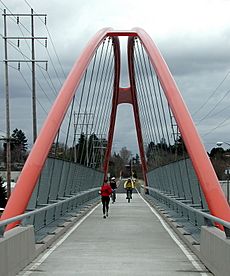
The Gibbs Street Pedestrian Bridge, a bridge for walkers and bikers over I-5 near the Portland Aerial Tram, opened in 2012.
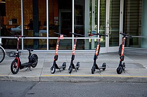
Electric scooter sharing systems have become a popular new way to get around. They first arrived in Portland in July 2018 for a trial period. After a good review, scooters returned in April 2019 for a longer program. These systems work like bike share programs: you use a smartphone app to unlock and pay for a scooter, and then you can leave it anywhere when you're done.
When the program first started, there were some concerns about safety and how well it worked. A city report showed that over 700,000 rides were taken during the trial. It also found that scooters are about as dangerous as other ways of getting around, but many riders didn't follow safety rules, like wearing a helmet.
To address these concerns, Portland made specific rules for scooters. Riders must wear a helmet, be at least 16 years old, not ride on sidewalks or in city parks, and always yield to people walking. The city also worked with scooter companies to offer lower prices for people with lower incomes. There are also options for people who don't have smartphones. The city has also made rules against leaving scooters in the middle of sidewalks.
Despite these efforts, there are still some worries about scooters. People are concerned about whether everyone can access them, especially those with disabilities or in lower-income neighborhoods. Most scooters tend to be in downtown and popular tourist areas. It's also not yet clear if scooters are helping reduce the number of cars on the road, which was one of their main goals. A report found that 34% of local riders used scooters instead of driving, and 48% of visitors used them instead of driving or using a rideshare service.
In June 2019, divers found more than 50 scooters from different companies in the Willamette River. It's not known who put them there or why.
How Traffic Flows in Portland
Many streets in Portland are one-way. In downtown Portland, almost all streets are one-way, forming a grid where traffic alternates direction. For example, on north-south streets, odd-numbered avenues go southbound, and even-numbered avenues go northbound. East-west streets also alternate. This is partly because downtown streets are quite narrow, about 64 feet wide.
Most streets on the east side of Portland are two-way. However, some major routes have "one-way pairs," where two parallel streets carry traffic in opposite directions. Examples include Martin Luther King Jr. Blvd. and Grand Avenue, and 11th and 12th avenues.
Major Highways in Portland
The Portland area has many important highways, including Interstate, U.S., and Oregon Routes. These help people travel in and out of the city and connect to other regions.
 I-5
I-5 I-84
I-84 I-205
I-205 I-405
I-405 US 26
US 26 US 30
US 30
 US 30 Byp.
 OR 8
OR 8 OR 10
OR 10 OR 43
OR 43 OR 99E
 OR 99W
 OR 210
 OR 212
 OR 213
 OR 217
 OR 219
 OR 224
 SR 14
SR 14 SR 500
 SR 503
Some major highways that were planned but never built, or were removed, include the Mount Hood Freeway and Interstate 505.
Portland's Famous Bridges
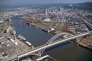
Portland is known as "Bridgetown" because it has so many bridges.
Bridges Over the Willamette River
Here are some of the bridges that cross the Willamette River, listed from north to south:
- St. Johns Bridge (1931) – Carries U.S. Route 30
- Burlington Northern Railroad Bridge 5.1 (1908) – A railroad bridge
- Fremont Bridge (1973) – Carries Interstate 405
- Broadway Bridge (1913) – Carries Broadway
- Steel Bridge (1912) – Carries Pacific Highway West and trains
- Burnside Bridge (1926) – Carries Burnside Street
- Morrison Bridge (1958) – Carries Morrison Street
- Hawthorne Bridge (1910) – Carries Hawthorne Boulevard
- Marquam Bridge (1966) – Carries Interstate 5
- Tilikum Crossing (2015) – The longest bridge in the U.S. that doesn't allow cars
- Ross Island Bridge (1926) – Carries U.S. Route 26
- Sellwood Bridge (1925; replaced in 2016) – Carries SE Tacoma Street
Bridges Over the Columbia River
Here are some bridges that cross the Columbia River, listed from west to east:
- Burlington Northern Railroad Bridge 9.6 (1908) – The first bridge of any kind across the lower Columbia River
- Interstate Bridge (1917/1958) – Carries Interstate 5
- Glenn L. Jackson Memorial Bridge (1982) – Carries Interstate 205
Long-Distance Travel Services
For long-distance train travel, Amtrak trains stop at Union Station in Portland. You can take the Amtrak Cascades to places like Vancouver, British Columbia, and Eugene, Oregon. The Coast Starlight goes to Los Angeles and Seattle, and the Empire Builder connects Portland to Chicago.
Portland also has a good network of long-distance buses. The Cascades POINT bus goes daily between Portland and Eugene. The NorthWest POINT bus travels daily between Portland and Astoria on the coast. BoltBus started offering service from Portland to Seattle in 2012. Other bus services connect Portland to nearby towns like St. Helens, Tillamook, and Bend.
Airports Serving Portland
Portland's main airport is Portland International Airport (PDX), located in the northeast part of the city, near the Columbia River. It's about 20 minutes by car from downtown. You can also get to PDX from downtown using the MAX Red Line. Portland's first airport, Swan Island Municipal Airport, opened in 1927 but closed in the 1940s.
The Hillsboro Airport (HIO) is another important airport, located in Hillsboro, Oregon. It's mainly used for business and private planes and is the second busiest airport in Oregon. You can reach it by the MAX Blue Line.
Troutdale Airport also serves the area. Portland also has Wiley's Seaplane Port, a private base for seaplanes on the Willamette River. The Portland Downtown Heliport is Oregon's only public heliport.
Other Ways to Get Around
People living downtown or in nearby neighborhoods can use car sharing services like Zipcar. As of 2017, there were over 5,000 members sharing 250 cars in neighborhoods like the Pearl District and the Lloyd District.
Skateboarding and roller blading are also popular ways to travel around Portland. Downtown Portland even has "skate routes" signs to guide skaters. The Wall Street Journal once called Portland "the most skateboard-friendly town in America."
 | Leon Lynch |
 | Milton P. Webster |
 | Ferdinand Smith |


