Triple Divide Peak (Tulare County, California) facts for kids
Quick facts for kids Triple Divide Peak |
|
|---|---|

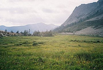
Tamarack Meadow at 9,500 feet (2,900 m), below Triple Divide Peak, in the backcountry of Sequoia National Park
|
|
| Highest point | |
| Elevation | 12,640 ft (3,853 m) NAVD 88 |
| Prominence | 674 ft (205 m) |
| Parent peak | Milestone Mountain |
| Listing |
|
| Geography | |
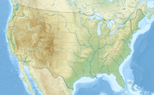
| Location | Sequoia & Kings Canyon National Parks, Tulare County, California, U.S. |
| Parent range | Great Western Divide, Sierra Nevada |
| Topo map | USGS Triple Divide Peak |
| Climbing | |
| First ascent | 1920 James Hutchinson, Charles Noble |
| Easiest route | East Ridge or Southwest Face, scrambles class 2 |
Triple Divide Peak is a special mountain in California, located in the beautiful Sierra Nevada mountain range. It sits right on the border between two amazing national parks: Kings Canyon and Sequoia. This peak is very tall, reaching about 12,640 feet (3,853 meters) high!
Contents
What Makes Triple Divide Peak Special?
Triple Divide Peak gets its name from a unique feature. It is a "triple divide" point. This means that water falling on the peak can flow into three different major watersheds.
The Three Rivers
Near a place called Kaweah Gap, the peak divides the water that eventually flows into three important rivers:
- The Kern River
- The Kaweah River
- The Kings River
Imagine rain or snow falling on the peak. Depending on where it lands, that water will end up in one of these three different river systems. This is why it's called "Triple Divide Peak."
Other Names for the Peak
At one time, this mountain was also known by another name: The Keystone. This name also suggests its central and important position.
Nearby Mountain Ridges
Triple Divide Peak is connected to other mountain ridges in the area.
- The Kaweah Peaks Ridge branches off to the south of the peak.
- The Kings-Kaweah Divide extends from the peak towards the west.
These ridges are part of the larger Great Western Divide within the Sierra Nevada.
Exploring Triple Divide Peak
Triple Divide Peak is a popular spot for mountaineers and hikers. It offers amazing views of the surrounding national parks.
First Climbers of the Peak
The first recorded climb to the top of Triple Divide Peak happened in 1920. It was achieved by two climbers, James Hutchinson and Charles Noble.
How to Reach the Summit
Climbing Triple Divide Peak is considered a scramble, which means it involves some easy climbing over rocks. The easiest ways to reach the top are usually along the East Ridge or the Southwest Face. These routes are rated as a scramble class 2, meaning they are not extremely difficult but require some basic climbing skills.
 | John T. Biggers |
 | Thomas Blackshear |
 | Mark Bradford |
 | Beverly Buchanan |


