
Tumtum Peak facts for kids
Quick facts for kids Tumtum Peak |
|
|---|---|

East aspect
|
|
| Highest point | |
| Elevation | 4,678 ft (1,426 m) |
| Prominence | 1,078 ft (329 m) |
| Isolation | 2.19 mi (3.52 km) |
| Parent peak | Mount Wow (6,040 ft) |
| Geography | |

Tumtum Peak
Location in Washington (state)

Tumtum Peak
Location in the United States
|
|
| Location | Mount Rainier National Park Pierce County, Washington, U.S. |
| Parent range | Cascades |
| Topo map | USGS Wahpenayo Peak |
| Geology | |
| Age of rock | Eocene |
| Type of rock | Ohanapecosh Formation |
| Climbing | |
| Easiest route | scrambling |
Tumtum Peak is a mountain located in the southwest part of Mount Rainier National Park in Washington state. It stands about 4,678 feet (1,426 meters) tall. This peak is covered in trees from top to bottom and is part of the Cascade Range. It is about 8.7 miles (14 km) southwest of the famous Mount Rainier.
Water from Tumtum Peak flows into Tahoma Creek and Kautz Creek. Both of these creeks eventually join the Nisqually River. A road called the Road to Paradise goes along the southern base of the peak. This is one of the first things visitors see after entering the park through the Nisqually Entrance. The mountain rises steeply, climbing almost 2,500 feet (762 meters) above the road in just one mile.
Contents
What's in a Name?
The name "Tumtum" comes from a language called Chinook Jargon. In this language, "tumtum" means "heart" or "heartbeat." The mountain was given this name because of its shape, which reminded people of a heart. The name was officially recognized in 1913 by the United States Board on Geographic Names.
Mountain Weather
Tumtum Peak is in a place with a marine west coast climate. This means it gets a lot of moisture from the Pacific Ocean. Weather systems usually move from the Pacific Ocean towards the Cascade Range. When these systems hit the tall mountains, the air is forced to rise. As the air goes up, it cools down and drops its moisture as rain or snow.
Because of this, the western side of the Cascades, where Tumtum Peak is, gets a lot of rain and snow, especially in winter. Winters are often cloudy. However, in summer, high-pressure systems over the Pacific Ocean usually bring clear skies and sunshine.
Gallery
-
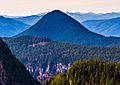
Tumtum Peak seen from Inspiration Point
-
Tumtum Peak seen from Inspiration Point

.jpg)
See also
- Geology of the Pacific Northwest
