Typhoon Lekima (2019) facts for kids
- This storm is about the storm in 2019. For other storms of the same name, see Typhoon Lekima.
| Typhoon (JMA scale) | |
|---|---|
| Category 4 super typhoon (SSHWS) | |

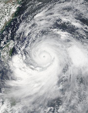
Typhoon Lekima at peak intensity on August 8
|
|
| Formed | August 2, 2019 |
| Dissipated | August 14, 2019 |
| Highest winds | 10-minute sustained: 195 km/h (120 mph) 1-minute sustained: 240 km/h (150 mph) |
| Lowest pressure | 920 hPa (mbar); 27.17 inHg |
| Fatalities | 89 total |
| Damage | $7.6 billion (2019 USD) |
| Areas affected | Caroline Islands, East China, Philippines, Ryukyu Islands, Taiwan |
| Part of the 2019 Pacific typhoon season | |
Typhoon Lekima, also called Typhoon Hanna in the Philippines, was a very powerful and damaging storm in 2019. It caused a lot of destruction, especially in China. In fact, it was one of the most expensive typhoons in Chinese history.
Lekima was the ninth named storm of the 2019 Pacific typhoon season. It started as a small weather system near the Philippines. Over time, it grew stronger and became a huge typhoon.
Lekima caused a lot of rain in the Philippines, which led to floods and accidents. In mainland China, the typhoon caused massive damage, affecting many people and costing billions of dollars. It also caused some damage in the Ryukyu Islands and Taiwan.
Contents
How Typhoon Lekima Formed and Grew
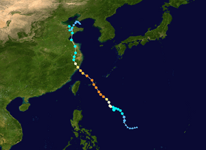
On August 2, 2019, weather experts in Japan started watching a tropical depression. This is like a baby storm, forming over the Philippine Sea. It slowly got bigger as it moved north.
By August 4, it had grown into a tropical storm and was given the name Lekima. Even though there were some winds that tried to break it apart, Lekima kept getting stronger. This was because the ocean water was very warm, about 31 degrees Celsius (88 degrees Fahrenheit).
Lekima Becomes a Super Typhoon
On August 6, Lekima sped up and moved towards the northwest. It became a severe tropical storm, then quickly grew into a full typhoon. Weather satellites showed it had a clear "eye" in its center.
On August 8, Lekima became a "super typhoon." This means it was incredibly powerful, like a Category 4 hurricane. At its strongest, its winds reached about 195 kilometers per hour (120 miles per hour). At this time, Lekima passed between two islands, Miyako-jima and Tarama-jima.
Lekima Weakens and Makes Landfall
After reaching its peak strength, Lekima started to change. It went through something called an "eyewall replacement cycle." This is when a typhoon's eye gets bigger, and it can sometimes make the storm weaker.
As Lekima moved closer to East China, the weather conditions became less favorable. This caused the typhoon to slowly lose strength. On August 10, Lekima made its first landfall in Wenling, Zhejiang, China. Its winds were still very strong, around 185 kilometers per hour (115 miles per hour).
After hitting land, Lekima weakened quickly. It moved north and then went out over the Yellow Sea. On August 11, it made a second landfall in Shandong, China. By this point, it was much weaker, with winds around 85 kilometers per hour (53 miles per hour). Lekima continued to weaken and eventually became just a tropical depression by August 12.
Lekima's Impact on Different Countries
Impact in the Philippines
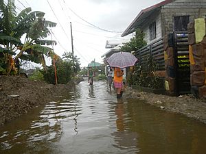
Even though Lekima (known as "Hanna" there) didn't directly hit the Philippines, it made the southwest monsoon much stronger. This brought very heavy rain to the country.
The heavy rains caused serious flooding, especially in Metro Manila. Sadly, three boats sank in the Guimaras Strait, and this accident caused 31 deaths. Another boat also capsized near Mactan Island. The strong waves from Lekima also forced over 1,300 people to leave their homes in Davao City. Farmers in Central Luzon lost about ₱80.5 million (US$1.55 million) worth of crops.
Impact in the Ryukyu Islands
As Lekima approached the southwestern Ryukyu Islands in Japan, people were warned about high waves, heavy rain, and strong winds. Winds on Miyako-jima reached 168 kilometers per hour (104 miles per hour).
Six people were injured during the storm, and thousands of homes lost electricity. Many flights and boat trips were canceled from August 7-9, affecting thousands of travelers. The damage to farms across the islands was about JP¥347 million (US$3.29 million).
Impact in Taiwan
Taiwan's weather agency issued warnings as Lekima got closer. Schools and workplaces were closed in northern Taiwan and the Matsu Islands on August 9. Many flights and ships were also canceled or delayed.
In Taiwan, Lekima sadly caused two deaths and injured 15 people. Over 80,000 families experienced power outages. Some areas, like Wufeng Township, received a huge amount of rain, about 385 millimeters (15 inches). Interestingly, Lekima's winds also caused very hot temperatures in some areas, with one farm recording 39.9 degrees Celsius (103.8 degrees Fahrenheit). The total damage in Taiwan, including from a recent earthquake, was about NT$5.24 million (US$167,000).
Impact in Mainland China
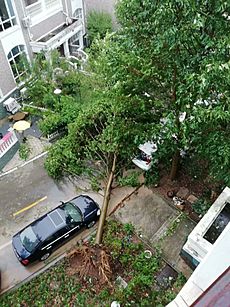
Lekima caused huge damage across many provinces in East China. In total, the typhoon caused 56 deaths and 14 people went missing. The total cost of damage across China was an estimated CN¥53.72 billion (US$7.6 billion).
Zhejiang province was hit the hardest. In this province, 39 people died. Most of these deaths were due to landslides in Yongjia County. These landslides blocked a river, causing water levels to rise by 10 meters (33 feet) in just ten minutes. Many residents couldn't escape in time. The city of Wenling saw wind gusts of 221 kilometers per hour (137 miles per hour).
Shandong province also experienced significant effects from Lekima, with 5 deaths and CN¥1.475 billion (US$209 million) in damage. Because Lekima lingered over Shandong for several days, it brought very heavy rainfall.
Impact in Malaysia
The outer parts of Lekima reached Malaysia on August 9. This caused widespread damage and injured 10 people in the northern states of Kedah, Penang, and Perlis. The storm also damaged 329 schools. Winds in some areas reached 100 kilometers per hour (62 miles per hour).


