Villa Park, Illinois facts for kids
Quick facts for kids
Villa Park
|
|
|---|---|
|
Village
|
|
| Village of Villa Park | |

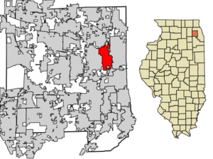
Location of Villa Park in DuPage County, Illinois.
|
|
| Country | United States |
| State | Illinois |
| County | DuPage |
| Townships | York, Addison |
| Incorporated | 1914 |
| Government | |
| • Type | Council–manager |
| Area | |
| • Total | 4.77 sq mi (12.35 km2) |
| • Land | 4.72 sq mi (12.23 km2) |
| • Water | 0.04 sq mi (0.12 km2) 1.05% |
| Population
(2020)
|
|
| • Total | 22,263 |
| • Density | 4,713.74/sq mi (1,820.16/km2) |
| Down 0.81% from 1990 | |
| Standard of living | |
| • Median income | $77,739 (average household: $91,386) |
| • Median home value | $245,800 |
| ZIP code(s) |
60181
|
| Area code(s) | 630 and 331 |
| Geocode | 77993 |
| FIPS code | 17-77993 |
Villa Park is a village in DuPage County, Illinois, United States. It is part of the larger Chicago metropolitan area. In 2020, about 21,113 people lived there.
Contents
History of Villa Park
Villa Park started because the Ovaltine factory needed a good way for its workers to get to work. It was also a handy train stop.
Two neighborhoods, Villa Park (built in 1908) and Ardmore (built in 1910), joined together in 1914 to form the village. About 300 people lived there at the time. The first village president, William H. Calhoun, was chosen on September 12, 1914. Even though the combined town was first called Ardmore, its name changed to Villa Park in 1917.
Villa Park grew a lot because of an electric train line called the Chicago Aurora and Elgin Railroad. This train went from downtown Chicago to places like Wheaton, Illinois, Aurora, and Elgin. Two small shopping areas grew around the train stations at Villa Avenue and Ardmore Avenue.
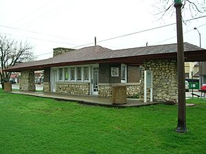
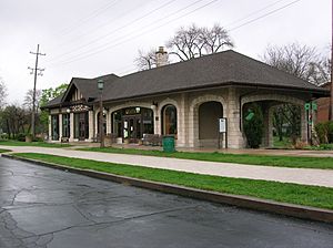
In 1957, the train stopped carrying passengers. This was because more people started using cars and a new highway, the Eisenhower Expressway, made train travel less convenient. The old train tracks were later turned into a walking and biking trail called the Illinois Prairie Path. Today, the Ardmore Station is home to the Chamber of Commerce, and the Villa Avenue Station houses the Villa Park Historical Society.
The Ovaltine chocolate factory was in Villa Park until it closed in 1988. It is now a historic building and has been turned into apartments.
Many people living in Villa Park have roots in Eastern Europe, like Poland, Czech Republic, and Russia. There is also a large Hispanic community. In the 1980s and 1990s, a Muslim immigrant community grew in the area and started the Islamic Foundation School in 1986.
The Villa Park Public Library was updated and expanded between 2015 and 2019. The new library opened in October 2019.
Geography of Villa Park
Villa Park is located at 41°53′19″N 87°58′40″W / 41.88861°N 87.97778°W.
The village covers about 4.77 square miles (12.35 square kilometers). Most of this area, about 4.72 square miles (12.23 square kilometers), is land. A small part, about 0.05 square miles (0.12 square kilometers), is water.
Population and People
| Historical population | |||
|---|---|---|---|
| Census | Pop. | %± | |
| 1920 | 854 | — | |
| 1930 | 6,220 | 628.3% | |
| 1940 | 7,236 | 16.3% | |
| 1950 | 8,821 | 21.9% | |
| 1960 | 20,391 | 131.2% | |
| 1970 | 25,891 | 27.0% | |
| 1980 | 23,155 | −10.6% | |
| 1990 | 22,253 | −3.9% | |
| 2000 | 22,075 | −0.8% | |
| 2010 | 21,904 | −0.8% | |
| 2020 | 22,263 | 1.6% | |
| U.S. Decennial Census | |||
Villa Park Population in 2020
In 2020, Villa Park had 22,263 people. There were 8,000 households and 5,575 families living in the village. The population density was about 4,669 people per square mile (1,820 people per square kilometer).
The village is home to a diverse group of people. According to the 2020 census:
| Race / Ethnicity (NH = Non-Hispanic) | Pop 2000 | Pop 2010 | Pop 2020 | % 2000 | % 2010 | % 2020 |
|---|---|---|---|---|---|---|
| White alone (NH) | 17,820 | 15,639 | 13,950 | 80.72% | 71.40% | 62.66% |
| Black or African American alone (NH) | 368 | 908 | 995 | 1.67% | 4.15% | 4.47% |
| Native American or Alaska Native alone (NH) | 25 | 26 | 32 | 0.11% | 0.12% | 0.14% |
| Asian alone (NH) | 804 | 1,129 | 1,348 | 3.64% | 5.15% | 6.05% |
| Pacific Islander alone (NH) | 3 | 1 | 3 | 0.01% | 0.00% | 0.01% |
| Other race alone (NH) | 17 | 14 | 85 | 0.08% | 0.06% | 0.38% |
| Mixed race or Multiracial (NH) | 268 | 293 | 766 | 1.21% | 1.34% | 3.44% |
| Hispanic or Latino (any race) | 2,770 | 3,894 | 5,084 | 12.55% | 17.78% | 22.84% |
| Total | 22,075 | 21,904 | 22,263 | 100.00% | 100.00% | 100.00% |
About 23.4% of the population was under 18 years old. The average age in the village was 37.2 years.
Economy and Jobs
Villa Park has several important employers. Here are the top five employers in the village as of 2021:
| # | Employer | # of Employees |
|---|---|---|
| 1 | Mc Afee, LLC | 417 |
| 2 | Clayco, Inc | 412 |
| 3 | Commonwealth Edison Group | 301 |
| 4 | Village of Villa Park | 225 |
| 5 | First Student | 191 |
Transportation in Villa Park
Villa Park has a commuter train station on Metra's Union Pacific West Line. This train line connects Villa Park to Elburn, Illinois in the west and downtown Chicago in the east.
The Ardmore Avenue Train Station and the Villa Avenue Train Station are both historic places. The Ardmore Avenue Train Station is now the home of the Villa Park Chamber of Commerce. The Villa Avenue Train Station houses the Villa Park Historical Museum.
Both of these old train stations are located along the Illinois Prairie Path. This path is popular for biking and walking, especially when the weather is warm. In winter, people use it for cross-country skiing. The Salt Creek Trail and Great Western Trail are also nearby.
Pace provides bus services in Villa Park. Routes 301 and 313 connect the village to places like Forest Park and Wheaton.
Notable People from Villa Park
Many interesting people have connections to Villa Park, including:
- Norma Berger, a pitcher who played in the All-American Girls Professional Baseball League.
- Tom Cullerton, a former member of the Illinois Senate.
- Tino Insana, an actor, voice actor, writer, and producer.
- John Kennedy, a driver for NASCAR.
- Anita Padilla, a reporter for WFLD-TV in Chicago.
- Matt Roth, a former NFL football player.
- Bobby Wawak, a driver for NASCAR.
See also
 In Spanish: Villa Park (Illinois) para niños
 | May Edward Chinn |
 | Rebecca Cole |
 | Alexa Canady |
 | Dorothy Lavinia Brown |


