
Wainfleet All Saints facts for kids
Quick facts for kids Wainfleet All Saints |
|
|---|---|
 Salem Bridge Mill, Wainfleet |
|

Wainfleet All Saints
|
|
| Population | 1,604 (2011 census) |
| OS grid reference | TF498591 |
| • London | 115 mi (185 km) S |
| Civil parish |
|
| District | |
| Shire county | |
| Region | |
| Country | England |
| Sovereign state | United Kingdom |
| Post town | Skegness |
| Postcode district | PE24 |
| Dialling code | 01754 |
| Police | Lincolnshire |
| Fire | Lincolnshire |
| Ambulance | East Midlands |
| EU Parliament | East Midlands |
| UK Parliament |
|
Wainfleet All Saints is an old port and market town on the east coast of England. It is located in the East Lindsey area of Lincolnshire. The town is about 5 kilometres (3 miles) south-west of Skegness and 14 kilometres (9 miles) north-east of Boston.
Wainfleet All Saints sits on two small rivers, the Steeping and Limb (or Lymn). These rivers come together to form Wainfleet Haven. The town is also close to the Lincolnshire Wolds, which are rolling hills. The nearby village of Wainfleet St Mary is to the south. In 2011, about 1,604 people lived in the town.
Contents
History and Important Places
The name "Wainfleet" comes from an old English word meaning "a stream that a wagon can cross." The town is built on or near an old Roman settlement called Vainona. There are two large mounds, called tumuli, near the town. One is to the north and one to the south. No one knows for sure where they came from, but some think they might be Viking or Roman. Old coins from those times have been found nearby. In the Domesday Book of 1086, Wainfleet was called 'Wenflet'.
The main church in town, All Saints, was built in 1820-21. It replaced an older church that was taken down. Some materials from the old church were used to build the new one. Another church, St Thomas, was already gone by then. During the demolition of the old All Saints church, the tomb of Richard Patten was broken. He was the father of William of Waynflete. His tomb was later put back together in Magdalen College Chapel in Oxford.
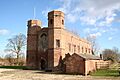
William of Waynflete started the town's Magdalen College School in 1484. He also helped the town get a special document called a charter of incorporation in 1457. This charter gave the town more rights and power. The school building is a Grade I listed building, which means it's very important historically. Today, it is a museum.
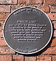
In 1847, a street called Barkham Street was built. It has houses in a style similar to those in London. Bethlem Hospital asked for these houses to be built.
The Market Place has two Grade II listed structures. One is a clock tower put up in 1899. The other is a 15th-century Buttercross. A Buttercross is a stone cross where people used to sell butter and other dairy products. This one is made of limestone and has three steps. It has a finial (a decorative top) and a weathervane from the 1800s. John Wesley, a famous preacher, once preached from this Buttercross.
Wainfleet is also known for Batemans Brewery. The brewery building includes an old Georgian house called Salem House. It also has a former corn mill called Salem Bridge Mill. Some pubs in Wainfleet are the Woolpack Hotel and The Angel.
Skegness Grammar School has a boarding house in Wainfleet for students who live there. Wainfleet became a special "conservation area" in 1972. This means its historic character is protected.
Getting Around (Transport)
Wainfleet used to be the end of a railway line, the Great Northern Railway. This was before Skegness, about 6 miles (10 km) to the east, grew bigger. Today, Wainfleet railway station is on Station Road. It is part of the Nottingham to Skegness Line.
Work on a bypass for the A52 around Wainfleet started in February 1990. It cost £1.82 million and took 60 weeks to build. The bypass opened in February 1991.
Sports and Activities
The Wainfleet & District Sporting Motorcycle Club hosts Motorcycle Grasstrack Racing events. They have held the International Lincolnshire Poacher race every year since 1992. The club has also hosted the British Masters Championship four times. In 2011, they hosted the European Grasstrack Championship Final at their home track in Thorpe St Peter.
News and Media
Local news and TV shows for Wainfleet come from BBC Yorkshire and Lincolnshire and ITV Yorkshire. TV signals are received from the Belmont TV transmitter.
Local radio stations include BBC Radio Lincolnshire, Greatest Hits Radio Lincolnshire, and Hits Radio Lincolnshire.
The town also has local newspapers like the Skegness Standard and the Lincolnshire Echo.
Northolme Hamlet
At the northern end of Wainfleet All Saints is a small village called Northolme. This is all that is left of an old parish called Wainfleet St Thomas.
For a long time, people didn't really tell the difference between Wainfleet All Saints, Wainfleet St Mary, and Wainfleet St Thomas. But a document from the 1200s mentions North Wenfled.
In 1316, Wainfleet St Thomas was mentioned for paying taxes. During the Reformation, a chapel in Northolme belonged to Kyme Priory. No one knows exactly when this chapel was taken down. It was still standing during the Protectorate period, when a group called the General Baptists used it. Today, nothing remains of the chapel, but its site is now part of the local cemetery.
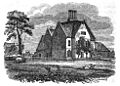
In 1546, Thomas Lyttlebury inherited the manor of Northolme. However, the estate later went to his brother John's daughter, Alice. She married Thomas Upton, and his family lived at Northolme Hall.
The first Northolme Hall was a large manor house built around 1549. It was surrounded by a moat. The current Northolme Hall was built in 1866 on the same spot.
Population Over Time
| Population of Wainfleet All Saints Civil Parish | ||||||||||||||||||||||||||||||||||||||||||||||||||||||||||||||
|---|---|---|---|---|---|---|---|---|---|---|---|---|---|---|---|---|---|---|---|---|---|---|---|---|---|---|---|---|---|---|---|---|---|---|---|---|---|---|---|---|---|---|---|---|---|---|---|---|---|---|---|---|---|---|---|---|---|---|---|---|---|---|
|
|
|
||||||||||||||||||||||||||||||||||||||||||||||||||||||||||||
| Sources: | ||||||||||||||||||||||||||||||||||||||||||||||||||||||||||||||
Geography and Location
 |
Thorpe St Peter, Firsby, Spilsby | Burgh Le Marsh, Orby, Alford | Croft, Skegness | |
| Midville, Stickney, Coningsby | Gibraltar Point | |||
| Wainfleet St Mary, Friskney, Wrangle, Boston |
Wainfleet is located south of Skegness and north of Boston. It is on the A52.
Weather (Climate)
| Climate data for Wainfleet (1991–2020) | |||||||||||||
|---|---|---|---|---|---|---|---|---|---|---|---|---|---|
| Month | Jan | Feb | Mar | Apr | May | Jun | Jul | Aug | Sep | Oct | Nov | Dec | Year |
| Mean daily maximum °C (°F) | 7.0 (44.6) |
7.6 (45.7) |
9.9 (49.8) |
12.6 (54.7) |
15.6 (60.1) |
18.5 (65.3) |
20.9 (69.6) |
21.3 (70.3) |
18.4 (65.1) |
14.3 (57.7) |
10.1 (50.2) |
7.3 (45.1) |
13.7 (56.7) |
| Mean daily minimum °C (°F) | 1.9 (35.4) |
1.8 (35.2) |
3.0 (37.4) |
4.7 (40.5) |
7.4 (45.3) |
10.2 (50.4) |
12.2 (54.0) |
12.3 (54.1) |
10.3 (50.5) |
8.0 (46.4) |
4.4 (39.9) |
2.1 (35.8) |
6.5 (43.7) |
| Average rainfall mm (inches) | 50.7 (2.00) |
40.9 (1.61) |
38.1 (1.50) |
38.9 (1.53) |
48.4 (1.91) |
56.6 (2.23) |
58.1 (2.29) |
62.7 (2.47) |
52.0 (2.05) |
65.3 (2.57) |
59.5 (2.34) |
54.6 (2.15) |
625.8 (24.64) |
| Average rainy days (≥ 1 mm) | 11.3 | 10.3 | 8.8 | 8.2 | 8.1 | 9.3 | 9.6 | 9.8 | 8.7 | 11.2 | 12.4 | 11.8 | 119.6 |
| Source: Met Office | |||||||||||||
Images for kids
-
Magdalen College School building, now a museum
-
Barkham Street - wall plaque
-
The first Northolme Hall
-
The Wainfleet relief channel in 2007


See also
 In Spanish: Wainfleet All Saints para niños
