Waller County, Texas facts for kids
Quick facts for kids
Waller County
|
|
|---|---|

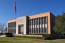
The Waller County Courthouse in Hempstead
|
|

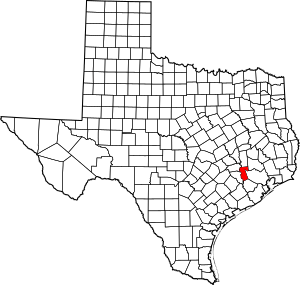
Location within the U.S. state of Texas
|
|
 Texas's location within the U.S. |
|
| Country | |
| State | |
| Founded | 1873 |
| Named for | Edwin Waller |
| Seat | Hempstead |
| Largest city | Prairie View |
| Area | |
| • Total | 518 sq mi (1,340 km2) |
| • Land | 513 sq mi (1,330 km2) |
| • Water | 4.4 sq mi (11 km2) 0.8% |
| Population
(2020)
|
|
| • Total | 56,794 |
| • Density | 109.64/sq mi (42.33/km2) |
| Time zone | UTC−6 (Central) |
| • Summer (DST) | UTC−5 (CDT) |
| Congressional district | 10th |
Waller County is a county located in the state of Texas in the United States. It's part of the larger Houston area. In 2020, about 56,794 people lived here. The main town and county seat is Hempstead.
The county is named after Edwin Waller. He was an important person who signed the Texas Declaration of Independence. He was also the first mayor of Austin, the capital city of Texas. Waller County is also home to Prairie View A&M University, a well-known college.
Contents
Exploring Waller County's Geography
Waller County covers a total area of about 518 square miles. Most of this area is land. Only a small part, about 4.4 square miles, is covered by water.
Neighboring Counties Around Waller
Waller County shares its borders with several other counties. These are like its neighbors on a map:
- Grimes County to the north
- Montgomery County to the northeast
- Harris County to the east
- Fort Bend County to the south
- Austin County to the west
- Washington County to the northwest
Communities and Towns in Waller County
Waller County has several towns and cities where people live. Some are larger cities, while others are smaller towns or unincorporated areas.
Cities in Waller County
- Brookshire
- Hempstead (This is the county seat, meaning it's where the county government is located.)
- Katy (Part of Katy is in Waller County, but it also stretches into Harris and Fort Bend Counties.)
- Pattison
- Prairie View
- Waller (Part of Waller is also in Harris County.)
Town in Waller County
Unincorporated Areas in Waller County
These are places where people live that are not part of an official city or town.
- Fields Store
- Monaville
- Second Corinth
- Shiloh
- Sunny Side
Who Lives in Waller County?
The number of people living in Waller County has grown a lot over the years. In 1880, there were just over 9,000 people. By 2020, the population had grown to 56,794.
| Historical population | |||
|---|---|---|---|
| Census | Pop. | %± | |
| 1880 | 9,024 | — | |
| 1890 | 10,888 | 20.7% | |
| 1900 | 14,246 | 30.8% | |
| 1910 | 12,138 | −14.8% | |
| 1920 | 10,292 | −15.2% | |
| 1930 | 10,014 | −2.7% | |
| 1940 | 10,280 | 2.7% | |
| 1950 | 11,961 | 16.4% | |
| 1960 | 12,071 | 0.9% | |
| 1970 | 14,285 | 18.3% | |
| 1980 | 19,798 | 38.6% | |
| 1990 | 23,390 | 18.1% | |
| 2000 | 32,663 | 39.6% | |
| 2010 | 43,205 | 32.3% | |
| 2020 | 56,794 | 31.5% | |
| 2023 (est.) | 63,553 | 47.1% | |
| U.S. Decennial Census 1850–2010 2010–2020 |
|||
Diversity in Waller County's Population
Waller County is home to people from many different backgrounds. The U.S. Census keeps track of this diversity. In 2020, about 41% of the people were White (not Hispanic). About 21% were Black or African American.
The number of Hispanic or Latino people has grown quite a bit. In 2000, they made up about 19% of the population. By 2020, this group had grown to about 32.5% of all residents. This shows how the county's population is becoming more diverse.
Waller County's Economy and Businesses
Waller County is home to some important businesses. These companies provide jobs and help the local economy.
Major Companies in Waller County
- Igloo Corporation: This company makes coolers and portable refrigerators. Their main office, factories, and distribution centers are all located in Waller County. They moved all their operations here in 2004.
- Goya Foods: This well-known food company has its Texas offices in Waller County, near Brookshire.
Education and Learning in Waller County
Waller County has several school districts that serve its students. There are also colleges and a university for higher education.
School Districts Serving Waller County Students
- Hempstead Independent School District
- Royal Independent School District
- Katy Independent School District (Parts of this district are also in other counties.)
- Waller Independent School District (Parts of this district are also in other counties.)
Colleges and Universities in Waller County
- Blinn College: This is a community college that serves all of Waller County.
- Houston Community College: Students in the Katy ISD part of Waller County can also attend this college.
- Prairie View A&M University: This is the only university located directly within Waller County.
Local News in Waller County
The Waller Times is the main local newspaper for Waller County. It publishes news about the community, schools, and sports every Monday. The newspaper started in 1991 and is still run by the same family.
Getting Around Waller County: Transportation
Waller County has important highways and airports that help people travel.
Major Highways in Waller County
Several major roads pass through Waller County, making it easy to get to other parts of Texas:
 Interstate 10
 U.S. Highway 90
 U.S. Highway 290
 State Highway 6
 State Highway 159
Airports in Waller County
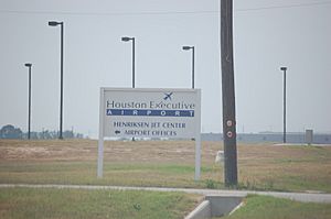
- Houston Executive Airport: This airport is located between Brookshire and Katy.
- Skydive Houston Airport (Skylake Airport): This airport is south of Waller.
For bigger flights, people in Waller County usually use George Bush Intercontinental Airport or William P. Hobby Airport. Both of these are international airports located in nearby Houston.
Images for kids
See also
 In Spanish: Condado de Waller para niños
 | Victor J. Glover |
 | Yvonne Cagle |
 | Jeanette Epps |
 | Bernard A. Harris Jr. |


