Washington County, Texas facts for kids
Quick facts for kids
Washington County
|
|
|---|---|

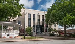
The Washington County Courthouse in Brenham
|
|

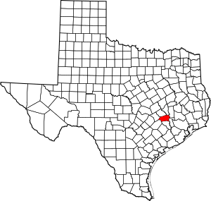
Location within the U.S. state of Texas
|
|
 Texas's location within the U.S. |
|
| Country | |
| State | |
| Founded | 1837 |
| Named for | George Washington |
| Seat | Brenham |
| Largest city | Brenham |
| Area | |
| • Total | 622 sq mi (1,610 km2) |
| • Land | 604 sq mi (1,560 km2) |
| • Water | 18 sq mi (50 km2) 2.9% |
| Population
(2020)
|
|
| • Total | 35,805 |
| • Density | 58/sq mi (22/km2) |
| Time zone | UTC−6 (Central) |
| • Summer (DST) | UTC−5 (CDT) |
| Congressional district | 10th |
Washington County is a county in Texas. In 2020, about 35,805 people lived there. The main town, called the county seat, is Brenham. Brenham is located along U.S. Highway 290, about 72 miles northwest of Houston.
This county was first set up in 1835 as an area belonging to Mexico. It officially became a county in 1837. It is named after George Washington, who was the first president of the United States. Washington County is part of the Brenham area, which is also connected to the larger Houston-The Woodlands region.
Washington-on-the-Brazos is a very important place in the county. This is where the Texas Declaration of Independence was signed in 1836. Many German immigrants came to Washington County in the mid-1800s after the 1848 German revolutions. Because of this, in the year 2000, more than one-third of the people living here said they had German family roots.
Contents
Where is Washington County?
According to the U.S. Census Bureau, Washington County covers a total area of 622 square miles. About 18 square miles of this area is covered by water, which is about 2.9% of the total.
Main Roads in the County
Neighboring Counties
Washington County shares borders with these other counties:
- Brazos County (north)
- Grimes County (northeast)
- Waller County (east)
- Austin County (south)
- Fayette County (southwest)
- Lee County (west)
- Burleson County (northwest)
Population and People
| Historical population | |||
|---|---|---|---|
| Census | Pop. | %± | |
| 1850 | 5,983 | — | |
| 1860 | 15,215 | 154.3% | |
| 1870 | 23,104 | 51.9% | |
| 1880 | 27,565 | 19.3% | |
| 1890 | 29,161 | 5.8% | |
| 1900 | 32,931 | 12.9% | |
| 1910 | 25,561 | −22.4% | |
| 1920 | 26,624 | 4.2% | |
| 1930 | 25,394 | −4.6% | |
| 1940 | 25,387 | 0.0% | |
| 1950 | 20,542 | −19.1% | |
| 1960 | 19,145 | −6.8% | |
| 1970 | 18,842 | −1.6% | |
| 1980 | 21,998 | 16.7% | |
| 1990 | 26,154 | 18.9% | |
| 2000 | 30,373 | 16.1% | |
| 2010 | 33,718 | 11.0% | |
| 2020 | 35,805 | 6.2% | |
| U.S. Decennial Census 1850–2010 2010 2020 |
|||
| Group (NH = Not Hispanic) | Pop 2010 | Pop 2020 | % 2010 | % 2020 |
|---|---|---|---|---|
| White alone (NH) | 22,394 | 22,023 | 66.42% | 61.51% |
| Black or African American alone (NH) | 5,861 | 5,555 | 17.38% | 15.51% |
| Native American or Alaska Native alone (NH) | 61 | 75 | 0.18% | 0.21% |
| Asian alone (NH) | 432 | 547 | 1.28% | 1.53% |
| Pacific Islander alone (NH) | 7 | 14 | 0.02% | 0.04% |
| Other race alone (NH) | 34 | 140 | 0.10% | 0.39% |
| Mixed race or multiracial (NH) | 288 | 1,026 | 0.85% | 2.87% |
| Hispanic or Latino (any race) | 4,641 | 6,425 | 13.76% | 17.94% |
| Total | 33,718 | 35,805 | 100.00% | 100.00% |
In 2000, there were 30,373 people living in Washington County. There were 11,322 households and 7,936 families. The county had about 50 people per square mile.
Most people in the county were White (74.68%). About 18.66% were African American. Many people had German (33.6%), American (6.1%), English (5.7%), Irish (5.3%), or Polish (5.0%) family backgrounds. Most people spoke English (88.1%), but some also spoke Spanish (8.6%) or German (1.2%).
About 31.6% of households had children under 18. More than half (54.8%) were married couples. The average household had 2.53 people. The average family had 3.05 people.
The median age in the county was 37 years old. This means half the people were younger than 37 and half were older. For every 100 females, there were about 94.7 males.
The median income for a household was $36,760. For a family, it was $43,982. About 12.9% of the population lived below the poverty line. This included 14.8% of those under 18 and 14.5% of those 65 or older.
Towns and Communities
Cities
Unincorporated Communities
These are smaller towns or areas that are not officially cities.
- Berlin
- Chappell Hill
- Greenvine
- Independence
- Latium
- Longpoint
- Mill Creek
- Phillipsburg‡
- Prairie Hill
- Quarry
- Sandy Hill
- Washington-on-the-Brazos
- Wesley
- Whitman
- Wiedeville
- William Penn
Historic Communities
Many old communities in Washington County have changed or disappeared over time. In 1900, a speaker named Harry Haynes said that many places like Tiger Point, Union Hill, and Old Gay Hill were "blotted from the face of this beautiful earth" due to new conditions.
- Ayres
- Cedar Creek – a mile north of Chappell Hill
- Coles Settlement
- Gay Hill
- Goodwill
- Graball
- Mt. Vernon – This was the county seat from 1841 to 1843.
- Muellersville
- Rock Island
- Tigertown
- Winklemann – a tourist town with one owner
- Yegua
- Zionville
Education in Washington County
Here are the school districts that serve Washington County:
- Brenham Independent School District
- Burton Independent School District
- Giddings Independent School District
- Hallettsville Independent School District
Blinn College is the community college for everyone in Washington County. This means that students from Washington County pay less for tuition at Blinn College.
See also
 In Spanish: Condado de Washington (Texas) para niños
 | Claudette Colvin |
 | Myrlie Evers-Williams |
 | Alberta Odell Jones |


