Walnut Creek (California) facts for kids
Quick facts for kids Walnut Creek |
|
|---|---|

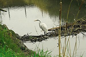
Secondary beaver dam on lower Walnut Creek provides happy hunting perch for a great egret. Courtesy Cheryl Reynolds, Worth a Dam, 2013
|
|
|
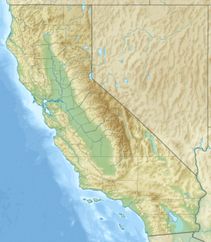
Location of the mouth of Walnut Creek in California
|
|
| Other name(s) | Arroyo de Las Nueces, Arroyo de Los Nogales |
| Country | United States |
| State | California |
| Region | Contra Costa County |
| Cities | Walnut Creek, Pleasant Hill, Four Corners, Concord, Pacheco, Vine Hill, Mococo, Martinez |
| Physical characteristics | |
| Main source | Confluence of Las Trampas and Tice Creeks Walnut Creek, California 375338N 1220335W 144 ft (44 m) 37°53′38″N 122°3′35″W / 37.89389°N 122.05972°W |
| River mouth | Suisun Bay Martinez, California 2 ft (0.61 m) 38°1′27″N 122°4′13″W / 38.02417°N 122.07028°W |
| Basin features | |
| Basin size | 146 sq mi (380 km2) |
Walnut Creek is a stream that flows north for about 12.3 miles (19.8 km) in northern California. It is located in central Contra Costa County, California. The creek helps drain the western side of Mount Diablo and the eastern side of the East Bay Hills.
Today, much of Walnut Creek is a channel built to control floods. It flows into Pacheco Creek, which then leads to Suisun Bay. The creek was named for the many native Northern California walnut trees that once grew along its banks. The city of Walnut Creek, California also got its name from this creek in the 1860s.
Contents
History of Walnut Creek
Native American History
Long ago, three groups of Bay Miwok Native Americans lived near Walnut Creek. These groups were the Saclan, the Volvon, and the Tactan.
- The Saclan people lived in the hills east of modern-day Oakland, Rossmoor, Lafayette, Moraga, and Walnut Creek.
- The Volvon people lived near Mount Diablo.
- The Tactan people lived along San Ramon Creek in Danville and Walnut Creek.
Early Settlers and Land Grants
The area around today's Walnut Creek was once part of four Mexican land grants. One large grant, about 18,000 acres (73 km2), belonged to Juana Sanchez de Pacheco. She passed this land to her two grandsons.
Around 1850, one grandson, Ygnacio Sibrian, built the first roofed home in the valley. This land grant was called Rancho Arroyo de Las Nueces y Bolbones. Its name came from the main waterway, Arroyo de Las Nueces (Walnut Creek), and the local Native American group, the Bolbones. Both Arroyo de Las Nueces and Arroyo de Los Nogales referred to the many Northern California walnut trees growing there.
In 1849, William Slusher became the first town settler. He built a home on the bank of Walnut Creek, which Americans at the time called "Nuts Creek."
Walnut Creek's Path and Water Flow
Understanding the Watershed
The Walnut Creek watershed covers about 146 square miles (380 km2). A watershed is an area of land where all the water drains into a single river or stream. This watershed is made up of five smaller areas:
- The Clayton Valley Drain
- Pine Creek Watershed
- San Ramon Creek Watershed
- Las Trampas Creek Watershed
- Grayson Creek Watershed
Even though the main Walnut Creek flows through cities, the upper parts of its smaller streams often remain natural open spaces.
Key Tributaries of Walnut Creek
- Las Trampas Creek: This creek drains about 27 square miles (70 km2) from areas like Lafayette, Orinda, and Moraga. Lafayette Creek flows from Lafayette Reservoir to join Las Trampas Creek. Tice Creek then joins Las Trampas Creek, forming the main Walnut Creek.
- San Ramon Creek: This creek joins Walnut Creek underground near Mount Diablo Boulevard and Broadway. It starts as Bollinger Creek, which drains the Las Trampas Regional Wilderness. San Ramon Creek then flows north through the San Ramon Valley. Its two main branches are Green Valley Creek and Sycamore Creek, which drain the western slopes of Mount Diablo.
- Pine Creek: This is the second largest part of the watershed, covering about 31 square miles (80 km2). Pine Creek flows through Mount Diablo State Park, Diablo Foothills Regional Park, and Castle Rock Regional Recreational Area. Galindo Creek joins Pine Creek before it meets Walnut Creek.
- Clayton Drain: This drain handles water from urban areas of Concord. It flows into the Walnut Creek channel near Highway 4.
- Grayson Creek: This creek drains the eastern side of the Briones Hills. It includes Murderer’s Creek and Hidden Valley Creek. Grayson Creek joins Walnut Creek just downstream of Highway 4.
Shortly after Grayson Creek joins, Walnut Creek meets Pacheco Creek. From there, Pacheco Creek flows north for about 4 miles (6.4 km) through the Concord Marsh and into Suisun Bay.
Wildlife and Ecology
Fish in Walnut Creek
Walnut Creek is special because it is one of the few streams in the San Francisco Bay Area where Chinook salmon (Oncorhynchus tshawytscha) still lay their eggs and raise their young. This happens in the lower parts of the creek.
Evidence from old Native American sites, dating back to 1400-1500 C.E., shows that both Chinook and coho salmon (Oncorhynchus kisutch) used to live in the Tice Creek Valley, which is part of the Walnut Creek watershed.
 | Leon Lynch |
 | Milton P. Webster |
 | Ferdinand Smith |


