Washington, Vermont facts for kids
Quick facts for kids
Washington, Vermont
|
|
|---|---|

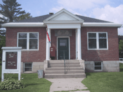
Calef Library in Washington
|
|

Washington, Vermont
|
|
| Country | United States |
| State | Vermont |
| County | Orange |
| Communities |
|
| Area | |
| • Total | 38.9 sq mi (100.7 km2) |
| • Land | 38.9 sq mi (100.6 km2) |
| • Water | 0.0 sq mi (0.0 km2) |
| Elevation | 1,765 ft (538 m) |
| Population
(2020)
|
|
| • Total | 1,032 |
| • Density | 27/sq mi (10.3/km2) |
| Time zone | UTC-5 (Eastern (EST)) |
| • Summer (DST) | UTC-4 (EDT) |
| ZIP Codes |
05675 (Washington)
05038 (Chelsea) 05086 (West Topsham) 05641 (Barre) 05654 (Graniteville) 05679 (Williamstown) |
| Area code(s) | 802 |
| FIPS code | 50-76750 |
| GNIS feature ID | 1462243 |
Washington is a small town in Orange County, Vermont, in the United States. In 2020, about 1,032 people lived there. People believe the town is named after George Washington, a famous American leader. However, it might also be named after Washington, Connecticut. This is because some people moved from that Connecticut town to Vermont around 1766.
Contents
History of Washington, Vermont
Early Land Disputes (1760s-1770s)
In the 1760s and 1770s, the land that is now Vermont was a bit confusing. Both New York and New Hampshire claimed it. This happened because they read their old land charters differently. People who moved to this area, then called New Connecticut, usually bought land from New Hampshire's governor, Benning Wentworth.
Later, the British government decided that New York was right. New York then tried to take control. They told people who bought land from New Hampshire that they had to pay a fee to keep their land. If they didn't pay, they could be forced to leave. Many Vermonters didn't like this. This led to the creation of a group called the Green Mountain Boys. They resisted New York's demands.
From Kingsland to Washington
To show it was in charge, New York created a town called Kingsland in 1770. It was far away in what was then Gloucester County. Kingsland didn't have any residents, but it was chosen as one of two county seats. A small jail and courthouse were built there. They were located at the start of a stream, which was later named the Jail Branch.
In 1780, Vermont became an independent republic. Its government renamed Kingsland to Washington. The town stayed empty until 1785. That year, Daniel Morse became the first person to own land there. His brother, John, soon followed him. More people kept arriving. By 1792, the town was fully organized. Records from 1794 show that 32 men could vote there.
Farming and Changes Over Time
The town center was on a hilltop near the Jail Branch. Washington was mostly made up of small sheep farms. These farms produced wool. Between 1820 and 1829, there were mills that processed wool. Raising sheep was most popular around 1830.
Washington's population reached its highest point in 1840, with 1,400 people. After that, the number of people slowly went down. This was because wool production decreased. Many farms and homes on the hilltop were left empty. The town center then moved downhill and further north. It settled along the Jail Branch and what is now Vermont Route 110.
When railroads arrived in the 1850s, dairy farming grew. This made it easier to sell milk to cities. By 1895, Washington had enough dairy farms for a creamery to open. Other towns nearby saw industries like granite manufacturing grow. But the railroads and new industries mostly bypassed Washington. It remained a quiet, rural town focused on farming.
By the late 1900s, small dairy farms struggled to compete. By the 1950s, many farms in Washington had closed. By 1960, the town's population had dropped to 565 people. Today, Washington is still a rural town. Most farms are no longer active. It has become a "bedroom community." This means many residents live there but travel to work in bigger cities like Barre, Montpelier, and Burlington.
Geography of Washington
Location and Size
The United States Census Bureau says that Washington covers about 38.9 square miles (100.7 square kilometers). Almost all of this area is land. Only a tiny part, 0.03%, is water.
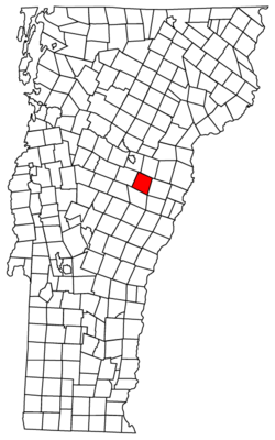
Washington is located south of U.S. Route 302. It shares borders with several other towns. To the northwest is Barre Town. Orange is to the north. Corinth is to the east. To the south is Chelsea. And to the west, you'll find Williamstown.
Population and People
| Historical population | |||
|---|---|---|---|
| Census | Pop. | %± | |
| 1790 | 72 | — | |
| 1800 | 500 | 594.4% | |
| 1810 | 1,040 | 108.0% | |
| 1820 | 1,160 | 11.5% | |
| 1830 | 1,374 | 18.4% | |
| 1840 | 1,359 | −1.1% | |
| 1850 | 1,348 | −0.8% | |
| 1860 | 1,249 | −7.3% | |
| 1870 | 1,113 | −10.9% | |
| 1880 | 922 | −17.2% | |
| 1890 | 820 | −11.1% | |
| 1900 | 820 | 0.0% | |
| 1910 | 762 | −7.1% | |
| 1920 | 660 | −13.4% | |
| 1930 | 697 | 5.6% | |
| 1940 | 730 | 4.7% | |
| 1950 | 650 | −11.0% | |
| 1960 | 565 | −13.1% | |
| 1970 | 667 | 18.1% | |
| 1980 | 855 | 28.2% | |
| 1990 | 937 | 9.6% | |
| 2000 | 1,047 | 11.7% | |
| 2010 | 1,039 | −0.8% | |
| 2020 | 1,032 | −0.7% | |
| U.S. Decennial Census | |||
Population in 2020
In 2020, the town of Washington had 1,032 people living there. There were 522 households, which are groups of people living together. Out of these, 371 were families. The town had 557 housing units, with 442 of them being lived in.
Most of the people in Washington were White (91.38%). A small number were African American (0.68%), Native American (0.48%), or Asian (0.58%). Some people identified with other races (0.78%) or with two or more races (4.84%). About 1.26% of the population was Hispanic or Latino.
Population in 2000
Back in 2000, there were 1,047 people in Washington. The town had 406 households and 291 families. The population density was about 26.9 people per square mile. Most people (97.23%) were White.
About 34.2% of households had children under 18 living with them. Most households (59.4%) were married couples. About 20.4% of all households were single individuals. The average household had 2.58 people.
The population was spread out by age. About 25.6% were under 18 years old. About 30.2% were between 25 and 44. The median age was 39 years old. This means half the people were older than 39 and half were younger.
The average income for a household in 2000 was $43,125. For families, it was $50,500. A small percentage of families (3.1%) and people (6.1%) lived below the poverty line.
Notable People from Washington
Washington has been home to several interesting people:
- Donald Milne: He was a member and clerk of the Vermont House of Representatives.
- Marion Milne: She also served as a member of the Vermont House of Representatives.
- Scott Milne: He ran for governor of Vermont in 2014. He also ran for U.S. Senator in 2016 and lieutenant governor in 2020.
- Daniel Peaslee: He was a Vermont lawmaker, a judge, and part of the governor's executive council.
- Carl C. Pope: Born in Washington, he became a lawmaker and judge in Wisconsin.
- Heman A. White: He was a member of both the Vermont House of Representatives and the Vermont Senate.
See also
 In Spanish: Washington (Vermont) para niños
 | Calvin Brent |
 | Walter T. Bailey |
 | Martha Cassell Thompson |
 | Alberta Jeannette Cassell |


