Wentworthville, New South Wales facts for kids
Quick facts for kids WentworthvilleSydney, New South Wales |
|||||||||||||||
|---|---|---|---|---|---|---|---|---|---|---|---|---|---|---|---|

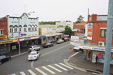
View from the railway footbridge
|
|||||||||||||||
| Population | 15,098 (2021 census) | ||||||||||||||
| • Density | 4,870/km2 (12,600/sq mi) | ||||||||||||||
| Established | 1810 | ||||||||||||||
| Postcode(s) | 2145 | ||||||||||||||
| Elevation | 30 m (98 ft) | ||||||||||||||
| Area | 3.1 km2 (1.2 sq mi) | ||||||||||||||
| Location | 27 km (17 mi) west of Sydney CBD | ||||||||||||||
| LGA(s) |
|
||||||||||||||
| State electorate(s) |
|
||||||||||||||
| Federal Division(s) | Parramatta | ||||||||||||||
|
|||||||||||||||
Wentworthville is a busy suburb in Sydney, New South Wales, Australia. It's located about 27 kilometres west of the main city centre, known as the Sydney CBD. Wentworthville is part of the larger Greater Western Sydney area. It's sometimes called 'Wenty' by locals. This suburb is special because it's split between two local government areas: the City of Parramatta and the Cumberland Council.
Contents
- History: First Peoples of the Land
- History: Early European Settlement
- Early Growth and Development
- Boundaries and Local Councils
- The Name: Wentworthville
- Street Names
- Historic Places
- Heritage-Listed Sites
- Shopping Areas
- Community and People
- Getting Around: Transport
- Schools in Wentworthville
- Sport
- Other Facilities
History: First Peoples of the Land
The original owners of the land where Wentworthville now stands are the Dharug or Durag peoples. Specifically, the Boolbainora clan lived here. They used to live near a thriving river system in Western Sydney.
Over time, these waterways became smaller creeks, and some even dry up. As Western Sydney grew, it became harder for the Dharug people to continue their traditional way of life.
History: Early European Settlement
Explorers first passed through Western Sydney in 1788. One trip in April 1788 likely went through what is now Wentworthville. Early towns like Parramatta and Toongabbie were set up in 1788.
The first person to officially receive land here was James Ruse in 1791. His land was around the Parramatta area. This opened the way for more land to be given out and developed.
Later, D’Arcy Wentworth received large pieces of land. He was a medical surgeon and landowner. He helped make sure the growing Sydney Colony had enough food. He encouraged both public and private farming in Western Sydney.
After D'Arcy Wentworth passed away, his large estate, called Darcyville, was divided up. This started around 1885. Before this, Wentworthville wasn't a separate suburb. It was just part of the "Parramatta" region, with no houses there.
Early Growth and Development
In the mid-1800s, many people wanted to buy land in the area. Land was divided into smaller pieces for houses and small farms. Wentworth's land was split into 600 lots.
A railway line was built through the area in 1864, heading towards Penrith. But Wentworthville didn't get its own train station until 1883. It was first called T. R. Smith's Platform, but two years later, it was renamed Wentworthville.
By 1886, maps showed two train stops: "Toongabbee" and "Parramatta." This allowed individual farmers and business owners to buy land. The Darcyville estate included the area around Wentworthville station.
One part of modern Wentworthville was bought by William Hart (Junior). He was from a timber and building company. In 1888, the historic house called "Castrella" was built by the Hart family. You can still see it today from Wentworth Avenue. Nearby is another historic house where the Tralee Gardens Preschool Centre is located.
The Wentworthville train station was likely there in 1902, even if it wasn't on every map. Maps from 1902 and 1918 show that the area around Wentworthville station was growing. More homes and businesses were being built.
The Fullagar estates were also large landholdings around Westmead. William Fullagar opened a famous cattle market. His family's estate, "Essington House," is now a Christian school. Sales of the Fullagar estates led to more people owning land in the area.
Boundaries and Local Councils
In 2007, the boundaries of Wentworthville changed. The northern part of the suburb became a new suburb called Constitution Hill.
Today, Wentworthville is its own suburb in Greater Western Sydney. As mentioned, it's divided between two local councils. The train line and Wentworth Avenue North form part of the border, with one side belonging to Parramatta Council.
The Name: Wentworthville
Wentworthville, along with Wentworth Falls in the Blue Mountains and Wentworth in far western New South Wales, are all named after the Wentworth family.
A large piece of land, about 8 square kilometres, was given to D'Arcy Wentworth in 1810. He was the father of William Wentworth, a famous Australian explorer, lawyer, newspaper owner, and politician.
Street Names
Many streets in Wentworthville are named after important people or places from its history:
- Fullagar Road is named after Mr. Fullagar, whose family owned large estates.
- Fyall Avenue is likely named after the Fyall family. Alexander Fyall came from Scotland and held important community roles.
- Darcy Road and Wentworth Avenue are named after D’Arcy Wentworth.
- Hart Drive (now part of the Cumberland Highway) is named after the Hart family. They built the historic "Castrella" house.
- Obriens Road might be named after a family who owned a fruit stall.
- Dorothy Road could be named after the “Dorothy mount estate” or perhaps William Charles Wentworth's granddaughter.
You can find more details about street names on the Parramatta Council website.
Historic Places
Heritage-Listed Sites
Wentworthville has a few places that are protected because of their historical importance:
- Caloola Road: Mount Dorothy Reservoir (This is a water storage facility located between Wentworthville and Constitution Hill.)
- ”Castrella”: This is the old home of William Hart Junior. It's located on the north side of the train line in Wentworth Avenue.
Shopping Areas
Wentworthville has two main shopping areas. The older, larger one is on the Cumberland Council side of the railway station. For many years, a Supa IGA supermarket was the main store there.
The newer shopping area is on the Great Western Highway. A Woolworths supermarket is the main store here. An Aldi supermarket is also nearby, on the other side of the Highway in South Wentworthville.
In the past, people used to go on "shopping tours" to Wentworthville. This was to visit the factory-outlets that sold products directly to the public. For example, the Bonds clothing factory in Dunmore Street used to sell clothes right from their factory.
Community and People
Wentworthville is a very diverse suburb!
- The most common backgrounds of people living here are Indian (31.5%), English (8.8%), Australian (8.0%), Chinese (6.2%), and Lebanese (3.2%).
- About 29.4% of people were born in Australia. Many others were born in India (35.7%), Sri Lanka (5.6%), China (3.2%), Nepal (2.4%), and the Philippines (2.0%).
- While 23.2% of people speak only English at home, many other languages are spoken too. These include Tamil (11.5%), Telugu (8.6%), Hindi (7.9%), Gujarati (7.1%), and Punjabi (4.8%).
- The most common religions are Hinduism (43.2%), Catholic (14.2%), and No Religion (10.8%).
Getting Around: Transport
Trains
Wentworthville railway station is on the North Shore & Western Line of the Sydney Trains network. Trains from here go west to places like Penrith and Richmond. After reaching the city, most trains continue north to places like North Sydney and Hornsby.
The station is also served by the Cumberland Line. This line connects Richmond to Leppington. A trip to the Sydney CBD usually takes about 35 minutes.
Buses
There are several bus routes that serve Wentworthville:
- The Liverpool–Parramatta T-way runs along the southern edge of the suburb.
- The North-West T-way is just outside the suburb on Mons Road.
- Transit Systems runs route 818 from Westmead Hospital to Merrylands via Wentworthville railway station.
- CDC NSW runs routes like 700 (Blacktown to Parramatta), 705 (Blacktown to Parramatta via the station), 711 (Blacktown to Parramatta), and 708 (Parramatta to Constitution Hill via the station).
Roads
Major roads run through or near Wentworthville:
- The M4 Western Motorway and the Great Western Highway both run east–west through the southern part of the suburb.
- The Cumberland Highway runs through the western side of Wentworthville. It connects Hornsby (via Pennant Hills Road) to Liverpool.
Schools in Wentworthville
- Wentworthville Public School
- Our Lady of Mt Carmel Primary School
- Darcy Road Public School
- Westmead Christian Grammar School (formerly Essington Christian Academy)
Sport
Wentworthville is home to the local rugby league team, the Wentworthville Magpies. They are a feeder club for the Parramatta Eels, a team in the NRL. The Magpies play in the Jim Beam Cup and the NSW Cup, even winning the NSW Cup in 2008!
Other Facilities
- Library: Wentworthville has a library that is part of the Cumberland Council library service.
- Swimming: The Wentworthville Swimming Pool is located near the railway station.
 | Bessie Coleman |
 | Spann Watson |
 | Jill E. Brown |
 | Sherman W. White |


