Westampton, New Jersey facts for kids
Quick facts for kids
Westampton, New Jersey
|
||
|---|---|---|
|
Township
|
||
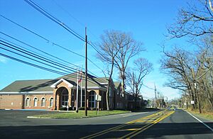
Westampton Township Municipal Building
|
||
|
||
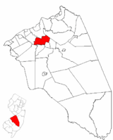
Westampton Township highlighted in Burlington County. Inset map: Burlington County highlighted in the State of New Jersey.
|
||
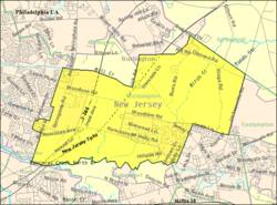
Census Bureau map of Westampton Township, New Jersey
|
||
| Country | ||
| State | ||
| County | ||
| Incorporated | March 6, 1850 | |
| Government | ||
| • Type | Township | |
| • Body | Township committee | |
| Area | ||
| • Total | 11.10 sq mi (28.75 km2) | |
| • Land | 10.97 sq mi (28.42 km2) | |
| • Water | 0.13 sq mi (0.33 km2) 1.15% | |
| Area rank | 200th of 565 in state 19th of 40 in county |
|
| Elevation | 72 ft (22 m) | |
| Population
(2020)
|
||
| • Total | 9,121 | |
| • Estimate
(2023)
|
9,195 | |
| • Rank | 261st of 565 in state 18th of 40 in county |
|
| • Density | 831.1/sq mi (320.9/km2) | |
| • Density rank | 404th of 565 in state 26th of 40 in county |
|
| Time zone | UTC−05:00 (Eastern (EST)) | |
| • Summer (DST) | UTC−04:00 (Eastern (EDT)) | |
| ZIP Code |
08060 – Mount Holly
|
|
| Area code(s) | 609 | |
| FIPS code | 3400578200 | |
| GNIS feature ID | 0882103 | |
| Website | ||
Westampton is a township located in Burlington County, in the state of New Jersey. It's part of a larger area that includes Philadelphia, Reading, and Camden. In 2020, about 9,121 people lived here.
Westampton became an official township on March 6, 1850. It was formed from parts of what was then called Northampton Township. Later, in 1880, a part of Westampton became Eastampton Township. The name "Westampton" comes from its original spot on the western side of Northampton Township.
Did you know that the National Weather Service has a special office in Westampton? This office helps forecast the weather for the Philadelphia area.
Contents
Exploring Westampton's Geography
Westampton Township covers a total area of about 11.10 square miles (28.75 square kilometers). Most of this area is land, with a small part being water.
Local Communities and Neighbors
Within Westampton, you can find smaller communities and places like Rancocas, Timbuctoo, and Woodlane.
Westampton shares its borders with several other towns in Burlington County. These include Burlington Township, Eastampton Township, Hainesport Township, Mount Holly, Mount Laurel, Springfield Township, and Willingboro Township.
Understanding Westampton's Population
| Historical population | |||
|---|---|---|---|
| Census | Pop. | %± | |
| 1850 | 1,507 | — | |
| 1860 | 1,313 | −12.9% | |
| 1870 | 1,369 | 4.3% | |
| 1880 | 715 | * | −47.8% |
| 1890 | 688 | −3.8% | |
| 1900 | 567 | −17.6% | |
| 1910 | 564 | −0.5% | |
| 1920 | 478 | −15.2% | |
| 1930 | 491 | 2.7% | |
| 1940 | 573 | 16.7% | |
| 1950 | 716 | 25.0% | |
| 1960 | 1,114 | 55.6% | |
| 1970 | 2,680 | 140.6% | |
| 1980 | 3,383 | 26.2% | |
| 1990 | 6,004 | 77.5% | |
| 2000 | 7,217 | 20.2% | |
| 2010 | 8,813 | 22.1% | |
| 2020 | 9,121 | 3.5% | |
| 2023 (est.) | 9,195 | 4.3% | |
| Population sources: 1850–2000 1850–1920 1850–1870 1850 1870 1880–1890 1890–1910 1910–1930 1940–2000 2000 2010 2020 * = Lost territory in previous decade. |
|||
Population Changes Over Time
The population of Westampton has grown quite a bit over the years. In 2010, there were 8,813 people living in the township. This was a big jump from the 7,217 people counted in 2000. By 2020, the population had increased again to 9,121.
In 2010, there were 3,195 households in Westampton. About 34.7% of these households had children under 18 years old. The average household had 2.76 people.
The population's age groups in 2010 were:
- 24.4% were under 18 years old.
- 7.7% were between 18 and 24.
- 27.2% were between 25 and 44.
- 30.3% were between 45 and 64.
- 10.4% were 65 years or older.
The average age in Westampton was about 39.3 years.
Learning in Westampton: Schools and Education
Students in Westampton attend public schools from pre-kindergarten up to eighth grade through the Westampton Township Schools.
Westampton Township Schools
The Westampton Township School District has two schools:
- Holly Hills Elementary School: This school teaches students from pre-kindergarten through 3rd grade.
- Westampton Intermediate School / Westampton Middle School: This school serves students in pre-kindergarten and grades 4 through 8.
In the 2021-2022 school year, the district had 937 students. This means there were about 10.7 students for every teacher.
High School Education
For high school, students from Westampton go to Rancocas Valley Regional High School. This school also welcomes students from Eastampton Township, Hainesport Township, Lumberton Township, and Mount Holly Township.
In the 2021-2022 school year, Rancocas Valley Regional High School had 2,048 students. There were about 14.6 students for every teacher. The school is located in Mount Holly Township.
Vocational Training Opportunities
The Burlington County Institute of Technology offers special training programs for students across Burlington County. It has two campuses, and one of them is right here in Westampton! The other campus is in Medford.
Getting Around Westampton: Transportation
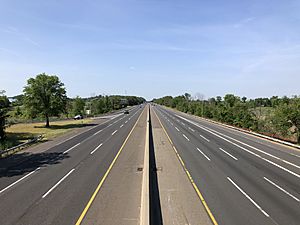
Westampton has many roads, totaling about 55.24 miles (88.90 kilometers). The township itself takes care of most of these roads.
Major Highways and Roads
Two important highways pass through Westampton:
- New Jersey Turnpike: About 4.1 miles (6.6 kilometers) of this major highway are in Westampton. It includes the toll gate for Exit 5.
- Interstate 295: This highway runs through the northwestern part of the township for about 2.5 miles (4.0 kilometers) and has one exit, Exit 45.
A key county road, County Route 541, also goes through Westampton from one end to the other.
Public Bus Services
If you need to get around using public transportation, NJ Transit offers bus service on route 413. This route connects Burlington and Camden.
There's also a local bus service called BurLink.
- The B1 route goes between Beverly and Pemberton.
- The B2 route connects Beverly and Westampton Township.
For trips to New York City, Academy Bus provides service from a park-and-ride spot near Exit 5 of the New Jersey Turnpike. You can catch a bus to places like the Port Authority Bus Terminal in Midtown Manhattan, Jersey City, and the Wall Street area in Lower Manhattan.
People from Westampton: Notable Residents
Many interesting people have lived in or are connected to Westampton Township. Here are a few:
- Carmine DeSopo (born 1940): A politician who served in the New Jersey General Assembly from 1996 to 1998.
- Henry Rowan (1923–2015): An engineer and generous person. Rowan University is named after him!
- José F. Sosa (born 1950): A politician who served in the New Jersey General Assembly from 1992 to 1994.
- Jean Stanfield: A politician elected to the New Jersey General Assembly in 2019.
- Kelsi Worrell (born 1994): A talented swimmer who won a gold medal in the 100-meter butterfly at the 2015 Pan American Games.
See also
 In Spanish: Municipio de Westampton para niños


