Wheeler County, Texas facts for kids
Quick facts for kids
Wheeler County
|
|
|---|---|

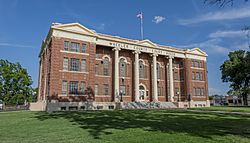
Wheeler County Courthouse
|
|

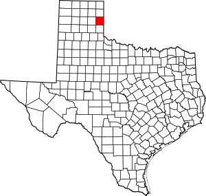
Location within the U.S. state of Texas
|
|
 Texas's location within the U.S. |
|
| Country | |
| State | |
| Founded | 1879 |
| Named for | Royall T. Wheeler |
| Seat | Wheeler |
| Largest city | Shamrock |
| Area | |
| • Total | 915 sq mi (2,370 km2) |
| • Land | 915 sq mi (2,370 km2) |
| • Water | 1.0 sq mi (3 km2) 0.1%% |
| Population
(2020)
|
|
| • Total | 4,990 |
| • Density | 5.454/sq mi (2.106/km2) |
| Time zone | UTC−6 (Central) |
| • Summer (DST) | UTC−5 (CDT) |
| Congressional district | 13th |

Wheeler County is a county located in the U.S. state of Texas. It is in the eastern part of the Texas Panhandle. As of the 2020 census, about 4,990 people lived there.
The main town and county seat is Wheeler. This is where the county government offices are located. The county was created in 1876 and officially organized in 1879. It was named after Royall T. Wheeler, who was a chief justice of the Texas Supreme Court.
Wheeler County used to be a "dry county." This meant it was against the law to sell alcohol anywhere in the county. However, around 2010, the town of Shamrock voted to allow alcohol sales. Now, Shamrock is the only place in Wheeler County where you can buy alcoholic drinks.
The Pioneer West Museum is the historical museum for Wheeler County. It is located in Shamrock, near U.S. Highway 83.
Contents
Exploring Wheeler County Geography
According to the U.S. Census Bureau, Wheeler County covers about 915 square miles. Almost all of this area is land. Only a tiny part, about 1.0 square mile, is covered by water.
Main Roads and Highways
Several important roads pass through Wheeler County:
 Interstate 40: A major highway that crosses the United States.
 U.S. Highway 83: Another important north-south route.
 State Highway 152: A state road within Texas.
The famous U.S. Highway 66 used to run through the county. While it's no longer an official highway, you can still see special brown historic signs along its old path.
Neighboring Counties
Wheeler County shares its borders with several other counties:
- Hemphill County (to the north)
- Roger Mills County, Oklahoma (to the northeast)
- Beckham County, Oklahoma (to the east)
- Collingsworth County (to the south)
- Gray County (to the west)
- Donley County (to the southwest)
- Roberts County (to the northwest)
Wheeler County Population Changes
The population of Wheeler County has changed over the years. Here's a look at how many people have lived there during different census years:
| Historical population | |||
|---|---|---|---|
| Census | Pop. | %± | |
| 1880 | 512 | — | |
| 1890 | 778 | 52.0% | |
| 1900 | 636 | −18.3% | |
| 1910 | 5,258 | 726.7% | |
| 1920 | 7,397 | 40.7% | |
| 1930 | 15,555 | 110.3% | |
| 1940 | 12,411 | −20.2% | |
| 1950 | 10,317 | −16.9% | |
| 1960 | 7,947 | −23.0% | |
| 1970 | 6,434 | −19.0% | |
| 1980 | 7,137 | 10.9% | |
| 1990 | 5,879 | −17.6% | |
| 2000 | 5,284 | −10.1% | |
| 2010 | 5,410 | 2.4% | |
| 2020 | 4,990 | −7.8% | |
| U.S. Decennial Census 1850–2010 2010 2020 |
|||
In 2000, there were 5,284 people living in the county. The average number of people per square mile was about 6. Most households were families, with many married couples living together. About 29% of households had children under 18. The median age in the county was 42 years old.
Towns and Communities in Wheeler County
Wheeler County has several towns and smaller communities.
Cities
Census-Designated Places
Other Small Communities
See also
 In Spanish: Condado de Wheeler (Texas) para niños
 | James B. Knighten |
 | Azellia White |
 | Willa Brown |


