
Wilcannia facts for kids
Quick facts for kids WilcanniaNew South Wales |
|||||||||
|---|---|---|---|---|---|---|---|---|---|

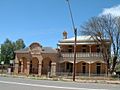
Central Darling Council Chambers
|
|||||||||

Wilcannia
Location in New South Wales
|
|||||||||
| Population | 735 (2021 census) | ||||||||
| Established | 1866 | ||||||||
| Postcode(s) | 2836 | ||||||||
| Elevation | 75.0 m (246 ft) | ||||||||
| Location |
|
||||||||
| LGA(s) | Central Darling Shire | ||||||||
| County | Young County | ||||||||
| State electorate(s) | Barwon | ||||||||
| Federal Division(s) | Parkes | ||||||||
|
|||||||||
Wilcannia is a small town in north-western New South Wales, Australia. It is part of the Central Darling Shire. The town sits on the Darling River. In the mid-1800s, Wilcannia was the third largest river port in Australia. This was during the time when river boats were very important for transport. In 2021, Wilcannia had a population of 735 people.
Contents
History of Wilcannia
The land around Wilcannia traditionally belongs to the Barkindji people. They call the river "Baaka." The name Wilcannia might come from an Aboriginal word. It could mean "gap in the bank where floodwaters escape" or "wild dog."
Early European Exploration and Growth
In 1835, explorer Major Thomas Mitchell was the first European to visit this area. He followed the Darling River to where Menindee is today.
The town of Wilcannia was officially created in June 1866. By 1871, 264 people lived there. This number grew to 1,424 by 1881. Wilcannia was at its busiest in the 1880s. It had about 3,000 people, 13 hotels, and its own newspaper called the Western Grazier.
Wilcannia was one of the main river ports on the Murray-Darling river system. Other important ports included Wentworth, Echuca, Mannum, and Goolwa. These ports were vital for moving goods like wool and wheat using paddle-steamers.
Geography of Wilcannia
Wilcannia is located where the Barrier Highway crosses the Darling River. It is about 965 kilometres (600 miles) from Sydney. The area has a dry to desert-like environment. It gets about 255 millimetres (10 inches) of rain each year.
Local Environment and Land Use
Wilcannia is in the Darling Riverine Plains area. This means the landscape is used to floods. Common plants include River Red Gum, Yellow Box, Oldman Saltbush, and Lignum.
The land around Wilcannia is very spread out. It is mainly used by farmers who raise sheep. These farms are very large.
Climate in Wilcannia
Wilcannia has a semi-arid climate. This means it has hot summers and mild to cool winters. The average high temperature in summer is 34 °C (93 °F). In winter, the average high is 19 °C (66 °F). The hottest temperature ever recorded in Wilcannia was 50.0 °C (122.0 °F) on January 11, 1939.
| Climate data for Wilcannia (Reid Street) | |||||||||||||
|---|---|---|---|---|---|---|---|---|---|---|---|---|---|
| Month | Jan | Feb | Mar | Apr | May | Jun | Jul | Aug | Sep | Oct | Nov | Dec | Year |
| Record high °C (°F) | 48.2 (118.8) |
47.1 (116.8) |
44.4 (111.9) |
38.4 (101.1) |
31.3 (88.3) |
29.3 (84.7) |
30.6 (87.1) |
32.4 (90.3) |
39.4 (102.9) |
40.7 (105.3) |
45.2 (113.4) |
46.8 (116.2) |
48.2 (118.8) |
| Mean daily maximum °C (°F) | 35.4 (95.7) |
34.6 (94.3) |
31.3 (88.3) |
26.2 (79.2) |
21.2 (70.2) |
17.7 (63.9) |
17.1 (62.8) |
19.5 (67.1) |
23.5 (74.3) |
27.4 (81.3) |
31.2 (88.2) |
33.9 (93.0) |
26.6 (79.9) |
| Mean daily minimum °C (°F) | 19.8 (67.6) |
19.3 (66.7) |
16.2 (61.2) |
11.7 (53.1) |
7.9 (46.2) |
5.4 (41.7) |
4.2 (39.6) |
5.6 (42.1) |
8.4 (47.1) |
12.2 (54.0) |
15.6 (60.1) |
18.2 (64.8) |
12.0 (53.6) |
| Record low °C (°F) | 9.2 (48.6) |
8.8 (47.8) |
6.4 (43.5) |
1.8 (35.2) |
−2.5 (27.5) |
−2.8 (27.0) |
−5.0 (23.0) |
−3.3 (26.1) |
−0.5 (31.1) |
3.4 (38.1) |
3.9 (39.0) |
8.4 (47.1) |
−5.0 (23.0) |
| Average rainfall mm (inches) | 25.9 (1.02) |
26.5 (1.04) |
24.7 (0.97) |
17.1 (0.67) |
23.6 (0.93) |
22.2 (0.87) |
18.4 (0.72) |
17.5 (0.69) |
15.9 (0.63) |
25.2 (0.99) |
20.9 (0.82) |
26.0 (1.02) |
263.9 (10.39) |
| Average precipitation days | 2.9 | 2.9 | 2.7 | 2.7 | 4.1 | 4.6 | 4.4 | 4.2 | 3.4 | 4.0 | 3.4 | 3.2 | 42.5 |
| Source: Bureau of Meteorology | |||||||||||||
Extreme Weather Events
On November 9, 1950, a strong thunderstorm hit Wilcannia. It brought powerful winds and large hail, as big as cricket balls. Two people were hurt, and many homes lost their roofs. Almost every house in town was damaged by the hail.
Facilities in Wilcannia
Wilcannia has a Central School that includes a pre-school. It teaches students up to Year 12. For the last two years, students learn through distance education. In 2020, Sarah Donnelley, a teacher at Wilcannia Central School, won the ARIA Award for Music Teacher of the Year.
Baaka Cultural Centre
Construction started in August 2023 on the Baaka Cultural Centre. It is on the main road through Wilcannia. The building is shaped like an emu's foot. It will be a place for tourists to visit and a gallery for local art and historical items. Local people are working on building it. Specialists in stonemasonry and rammed earth construction are also helping. Baaka is the Paakantyi word for the Darling River.
Local Radio Stations
The local community radio station is Wilcannia River Radio on 103.1 MHz. It shares important information and talks about topics like COVID-19 and climate change. Other radio stations available include Outback Radio 2WEB on 99.9 MHz, ABC Radio National, and ABC Western Plains.
Transport in Wilcannia
Public Transport Options
.jpg)
NSW TrainLink coaches serve Wilcannia. These coaches travel between Dubbo railway station and Broken Hill. They stop in town and at the Emmdale Roadhouse. Bus route 595 also connects Wilcannia to Broken Hill.
Wilcannia Airport
Wilcannia Airport has the code WIO (IATA) and YWCA (ICAO). It is 9 kilometres (6 miles) from the town centre. The airport has two runways: one made of asphalt that is 3,051 feet long, and one made of clay that is 3,701 feet long. Its coordinates are 31°31′10″S 143°22′50″E.
Community and Population

According to the 2016 Census, Wilcannia had 549 residents. Most of these, 407 people (74.4%), were of Aboriginal or Torres Strait Islander background. Most are from the Barkindji nation. There are 223 homes in Wilcannia. A 2015 report listed Wilcannia as one of the most socially disadvantaged areas in New South Wales.
Community Challenges
Wilcannia has faced challenges, including concerns about water quality. Residents have reported that the local water is not safe to drink. Because of this, many people rely on bottled water brought from Broken Hill, which is almost 200 kilometres (124 miles) away.
During the COVID-19 pandemic in New South Wales, Wilcannia was one of the towns most affected. The town had a very high number of cases compared to its population. About 90% of those who tested positive were Aboriginal people. Community leaders had warned authorities a year before that crowded living conditions could lead to a crisis if the virus reached the town.
Wilcannia in the Media
In 2017, a BBC3 documentary called Reggie Yates: Hidden Australia showed some of the social issues in Wilcannia. Later, the BBC apologized for the program, saying it gave a biased view.
In July 2017, ABC Radio National created a 6-part series called Positively Wilcannia. This series highlighted the good things happening in the community.
During the wider COVID-19 pandemic in Australia, many news outlets reported on how poor living conditions and crowded homes in Wilcannia led to the town having Australia's highest rate of COVID-19 cases per person.
| Historical population | ||
|---|---|---|
| Year | Pop. | ±% |
| 1921 | 592 | — |
| 1933 | 623 | +5.2% |
| 1947 | 799 | +28.3% |
| 1954 | 821 | +2.8% |
| 1961 | — | |
| 1966 | 800 | — |
| 1971 | 936 | +17.0% |
| 1976 | 1,023 | +9.3% |
| 1981 | 982 | −4.0% |
| 1986 | 1,048 | +6.7% |
| 1991 | 942 | −10.1% |
| 1996 | 688 | −27.0% |
| 2001 | 685 | −0.4% |
| 2006 | 596 | −13.0% |
| 2011 | 604 | +1.3% |
| 2016 | 549 | −9.1% |
| 2021 | 539 | −1.8% |
| Source: Australian Bureau of Statistics data. | ||
Notable People from Wilcannia
- Annie Moysey, known as Wilcannia's Grandmother.
- The Wilcannia Mob, a hip hop music group of five Indigenous Australians.
- Owen Whyman, who started the political party Indigenous-Aboriginal Party of Australia.
Images for kids
-
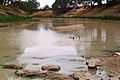
from the bed of the Darling River
-
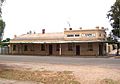
Street Scene
-
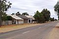
Street Scene
-
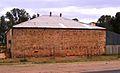
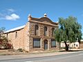
Former warehouse now Residence and Art Studio
-
Wilcannia Police Station with Melia azedarach
-
Now a Pharmacy and residence 2016
-
Residence near the Anglican Church
-
Old Post Office
-
Old warehouse
-
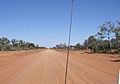
The Bourke-Wilcannia road, near Bourke
-
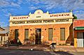
Wilcannia Athenaeum


.jpg)
See also
 In Spanish: Wilcannia para niños
